Near Sacramento River Bike Trail north of J Street.
John Sutter, a central figure in California's gold rush and Sacramento's early development, would hardly recognize his embarcadero today. Located just north of the present I Street bridge, Sutter's landing in 1848 was little more than a . . . — — Map (db m113064) HM
On I Street west of 2nd Street, on the left when traveling west. Reported permanently removed.
As you gaze down, you look back in time at Sacramento's original level. The building that once stood here was probably raised in the 1860s, creating this courtyard and providing access to hollow sidewalk segments. Imagine how easily flood waters . . . — — Map (db m201277) HM
Near K Street at Interstate 5, on the right when traveling east.
By the time the 19th century drew to a close, great wealth had been accumulated by a few, but enormous social problems had emerged throughout the country: the labor movement fought for union controls; child labor became a significant concern; . . . — — Map (db m229830) HM
Near K Street at Interstate 5, on the right when traveling east.
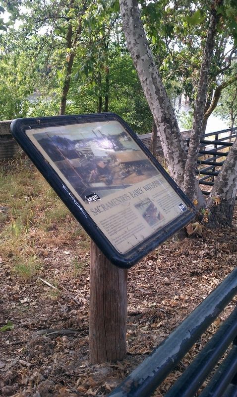
The 1890s was a pivotal decade of invention. The transmission of electricity from the Folsom Power House to Sacramento in 1895 was, by its size and purpose, a major national achievement. The hydroelectric power generated was three-phase alternating . . . — — Map (db m229904) HM
Near K Street at Interstate 5, on the right when traveling east.
By the late 1830s, so many different nations had explored and settled in California that the Mexican government feared it would lose region. The British and French had arrived both by land, from Canada, and by sea; the Russians had settled along the . . . — — Map (db m229802) HM
Near K Street at Interstate 5, on the right when traveling east.
The first attempts to establish a government for the City of Sacramento in 1849 resulted in many meetings being called, but few were attended. Some of the earliest meetings were attended by those who represented saloon and gambling interests. The . . . — — Map (db m229806) HM
“The Docks” area is significant in that California’s first railroad began here. Railroads have directly influenced the development of the southern waterfront for more than 100 years. The Sacramento Valley Rail Road, the pioneer steam . . . — — Map (db m16727) HM
“The Docks” has had a remarkably varied occupational history. Gold Rush immigrants camped along the riverbank. In the following years, a limited number of individuals and families lived in the area in private residences and lodging . . . — — Map (db m16511) HM
Near K Street at Interstate 5, on the right when traveling east.
Even after the great national stock panic of 1893 disabled the labor force in America, many events such as the Spanish American War and World War I – temporarily glossed over the plight and discontent of the American working class. Then, the Great . . . — — Map (db m229969) HM
Near K Street at Interstate 5, on the right when traveling east.
The equality of education in Sacramento area schools had been the focus of a number of reformers. Educator activists in the 19th century are well represented by Sarah Jones, and in the 20th century by Mary Tsukamoto. Jones was an African American . . . — — Map (db m229891) HM
The Bridge Lunch Restaurant was the last of a long line of restaurants, saloons and boardinghouses located at, or nearby, 1323 Front Street, the first brick structure in the city. George Zins, a native of Searsburg, Lorraine, started a . . . — — Map (db m16728) HM
Near K Street at Interstate 5, on the right when traveling east.
Sutter employed a group of Mormons, under the supervision of James Marshall, to build a lumber mill on the American River at Coloma. The men worked on building a tailrace which would guide water from the mill back to the river. By day the men . . . — — Map (db m229803) HM
Near K Street at Interstate 5, on the right when traveling east.
The birth of Sacramento City was in the hands of John Sutter, Jr. who, in late 1848, hired a surveyor to map out a city on his father’s land. After the city limits were established, he began to sell city lots. Sutter’s principal land agent was Peter . . . — — Map (db m229807) HM
Another distinctive era in the demographic history of the southern waterfront occurred when the construction of several interurban railroad lines along Front Street revitalized the area. In the first decade of the 20th century, several interurban . . . — — Map (db m16544) HM
Near K Street at Interstate 5, on the right when traveling east.
William Land was Sacramento’s own “Horatio Alger” – a local boy who became financially successful. As a very young boy, Land worked as a baggage handler at the Central Pacific Railroad Passenger Station. He was so efficient at picking up visitors at . . . — — Map (db m229893) HM
In 1911, the Northern Electric Railway Company, along with Sacramento and Yolo counties, built the Northern Electric Bridge. The bridge carried a single railroad track with twin motor-vehicle roadways. Pedestrian walks cantilevered from the central . . . — — Map (db m16492) HM
On 2nd Street at J Street, on the left when traveling south on 2nd Street.
This statue commemorates the glory of The Pony Express, which started here at 2:45 a.m. on April 4, 1860, when Sam Hamilton galloped into a blinding rainstorm on the first lap of the 1,966-mile trip to St. Joseph, Missouri. During its 18-month . . . — — Map (db m11326) HM
Near K Street at Interstate 5, on the right when traveling east.
By the 1950s, urban decay had left an almost indelible mark on Sacramento’s “West End.” Redevelopment interests planned to demolish the oldest section of the central City west of Seventh Street. The State Division of Highways also proposed a freeway . . . — — Map (db m230178) HM
In the early 1920’s the California Transportation Company, the leading passenger carrier on the Sacramento and San Joaquin rivers, announced plans to build two modern passenger vessels for its Sacramento to San Francisco run. In 1927, the Delta . . . — — Map (db m16507) HM
Near K Street at Interstate 5, on the right when traveling east.
Curing the sick and injured was the primary mission of the Catholic Sisters of Mercy Order when they arrived in Sacramento in 1857. Not long after their arrival, the Sisters established the first Catholic School in Sacramento. In 1896, the Sisters . . . — — Map (db m229822) HM
Near K Street at Interstate 5, on the right when traveling east.
Hardin Bigelow was a deeply-involved founder and pioneer of the new City. A contractor, he helped build Sacramento and its early levees. In October 1850, while serving as mayor, he ordered squatters on city lots to vacate the properties. The . . . — — Map (db m229808) HM
Throughout history, two categories of ships, merchants and naval combatants, have carried out the world’s seagoing activities. Those of the merchant marine, known as merchantmen, carry cargo, passengers, and perform special functions during times of . . . — — Map (db m16468) HM
On 2nd Street at L Street, on the right when traveling north on 2nd Street.
This monument was erected by the men and women of the Southern Pacific Company, who, in 1930, were carrying on the work he began in 1860. He convinced four Sacramento merchants that his plan was practical and enlisted their help. Ground was broken . . . — — Map (db m11735) HM
Identifying A Need
By the early 1930’s, Americans were moving away from trains and ships and turning to automobiles as their mode of transporation. As a result, traffic on roadways increased dramatically. In Sacramento, M Street (now . . . — — Map (db m16490) HM
Near K Street at Interstate 5, on the right when traveling east.
The transcontinental railroad across the U.S. was a monumental effort in an era when the world was accustomed to monumental projects in the name of global transportation. Even before the transcontinental railroad was completed, the “Big Four” . . . — — Map (db m229819) HM
Constructed during the early years of the Vietnam War, she was commissioned as a “Combat Supply and Auxiliary Support Ship” (AEO-1). At 793’ and 53,000 tons, she is by far the largest ship in the U.S. Fleet to be named . . . — — Map (db m72896) WM
A wooden sloop, 229 feet long and with a crew of 138, she was commissioned for blockade service during the Civil War. First, she contained Confederate ships off the coast of North Carolina and later Atlantic ports in Europe. In 1865, she . . . — — Map (db m16470) HM
Brought into service in 1914 to join the United States “Great White Fleet”, dubbed such for the sparkling white paint used on naval ships at the time, she was in service 28 years and two world wars. A 226-foot gleaming white steam . . . — — Map (db m16475) HM
As part of our nation’s maritime history, USS Sacramento steamed more than one-half million miles during her proud service in the United States Navy.
She logged 64,000 miles convoying 483 ships through submarine-infested European waters during . . . — — Map (db m16483) HM
On Firehouse Alley at J Street, on the left when traveling west on Firehouse Alley.
Sacramento’s first post office was located on this lot in 1849. In 1853, Henry E. Robinson bought the lot from Samuel Brannan and built this three story brick building, naming it the Jones Hotel. The Sacramento Pioneer Association first organized . . . — — Map (db m149178) HM
Sacramento’s importance during the Gold Rush was as a supply depot for outlying towns in the foothill-mining region. The City’s central location to the northern mining region, combined with reliable year-round river transportation to San Francisco, . . . — — Map (db m16496) HM
Near K Street at Interstate 5, on the right when traveling east.
During World War I, Sacramento secured its first Army Air Corps base, Mather Field. After the war ended in 1918, the base was closed until 1931, when an Army crew reopened Mather Field to undertake the largest military aircraft war game in the . . . — — Map (db m229916) HM
Near K Street at Interstate 5, on the right when traveling east.
The reform movement of the late 19th century brought women into a new sphere of activity. The desire to improve the good of humanity led women to found cultural organizations and women’s clubs. Women became politically active with child labor, . . . — — Map (db m229889) HM
Near K Street at Interstate 5, on the right when traveling east.
Perhaps nowhere was the impact of women in the workforce more keenly experienced than in the Sacramento area canneries during World War I and World War II. Canning facilities operated at the highest level of production possible. Women dominated the . . . — — Map (db m229972) HM
On 23rd Street south of Q Street, on the left when traveling north.
On June 24, 1895 the Sisters of Mercy responded to the healthcare needs of the people of Sacramento by acquiring the Ridge Home, a small private hospital, from two local physicians. In 1896, the Sisters broke ground for the construction of a larger . . . — — Map (db m91585) HM
Established 1909, Dedicated 1913
Designated Point of Historical Interest
February 18, 19883
Calif. Dept. of Parks & Recreation
(Reg. Sac - 006)
Oldest Portugese National Church
West of New England
Plaque by Portuguese Historical & . . . — — Map (db m91856) HM
On R Street at 3rd Street, on the left when traveling west on R Street.
The Sacramento Valley Railroad running from Sacramento to Folsom, was begun at this site on February 12, 1855. Here, at Third and R Streets, was located the Sacramento passenger terminal. The turntable and freight depot were at Third and Front . . . — — Map (db m16056) HM
First panel:
The Comité Centro Mexicano commemorates the same respect and sense of equality dictated by this historical plaque. With great honor we re-dedicate it in honor of all humanity on this date.
From 1948 to 1975, El Centro . . . — — Map (db m91735) HM
138 entries matched your criteria. Entries 101 through 138 are listed above. ⊲ Previous 100