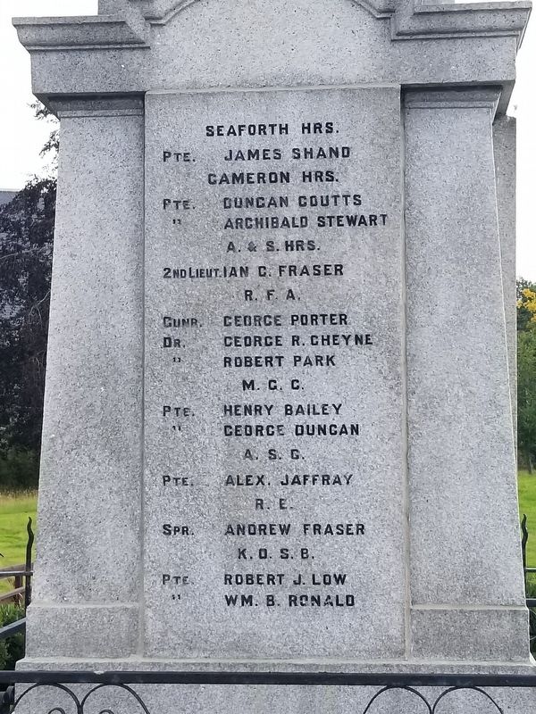
On Main Road at Scotland Route B9170, on the left when traveling south on Main Road.
Erected
In Grateful
Remembrance Of
The Men Connected With This District
Who Fell in the Great War 1914 – 1919.
Gordon Hrs.
Captn. George A.G. Moir · Sergt. George Gray · Sergt. Alex. G. Leask · Cpl. Herbert W. Burr · Cpl. Alex. G. Mutch . . . — — Map (db m128026) WM
On an unnamed road 1.4 kilometers west of Scotland Route B9001, on the left when traveling west.
( inscribed around the top of the tower )
To the Memory of Provost Robert Davidson & The Burgesses of Aberdeen Who Fell Here AD.1411
Harlaw
July 24
A.D.1411
Erected by the
Burgh of Aberdeen
A.D.1911
Adam Maitland
Lord . . . — — Map (db m128264) HM WM
Near Scotland Route B993 3.1 kilometers south of an unnamed road, on the left when traveling south.
About Castle Fraser
In the early 1600s, Andrew Fraser of Muchall transformed the home of his ancestors into a magnificent symbol of wealth, status and European culture. Castle Fraser's great entrance court, soaring towers and heraldic carvings . . . — — Map (db m128340) HM
On Market Place (Scotland Route B9001) at W High Street, on the right when traveling north on Market Place.
In
Proud and
Grateful Memory
Of the Men of
Inverurie and District
Who Gave Their Lives
In the Great War
1914 — 1918
“At the going down of the
sun and in the morning
we will remember them.” . . . — — Map (db m128262) HM
On Grove Road (Scotland Route B993) at Station Road, on the left when traveling north on Grove Road.
In Memory Of
James Mitchell · Carrier
1773 1857
All Ye Who Thirst · Come Drink
From This Flow of Pure Water
Which Springs at Dalfling in
The Shadow of Benachie — — Map (db m128269) HM
On Grove Road (Scotland Route B993) at Station Road, on the left when traveling north on Grove Road.
In Proud and Grateful Memory of
The sons and Daughters of
Kemnay Who Laid Down Their Lives
For Freedom in the Great War.
Pte. David S. Abel · Pte. John Anderson · Pte. Douglas Auld · Pte. James D. Bannerman · Pte. John P.B. Berry · Pte. . . . — — Map (db m128268) WM
On W High Street at Victoria Street, on the left when traveling west on W High Street.
This striking building at the West End of High Street, first opened its doors, in 1934, as the Victoria cinema, closing more than sixty years later, in 1998. These premises are now named after the Gordon Highlander, the only surviving example of . . . — — Map (db m128235) HM
Near Scotland Route B993 3.1 kilometers south of an unnamed road, on the left when traveling south.
Welcome to Castle Fraser Walled Garden
Castle Fraser's gardens were originally much closer to the castle, as was typical in 17th century Scotland. In 1794, the lady laird, Miss Elyza Fraser commissioned Thomas White to draw up a plan to . . . — — Map (db m128341) HM
On South Road at Rocksley Drive, on the right when traveling north on South Road.
A Tribute From
The People of Boddam
To the Men and Women
Who Served at
Royal Air Force Buchan
1952 — 2003
Boddam Community Association 2009 — — Map (db m128019) WM
Near A981 2.7 kilometers south of A950, on the right when traveling south.
Fedderate Castle
From A.D. 1370 to 1573 the home of the Craufurds of Fedderate, ancestors of the Swedish Family of Crafoord
A castle seems to have been on this site since AD 1200. The ruins are from a castle built ab. 1475. It was described as a . . . — — Map (db m122811) HM
On South Road at King Street, on the right when traveling north on South Road.
Unveiled 6th August
1922
And Handed Over to the Custody of
The Provost Magistrates & Councillors
Of the Burgh of Peterhead
To the Glory of God
And In Honour Of
The Men OF This Town Who Gave Their Lives
For Freedom in the Great War . . . — — Map (db m128020) WM
On South Road at King Street, on the right when traveling south on South Road.
Their Name Liveth For Evermore.
On these panels are commemorated those members of His Majesty’s Forces who gave their lives for their country in the Great War Whose graves are in this churchyard but are not marked by separate headstones
A Sailor . . . — — Map (db m128024) WM
On Church Crescent (Scotland Route A981) at Gladstone Terrace, on the right when traveling east on Church Crescent.
To The
Glory Of God
And In Proud
And Grateful
Memory
Of The Men
From The Parish Of
New Deer
Who Made The
Supreme Sacrifice
In The Wars
1914 – 1919
and
1939 – 1945
Sergeant A. Davidson Gordons · Sergeant R. . . . — — Map (db m128025) WM
On Grant Street at Park Street, on the left when traveling west on Grant Street.
Erected by Public Subscription
To the Memory of
Benjamin Maclean, M.A., Divinity Student
Who Lost His Life on 26th August 1909, in
A Successful Effort to Rescue a Bather from
Drowning, off the East Beach, Burghead
“Greater Love . . . — — Map (db m128158) HM
On Grant Street at Park Street, on the left when traveling west on Grant Street.
Erected by the Inhabitants
Of Burghhead to the Memory
Of Their Fellow Townsmen
Whose Lives Were Sacrificed
In the Great War
1914 — 1919
That Both a Man Live For
To Serve His Fellows
To Honour His Country to Glorify God
And . . . — — Map (db m128157) WM
On Forteath Street at Bath Street, on the left when traveling west on Forteath Street.
The Harvest Reaper was a 45 foot long, Fyfie design fishing boat built of larch on oak at Wilson (Cockie) Noble's yard in Fraserburgh in 1931. She was powered by a Kelvin Recardo diesel engjine. She fished from Frasertburgh (the other Broch!) . . . — — Map (db m128159) HM
Near Scotland Route B9089 at Route B9011, on the left when traveling east.
Five Centuries in Kinloss
The Abbey Buildings
By the end of the 13th Century the majority of buildings in the Abbey Precinct would have been complete. The church lay on an east-west alignment with the main cloister to the south. To the east of . . . — — Map (db m128053) HM
On Scotland Route A96 0.5 kilometers north of an unnamed road, on the left when traveling east.
The Pictish Rodney’s Stone was carved around 1,200 years ago.
A beacon for the community, it may have marked a place where people came to be baptised, married or hear Mass.
Brodie born and bred … The family home to over #400 varieties of . . . — — Map (db m128035) HM
Near Scotland Route B9089 at Route B9011, on the left when traveling west.
From Citeaux to Kinloss The Cistercian Family
Created in 1098 at Citeaux in France by twenty monks from the Abbey at Molesme, the Cistercian Order set out to adopt the exact observance of the Rule of St. Benedict. Changing their habits from the . . . — — Map (db m128050) HM
On Scotland Route B9011 0.2 kilometers north of Fyrish Road, on the right when traveling north.
In Honoured Memory of
The Brave Men from Kinloss Parish
Who Fell in the Great War
1914 — 1919
Capt. C.G. Grant Peterkin, Scottish Horse. · Lieut. A.S. Middleton, R.A.F. · 2nd Lt. A. Masson, Seaforth Hrs. · Corpl. R.E. Bisset, Seaforth . . . — — Map (db m128037) WM
Near Scotland Route B9089 at Route B9011, on the left when traveling west.
The Cistercians of Kinloss
Cistercian monastic observance followed the Rule of St Benedict, insisting on plain clothing, two simple meals a day, and an austerity in church furnishings 'in places far from the concourse of men'. They developed an . . . — — Map (db m128073) HM
Near Station Road at Castle Road, on the left when traveling south.
Balvenie Castle was built in the 13th century as the mighty stronghold of one of Scotland's foremost barons, Alexander 'Black' Comyn, earl of Buchan (1244-89). It remained a noble residence for over four hundred years.
During that time, the . . . — — Map (db m128236) HM
On Conval Street at Church Street, on the left when traveling east on Conval Street.
The Clock In This Tower
Was by Public Subscription
Illuminated on
To Commemorate the Diamond Jubilee
Of Her Most Gracious Majesty
Queen Victoria
1837 — 1897
The Tower Clock Was Renovated in 1968
Following the Generous . . . — — Map (db m128260) HM
On Conval Street at Church Street, on the left when traveling east on Conval Street.
George Stephen
Lord Mount Stephen of Mount Stephen
British Columbia & Dufftown Banffshire
Banker and financier who in 1881 organized the Canadian Pacific Railway Company & became its first president. Instrumental in completing the . . . — — Map (db m128257) HM
On Church Road (Scotland Route A96) at Land Street, on the right when traveling east on Church Road.
6th Battn The Gordon Highlanders
Banffshire and Donside
To the Glory of God
and
In Memory of the Officers
Non Commissioned Officers and Men
Who Fell in the Great War
1914 — 1918
Also those who fell
In the Second Great War . . . — — Map (db m128234) WM
On Church Road (Scotland Route A96) at Land Street, on the right when traveling east on Church Road.
1914 — 1918
Sacred
To The Memory Of
The Men Of This Parish
Who Gave Their Lives
In The Great War
“Their Works Do
Follow Them”
( left alcove )
“Those we call the dead,
are breathers of an ampler
day . . . — — Map (db m128233) WM
On Balvenie Street (Scotland Route A941) at Coopers Mill, on the right when traveling north on Balvenie Street.
To the Memory of the Men
Of the Parish of Mortlach
Who Made the Supreme Sacrifice
In the Great War 1914 — 1919
Pte Cauld J. Seaforths · Pte Cauld W. Gordons · Pte George A. Gordons · Pte Glennie A. (M.M.) Blk. Watch · Pte . . . — — Map (db m128261) WM
Near Station Road at Castle Road, on the left when traveling south.
The Earl of Atholl’s Lodging
The Hall, about 1500.
The 4th earl of Atholl's new residence, built about 1550, was built on the palace plan, that is with a suite of rooms placed horizontally, as in the royal palaces of the Stewart kings at . . . — — Map (db m128238) HM
Near Station Road at Castle Road, on the left when traveling south.
The Kitchen Complex
Cooking
Communal feasting was very much a way of life in a medieval castle. As many of the earl's rents were paid in kind, not cash, food was in good supply. This kitchen complex provided food for the Hall and Chamber over . . . — — Map (db m128237) HM
Near Station Road at Castle Road, on the left when traveling south.
This Yew Tree was Planted on 13th August 2001
to Celebrate the 100th Birthday of
Janet Sheed Roberts
Granddaughter of William Grant — — Map (db m128239) HM
On Queen Street (Scotland Route B9040) at Kinneddar Street, on the right when traveling east on Queen Street.
James Square was laid out as an open space on land owned by Lt. Col. James Brander, Laird of Pitgaveny It was part of a large improvement plan in the 1830s - streets, houses and harbour - known as Branderburgh. This joined Seatown and Stotfield . . . — — Map (db m128161) HM
On Pitgaveny Street at Hill Street, on the right when traveling south on Pitgaveny Street.
To the Memory of the Men of Lossiemouth
And the Landward Part of the Parish of Drainie Who Died in the
Service of their Country during the War 1914 — 1919 — Not in Vain
Seaforth Highlanders
Capt. Edwards G.E. D.S.O. · Capt. . . . — — Map (db m128162) WM
On Queen Street (Scotland Route B9040) at Kinneddar Street, on the right when traveling east on Queen Street.
David West Raymond (1868 – 1936) is best known for his local Moray seascapes and landscapes in watercolour.
James Ramsay MacDonald was born in poverty in Lossiemouth in 1866. He became Britain’s first Socialist Prime Minister in 1924 and . . . — — Map (db m128160) HM
On Pitgaveny Street at Commerce Street, on the left when traveling north on Pitgaveny Street.
Recovered from the Moray
Firth between Covesea and
Tablet Ness on or about
The year 1882 by the fishing
Smack “Isabella & Janes” INS 2868
Wm. Reid (BO) Skipper
Lossiemouth — — Map (db m128075) HM