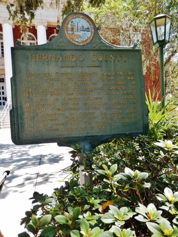
On North Main Street north of Broad Street (U.S. 98), on the right when traveling north.
Hernando County originally embraced Hernando, Pasco and Citrus counties. It was created by the Territorial Legislature in 1843 and named for Hernando DeSoto. In 1844 its name was changed to Benton County in honor of Senator Thomas Hart Benton of . . . — — Map (db m123567) HM
Near Sand Hollow Road near Lytle Boulevard, on the right when traveling north.
John D. Henderson was the third child of twelve born to Perman D. and Sarah (Trapp) Henderson, both originally of Tennessee. John was born December 30, 1828, in what is now part of downtown Kansas City, then farmland, where his parents had . . . — — Map (db m107039) HM
On N. Old Wire Road (County Road 67) 1.5 miles north of Gann Ridge Road, on the right when traveling north.
On the Arkansas—Missouri line where the Telegraph Road entered ten-mile long Cross Timber Hollow, on February 16, 1862, occurred the first skirmish on Benton County soil. Brig. Gen. Curtis’ Federal army overtook the rear guard of Maj. Gen. . . . — — Map (db m99705) HM
On South 1st Street north of West Elm Street, on the right when traveling north.
To commemorate the Centennial passage, through Benton County of the First Westbound Stage coach on the Butterfield Overland Mail Route from St. Louis to San Francisco. Callahan's Tavern, the site of which is about a half a mile northeast of this . . . — — Map (db m216324) HM
On 1st Street North just south of 3rd Avenue North, on the right when traveling north.
Minnesota Territory 1849-1858On March 3, 1849, during his last hours in office. President James K. Polk signed a bill adding a new name to the American political landscape — Minnesota Territory. A vast land, it stretched from the St. . . . — — Map (db m205213) HM
Near Missouri Route 5 at Katy Trail, on the right when traveling south.
Ezekiel (Zeke) Williams, “Grandfather of the Santa Fe Trail,” was born in Hampshire County
West Virginia, to David and Sarah Denton Williams. The family soon moved to Kentucky. He was
married in 1795 and had a son. His wife's name is unknown. Zeke . . . — — Map (db m252446) HM
On West Front Street west of Elm Street, on the right when traveling west.
Washington Railroad Depot Burns
Confederate General Marmaduke's forces were advancing on Washington as October 1864 approached, with fear and widespread panic among the town's residents. Many citizens crossed the river to evade the advance of . . . — — Map (db m239173) HM
On Jackson Street south of McClure Avenue (County Road 923), on the right when traveling south.
The St. Louis & San Francisco Railroad was established
in 1881. Lowell was a village at that time. The 1889 Goodspeed's History of Benton County says greens, fruits, poultry, timber and railroad ties shipped extensively from the depot. The . . . — — Map (db m93263) HM
On SW Madison Ave at SW 8th St, on the right when traveling west on SW Madison Ave.
Fred J. Porter was the great-grandson of Benton County pioneer, Johnson Mulkey.
In the winter of 1845, Mulkey filed a land claim for 640 acres along Oak Creek, on the north side of Baldy Mountain. This was only a few months after Joseph Conant . . . — — Map (db m117266) HM
On North Main Street at East Central Avenue (State Highway 72), on the right when traveling north on North Main Street.
The Osage Nation first used the area now known as Bentonville for their hunting grounds. The Osage would leave their settlements to hunt in present day Benton County for months at a time before returning to their families. Settlers first . . . — — Map (db m237837) HM
On Fair Avenue east of Arkansas Highway 59, on the right when traveling east.
Founded in 1889 has been entered into the National Registry of Historical Places by the United States Department of the Interior on 7-8-99. — — Map (db m224982) HM
On Pearl Street (County Road E36) at Jones Street East, on the right when traveling south on Pearl Street.
Built in 1915 by the Iowa Highway Commission. Placed on the National Register of Historic Places in 1998. Retired to pedestrian duty in 2023. To see a video on the history of the bridge and to learn more, scan the code at left or visit . . . — — Map (db m291687) HM
Thin black lines indicate changes in relevance. Between each pair of lines entries are ordered geographically but all have the same relevance.
* Inflectional forms of words are their plurals, singulars, and possessives as well as gramatical tenses and similar variations.