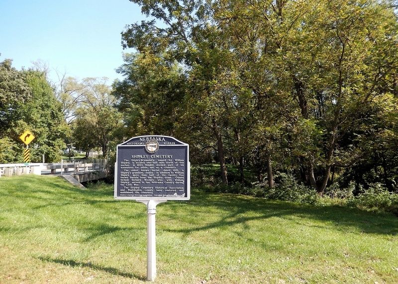
On Ponca Road at North 47th Street, on the right when traveling east on Ponca Road.
The Shipley Cemetery, named for William Shipley, is located one-half mile north of this marker. In 1893 Shipley deeded part of his homestead for public use as a cemetery. The oldest known burial, dated 1861, is Shipley’s grandson, James. In . . . — — Map (db m287973) HM
On Metro Tech College Road (West Road) at Metro Tech College Road (North Road), on the left when traveling north on Metro Tech College Road (West Road).
On April 27, 1875, General George A. Crook assumed command of the Department of the Platte, which then included Iowa, Nebraska, Wyoming, Utah, and part of Montana and Idaho. When the headquarters was shifted from downtown Omaha to Fort Omaha (Omaha . . . — — Map (db m223451) HM
Until after World War I, no other method equaled a soldier’s ability to send intelligence information directly to the ground by telephone from an observation balloon.
Fort Omaha entered America’s balloon and aviation history in April 1909 when . . . — — Map (db m58151) HM
On East Road at South Road, on the right when traveling north on East Road.
Originally a filtration plant constructed in 1912, this building was remodeled and enlarged to become the Post Exchange Building in 1923. All incoming or outgoing calls, whether emergency or routine, would pass through the Post switchboard housed . . . — — Map (db m58118) HM
To maintain discipline among a large garrison, Fort Omaha commanders strictly followed the military code of the frontier era. Facing occasional problems with drunkenness, insubordination, fighting and desertion, officers were quick to punish . . . — — Map (db m58122) HM
Constructed in 1906, this double barracks building housed noncommissioned officers of the U.S. Army Signal Corps, which had reactivated Fort Omaha in 1905. During World War I, this building served as South Post Headquarters for the Army’s first . . . — — Map (db m58106) HM
Maintaining the health and well-being of soldiers at Fort Omaha was accomplished only after overcoming serious obstacles.
One such obstacle was the shortage of potable water. By 1869 only two of the Fort’s wells were considered safe for . . . — — Map (db m58090) HM
During World War I, citizen participation in relief and aid societies was exceptional across America. Omaha’s Red Cross chapter led all cities in the country in per capita membership.
In addition to the Red Cross providing a canteen at Fort . . . — — Map (db m58149) HM
On West Road at Middle Road, on the left when traveling north on West Road.
Built in 1906, Fort Omaha’s “Officers Row” typifies the architecture appropriate for officers’ residences on an army post in the early 20th century. Large and impressively formal, the houses lack elaborate exterior decoration . . . — — Map (db m58156) HM
In 1880, nearly a dozen years after Fort Omaha was established, indoor hot and cold water bathing facilities were installed – three shower rooms for enlisted men and one for officers. By the end of the 19th century a new attitude towards the . . . — — Map (db m58120) HM
Even after the 1869 completion of the transcontinental railroad, the Army relied on mules and wagons to outfit its isolated posts. The Department of the Platte, headquartered at Fort Omaha, paid over $700,000 to acquire and transport troops and . . . — — Map (db m58107) HM
Upon the recommendation of Lt. General William T. Sherman, in 1866 the Adjutant General’s office created the Department of the Platte which included present-day Iowa, Nebraska, Wyoming, Utah, Montana and a portion of southeastern Idaho. As . . . — — Map (db m58154) HM
On Middle Street, on the left when traveling west.
As a result of a major confrontation from 1866-1868 between the U.S. Army and the Lakota (Sioux), the U.S. government signed a treaty agreeing that the Army would abandon several posts along the Bozeman Trail. By this time, the Union Pacific had . . . — — Map (db m58157) HM
After nine years of inactivity, Fort Omaha reopened in 1905 as a school for noncommissioned Signal Corps officers. A structure to house the army’s only dirigible (balloon airship) was completed in 1908, and the first dirigible flew in April 1909. . . . — — Map (db m58150) HM
On the Alley between 2nd and 1st Roads, on the left when traveling north.
This small, tin-roofed building hardly suggests its central role in the mission of the officers and troops once stationed at Fort Omaha. Constructed in 1883-84, the ordnance magazine was the chief storage place for weapons and ammunition.
It was . . . — — Map (db m58117) HM
Throughout the frontier era, the Quartermaster’s Department oversaw post construction, supply procurement and transportation. It worked closely with the Subsistence Department which purchased and assigned rations. To both agencies, Fort Omaha . . . — — Map (db m58131) HM
On Farnam Street west of 17th Street, on the left when traveling west.
Lynching in America
After the Civil War, an ideology of white supremacy persisted as many Americans still believed in racial hierarchy. Violent resistance to Black equality ushered in an era of racial terrorism where more than 6,500 Black . . . — — Map (db m264855) HM
Near Bennington Road (State Highway 36) 0.4 miles east of North 96th Street, on the right when traveling east.
This 160-acre farm, most of which is now a lake and recreational area, was once home to three generations of Boettgers: William A. and Mina Stuhr Boettger, Otto M. and Irene Grau Boettger, Robert D. and Nadeen Preston Boettger. Homesteaded by Isaac . . . — — Map (db m287958) HM
On Robert H. Storz Drive south of Underwood Avenue.
Erected by the people of Douglas County to honor the men and women of this county who gave their lives in World War II
In Memorium
Abel, Charles E. · Adams, Robert S., Jr. · Abrahamson, Philip · Adler, Emil L. · Aguilera, Harold C. · . . . — — Map (db m266551) WM
On Dodge Street west of Farnam Street, on the right when traveling west.
The story of the Dodge Street Pedestrian Overpass began with parents' concern about the safety of their children walking to school. Responding to post-World War II growth in student population and requests from parents, the City of Omaha began . . . — — Map (db m265937) HM
Born in Virginia in 1824, James Megeath was the eldest of 10 children. By age 20, he had become a cattle and sheep trader. Struck by gold fever, he went to Calaveras County, California, in 1851, operating a general merchantise store for three . . . — — Map (db m58234) HM
Johan Ahmanson was born on April 7, 1827, in Smaland, Sweden. At age six he was taken to live with a farmer, for whom he worked until age eighteen. He became a master bookbinder and emigrated to Denmark in 1849. There he was recruited by the . . . — — Map (db m58207) HM
On U.S. 59 at East 6th Street, on the left when traveling east on U.S. 59.
This place holds many meanings to the many peoples who have called this region home. Through the 1700s, this area was part of the Kanza (today known as the Kaw Nation) homeland where they lived, farmed, and traded in towns along the Missouri . . . — — Map (db m287468) HM
On Riverfront Drive, on the left when traveling south.
This Union Walk is a reminder to all of our citizens, as well as a salute to the unionized men and women from all walks of life, who invested their energy, the sweat of their brow, and sometimes even their lives to forge a better life for . . . — — Map (db m63498) HM
On Robert H Storz Drive 0.2 miles south of Underwood Avenue, on the right when traveling south.
Located at the highest point in Memorial Park, the World War II Memorial Shrine recognizes the men and women of Douglas County, Nebraska, who lost their lives while serving in the war.
The shrine is a semi-circular colonnade of seven arches. . . . — — Map (db m270015) HM
Thin black lines indicate changes in relevance. Between each pair of lines entries are ordered geographically but all have the same relevance.
* Inflectional forms of words are their plurals, singulars, and possessives as well as gramatical tenses and similar variations.