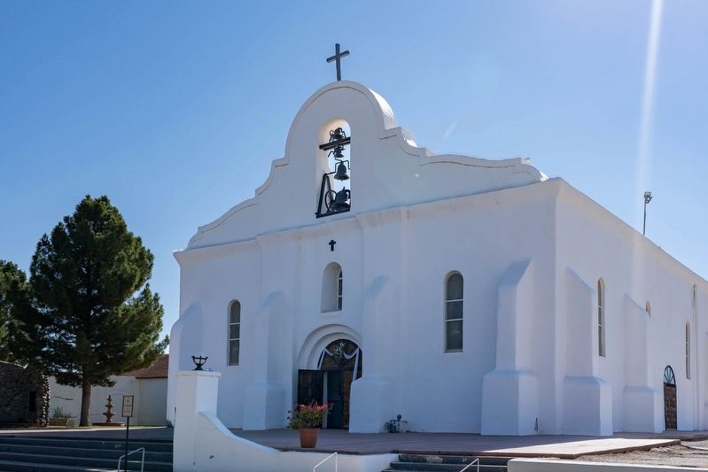
On San Elizario Road at Church Street, on the left when traveling west on San Elizario Road.
Spain sought to protect its interests in the northern frontier by establishing a network of presidios (fortresses). A presidio was built in 1684 in El Paso del Norte (Ciudad Juárez). In 1789, a presidio named after Saint Elzéar (San Elcear in . . . — — Map (db m289873) HM
Near Farm to Market Road 61 south of Thompson Road.
As Indian agent, forceful peacemaker and humanist, Maj. Neighbors had more influence over Texas’ Indians than any other man of his era; came to Texas in 1836.
He served as quartermaster in Texas Army, 1839-41. While on Texas Ranger duty in San . . . — — Map (db m93515) HM
On Calle De Parian, on the left when traveling east.
On July 24, 1861, Lt. Col. John Robert Baylor led 300 men consisting of two companies of the Second Texas Mounted Rifles, a Texas light-artillery company without its howitzers, an El Paso County scout company, and some civilians from Fort Bliss to . . . — — Map (db m38266) HM
On Main Street south of Glorietta Road, on the right when traveling south.
On January 3, 1850, El Paso County was created by the Texas Legislature. San Elizario, the most prosporus and largest town in the area became the first County Seat. The building before you was chosen to house the first Jail. The Commissioners Court . . . — — Map (db m195510) HM
On North Rio Vista Road, on the left when traveling east.
English:
El Paso County's second poor farm, known as the El Paso Poor Farm, was established here in 1915. John O'Shea, a wealthy farmer and businessman whose farm was nearby, assumed operation of the farm. His wife, Agnes . . . — — Map (db m201953) HM
On Interstate 10 at milepost 138, 2.5 miles west of West Broadway Street, on the right when traveling west.
Formed from El Paso County; Created March 10, 1911; Organized April 18, 1911; Named for David B. Culberson 1830-1903 famous constitutional lawyer, a Confederate officer, member of the Texas legislature, member of the United States congress; Van . . . — — Map (db m43479) HM
On South Nevarez Road at Winn Road on South Nevarez Road.
Socorro (Spanish for "help" or "succor") took its name from Socorro, New Mexico, the home of the Piro natives, some of whom accompanied the Spaniards as they headed south to El Paso del Norte following the Pueblo Revolt of 1680. Records show that . . . — — Map (db m288208) HM
On Alameda Avenue at Dorbandt Circle on Alameda Avenue.
Ysleta High School, built in 1929, is one of El Paso County’s oldest secondary schools and the first built by the Ysleta School District to serve the Lower Valley farming communities. Designed by the renowned architectural firm Trost & . . . — — Map (db m248866) HM
On Scenic Drive, on the right when traveling east.
El Paso Lower Valley Missions
Ysleta Mission -- 1681. Ysleta, the oldest community in Texas, claims the most steadily cultivated plot of land in the U.S.
Socorro Mission -- 1682. Regarded as the oldest active parish church in the . . . — — Map (db m37890) HM
On Main Street at Alarcon Road, on the left when traveling east on Main Street.
This structure was built about 1850 of adobe bricks (sundried mud and reeds) and cottonwood logs around steel cell blocks. It served as official county jail 1850-66 and 1868-73, when San Elizario was the first and then third El Paso County seat. It . . . — — Map (db m118272) HM
On South Old Pueblo Drive south of Alameda Avenue (Texas Highway 20), on the left when traveling north.
Although the exact building date for this adobe masonry structure is unknown, it appears to have been constructed during the 1870s for Benigno Alderete (1845-1916). Born in Ysleta (now part of El Paso), Alderete served at various times as a Texas . . . — — Map (db m37981) HM
On West Mills Avenue at South El Paso Street, on the right when traveling west on West Mills Avenue.
Inhabited by various Indian tribes prior to the arrival of the Spaniards in the 16th century, El Paso has played an important role in the history of Mexico and the United States. Its four centuries of recorded history span periods of Spanish . . . — — Map (db m305425) HM
Livestock shows and rodeos have a grand heritage in
Texas. Drawing from traditions of Hispanic vaqueros and western cattle drives, organized competitions in the state date from the 1880s, with the first documented El Paso
Rodeo occurring . . . — — Map (db m249030) HM
On Sierra Blanca Avenue (Ranch to Market Road 1111) at El Paso Street (Business Interstate 10), on the right when traveling north on Sierra Blanca Avenue.
Formed from El Paso County
Created February 16, 1917
Organized August 25, 1917
Named in honor of
Claude Benton Hudspeth
Born in 1877
A native Texan
Holder of larger ranching interests
Member of the Texas Legislature
and the . . . — — Map (db m118227) HM
Thin black lines indicate changes in relevance. Between each pair of lines entries are ordered geographically but all have the same relevance.
* Inflectional forms of words are their plurals, singulars, and possessives as well as gramatical tenses and similar variations.