Near Ford Road/4 Mile Road (Kentucky Route 1924) 1.2 miles south of Boonesboro Road ( Route 627), on the left when traveling south.
The Front Moves South
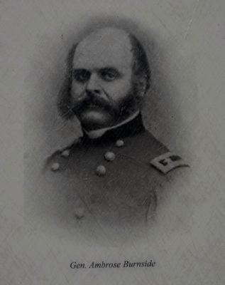
Capt. Thomas Brooks' plan for the defense of the Kentucky River was never completely realized. The reason lies in the shifting fortunes of war. In 1863, General Ambrose Burnside was sent to Kentucky to lead an . . . — — Map (db m74645) HM
On Quail Run Drive at Kelly Avenue, on the right when traveling south on Quail Run Drive.
Payne-Desha House. Built ca. 1814-15 by Robert Payne, a veteran of Battle of the Thames in War of 1812. Former Kentucky Governor Joseph Desha bought the Federal-style stone house in 1841. In late 19th century, Italianate alterations to . . . — — Map (db m91634) HM
On East Walnut Street near Elm Street, on the right when traveling east.
Shields, born 1769 in Virginia, served as a private for the entire Lewis and Clark Expedition from October 19, 1803 until October 10, 1806; one of its "Nine Young Men from Kentucky," he was a skilled gunsmith and blacksmith.
The Corps of . . . — — Map (db m9642) HM
On Old Indiana 135, on the right when traveling south.
Civil War cannon has been dedicated to the memory of Arville L. Funk: historian, author, lawyer, teacher, civic and church leader
This six-pound field gun is similar to those used by General John Hunt Morgan’s Raiders and the Harrison County . . . — — Map (db m9687) HM
On Rockmartin Drive, on the right when traveling west.
In 1844, Harrison C. Marsh (1805-1889) and his wife, Mary "Polly" (Raymond) (1810-1888), natives of Harrison County, Kentucky, came from Independence, Missouri to Texas with their five children. They settled in Peters Colony on Farmers Branch . . . — — Map (db m148678) HM
On Elysian Fields Road (Farm to Market Road 31) at County Road 1004, on the right when traveling north on Elysian Fields Road.
Kentucky native W. F. Rocker founded the Marshall Pottery in 1895. The locale, apparently not legally owned by Rocker, contained spring-fed water and vast quantities of white clay, the two natural ingredients needed for the production of pottery. . . . — — Map (db m293941) HM
Near Old State Road 135 south of West Heidelberg Road NW, on the right when traveling south.
On July 9, 1863, along this wooded ridge - - - from the “Laconta” Road extending across the “Mauckport” Pike to the old “New Amsterdam” Road - - - occurred the only Civil War battle in Indiana. It was between Gen. John Hunt Morgan’s Confederate . . . — — Map (db m9721) HM
Near Squire Boone Road Southwest near Pleasant Grove Road Southwest.
Into this cave opening Squire Boone escaped pursuing Indians about 1790. Thereafter he considered the cabe holy ground. At his request, he was buried in this cave in a walnut coffin hewn from native timber by his own hands. At the time of his . . . — — Map (db m205362) HM
On West High Street, on the right when traveling west.
Corydon’s Constitution Elm stood a few
blocks to the north of Indiana’s first capitol.
The huge elm tree, about 50 feet high and
spread over 130 feet, offered cooling shade
from the summer sun. When the framers
of the Indiana Constitution met . . . — — Map (db m137628) HM
On South Main Street (U.S. 27), on the right when traveling south. Reported damaged.
Rebel Raider John Hunt Morgan's two famous Kentucky raids in 1862 and 1864 included significant engagements with Union forces at Cynthiana. Morgan's mission was to destroy railroad facilities, disrupt communications, acquire supplies, recruit, . . . — — Map (db m218101) HM
On Dry Fork Road (County Route 8) at Ohio Route 150, on the left when traveling south on Dry Fork Road.
By July 25, 1863, Brigadier General John Hunt Morgan and his Confederate raiders knew that their pursuers were closing in. Major General Ambrose Burnside, directing the Union
pursuit from his Cincinnati headquarters, decided to change his . . . — — Map (db m173473) HM
On East Cherry Street near North Elm Street, on the right when traveling east.
Marker Front
In Honor of
The men from
Harrison County
killed or died of wounds at the
Battle of Tippecanoe
Nov. 7, 1811
and
War of 1812
Marker's Left Side
Capt. Spier Spencer’s Co.
Mounted Rifleman . . . — — Map (db m9751) HM
On Summit Street west of Hill Street, on the right when traveling east.
Facility built 1891 as elementary and secondary school for African Americans. Originally known as Corydon Colored School; first graduation was on May 14, 1897.
Renamed 1987 for Leora Brown Farrow, a teacher at the school, 1924 - 1950. . . . — — Map (db m9627) HM
On West Penn Street at County Road 1004, on the right when traveling west on West Penn Street.
School named for Benjamin Banneker
Principals were
W. E. Newsom
E. O. David
Consolidated with
Harrison County School System 1963 — — Map (db m218105) HM
Thin black lines indicate changes in relevance. Between each pair of lines entries are ordered geographically but all have the same relevance.
* Inflectional forms of words are their plurals, singulars, and possessives as well as gramatical tenses and similar variations.