On Second Street at Court Street, on the right when traveling east on Second Street.
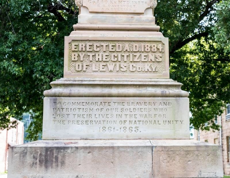
Erected A.D. 1884, by the Citizens of Lewis County Kentucky to commemorate the bravery and patriotism of our soldiers who lost their lives in the War for the Preservation of National Unity. 1861–1865.
One Country and One Flag • . . . — — Map (db m180465) WM
On Kentucky Route 9 at Route 989, on the left when traveling west on Kentucky Route 9.
Site of one of the most popular
health resorts along Ohio River,
1845-60, seven miles west. Mineral
water from spring widely used for
medicinal purposes. Resort was
easy of access by boat and drew
many out of state guests until
destroyed by . . . — — Map (db m146849) HM
On Second Street at Main Street, on the right when traveling west on Second Street.
The New Carter House, built in 1897 by Thomas
Carter, was originally three stories high with a
wrought-iron gallery on the two street sides. It
caught fire in the 1920s but was not completely
destroyed. The building was purchased by Max
Block, . . . — — Map (db m180439) HM
On 3rd Street just west of Main Street, on the left when traveling west.
The Commercial Hotel was originally the
home of Judge George Morgan Thomas
and his family when it was built in 1883.
Judge Thomas served as a U.S. Senator
from this district and also acted as a
Solicitor of Internal Revenue, After the
Thomas . . . — — Map (db m180269) HM
On Second Street at Market Street, on the right when traveling east on Second Street.
These two buildings were the original structures of the
Deposit Bank of Vanceburg and the New York Racket
Store. The Bank was established about 1889 and this
building was erected of freestone in 1900. The Bank
merged with the Citizens Bank later . . . — — Map (db m180436) HM
On 3rd Street at Main Street (Route 2525), on the right when traveling east on 3rd Street.
This home, built in 1856, was the home of
Judge William C. Halbert and his wife,
Lavina. Mr. Halbert was a well-known
attorney and served in several political
offices. Throughout the years the house
has been owned by several of his
descendants. — — Map (db m180266) HM
On Second Street east of Main Street, on the right when traveling east.
This building, made of native Freestone,
was built some time between the 1800s and
1870s. It has been a jewelry store, a drug
store, and a billiard hall at different times.
During the 1913 flood, Max Block operated
a clothing store here and . . . — — Map (db m180440) HM
On Main Street at Second Street, on the left when traveling north on Main Street.
This row of buildings is often referred to as the
“Stamper Block” because George W. Stamper, a
prominent merchant owned most of these buildings at
one time or another. The majority of the buildings were
built in the 1870-1880 era. This corner . . . — — Map (db m180437) HM
On Second Street east of Market Street, on the left when traveling east.
Prior to 1866 there were few Methodists in
Vanceburg, and they had no house of worship.
Rev. Jerry Lennen (or Lenner) was sent by the
Conference in 1866 to hold services in the school
and city hall. Lenner and Rev. Alfred Harrison
worked . . . — — Map (db m180285) HM
On Main Street at 3rd Street, on the left when traveling north on Main Street.
The railroad was known originally as the
Maysville and Big Sandy Railroad. The first
depot was built on this site shortly after the
railroad was completed in 1888 on land
belonging to Lyman B. Baird, a son-in-law of
Judge William C. Halbert. . . . — — Map (db m180271) HM
On Second Street at Court Street, on the right when traveling east on Second Street.
In memory of those who gave their lives for their country in World War II, 1941–1945
U.S. Army. Armstrong, Ermal E. • Armstrong, James • Bloomfield, Carlen • Bodkins, James I. • Brewer, Homer C. • Bruce, Alexander T. • Bunch, Leland O. • . . . — — Map (db m180463) WM
Squire Bozorth 1792-1853
Cowlitz County Kentucky Militia
•
George Bush 1789/90-1863
Thurston County Kentucky Militia
•
Asa Coombs 1796-1888
King County Tennessee Militia
•
Walter Crockett 1786-1869
Island County . . . — — Map (db m308907) WM
On W Tom T. Hall Boulevard (U.S. 60) at Route 2078, on the right when traveling west on W Tom T. Hall Boulevard.
Created from parts of Carter,
Lewis and Elliott Counties with
county seat here by legislative
act signed Feb. 9, 1904, by Gov.
J.C. W Beckham for whom it was
named. C. C. Brooks appointed
County Judge. On April 29, 1904,
the Court of Appeals . . . — — Map (db m145288) HM
Near Kentucky Route 114 0.1 miles east of Route 404, on the right when traveling east.
Son of a Frankfort lawyer, Monroe led the charge which decided the battle's outcome. He and his regiment later saw action at Chickasaw Bluffs, Arkansas Post, Champion Hill, Thompson's Hill, and other important battles. In 1864 Monroe assumed command . . . — — Map (db m69141) HM
On State Highway JJ 0.6 miles south of State Highway Z, on the right when traveling north.
The July 28, 1862, Battle of Moore's Mill opened about one-eighth mile south along the Moore's Mill-Galbreath Mill road, near today's State Road JJ. This area then was heavily timbered.
Lying in ambush east of the road were about 260 . . . — — Map (db m207957) HM
On Second Street at Court Street, on the right when traveling east on Second Street.
The only Union monument south of the Mason-Dixon line erected by public subscription except those in cemeteries. This unique memorial was dedicated in 1884 to the 107 Lewis County soldiers who gave their lives for the Union during the Civil War. — — Map (db m180371) HM
Mexico and Audrain County have some rich history, tied into the Civil War. This area was of vital strategic importance to both sides, politically and militarily, during the War. Politically, Southern sympathies ran deep in this area, the heart of . . . — — Map (db m288549) HM
Thin black lines indicate changes in relevance. Between each pair of lines entries are ordered geographically but all have the same relevance.
* Inflectional forms of words are their plurals, singulars, and possessives as well as gramatical tenses and similar variations.