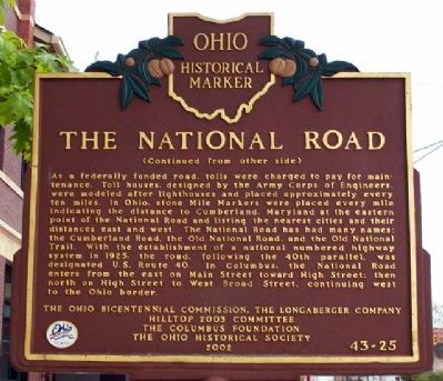
On Broad Street at Wheatland Avenue, on the right when traveling west on Broad Street.
Side A:
After the Revolutionary War, our first President, George Washington, advocated the construction of a road linking cities in the United States from east to west. In 1806, President Thomas Jefferson signed legislation authorizing the . . . — — Map (db m34082) HM
On Plain City-Georgesville Road (Ohio Route 142) 0.2 miles south of Morgan Road, on the right when traveling north.
Seven-year-old Jonathan Alder was captured by a Native American war party in Virginia in 1782 and taken to a Mingo village north of the Mad River in Ohio where he was adopted by an Indian family. He remained with the Indians until after the 1795 . . . — — Map (db m40193) HM
On Lauderdale Street west of East Street (County Road 71), on the right when traveling west.
The town owns the Brick Church, the Stagecoach Tavern, and the Post Office.
One of the town's primary budget lines is the care and maintenance of these historic public buildings for future generations.
However, these structures would not be . . . — — Map (db m189570) HM
On Ohio Route 29 at Route 560, on the left when traveling west on Ohio Route 29.
(bronze plaque)
Richard Stanhope
(Stanup)
Free black man and landowner
Settler in Madison County, Ohio
on Virginia Military land
resident of Concord Township
Champaign County, Ohio
Died September 1862
Buried in Concord . . . — — Map (db m106683) HM
On Main Street (Ohio Route 56) at High Street (U.S. 42), on the left when traveling north on Main Street.
In recognition of the patriotism of the people of Madison County who oversubscribed their War Saving Quota in 1918 this tablet is gratefully erected by the Ohio War Savings Committee — — Map (db m53903) HM
On Raymond Road (County Route 191) 1 mile north of U.S. 33, on the left when traveling north.
Following the American surrender of Fort Detroit in August 1812
panic spread along the Ohio frontier in fear of possible Indian
attacks. The boundary of the Indian territory lay approximately
14 miles to the north at the Greenville Treaty . . . — — Map (db m75187) HM
On West Main Street (U.S. 40), on the right when traveling west.
In 1831, Congress passed a bill appropriating money for the extension of the Cumberland Road through Ohio, Indiana and Illinois. In 1836-37 this great National Road was completed through Madison County.
At the beginning of the 19th Century, hardly . . . — — Map (db m96977) HM
On National Road West (U.S. 40) west of Oak View Road, on the right when traveling west.
The Brick Tavern, also known as the "Brick Tavern House," "The Tavern Stand," and "Lentz Tavern" is a Greek Revival example of a roadside inn built circa 1828 by Samuel Robinson. This tavern is one of a handful of known structures still standing . . . — — Map (db m247961) HM
On West 18th Street at Baynard Boulevard on West 18th Street.
African American Medal of Honor Recipients Memorial
The Medal of Honor takes its place in our country as the highest award for military valor. The honor, awarded by the President in the name of Congress, may only be accorded an . . . — — Map (db m173924) HM WM
On West 5th St. at Court Street, on the right when traveling east on West 5th St..
Union County, Ohio
Union County, Ohio, was established on April 1, 1820. The county was
created from the "union" of portions of Delaware, Franklin, Logan,
and Madison Counties, and a section of former Native American
territory. The first . . . — — Map (db m93552) HM
On Cliff Park Road, on the right when traveling east.
This memorial is dedicated to the men from Clark County, Ohio who died while serving their country in the Vietnam War. Their sacrifices will never be forgotten.
Steven J. Adams •
William R. Adams •
Steven Randerson •
James R. Arthur • . . . — — Map (db m214546) WM
Side A:
Augustus West, an African American, was born in Madison County, Virginia on March 20, 1814, and moved to Ohio in 1837. Legend has it that West was a runaway slave and worked as a farm laborer before designing a scheme to purchase his . . . — — Map (db m28631) HM
Near Mounds Road (State Road 232) 0.4 miles south of Markleville Road (County Road S300E), on the right when traveling south.
The Bronnenbergs represent true pioneer spirit and a preservationist ethic.
Frederick Brandenburg was born in 1775 in Germany. As a youth he apprenticed as a tanner. Brandenburg immigrated to America as a young man, changing his name to . . . — — Map (db m163062) HM
On Norfolk Street at Washington Street, on the right when traveling south on Norfolk Street.
Lewis and John Milton Clarke, who were among the many contributors to the antislavery cause in Cambridge, were born in Madison County, Kentucky. They were the sons of an elderly white Revolutionary War veteran and a mulatto daughter of Samuel . . . — — Map (db m215275) HM
On Adams Lane near State Route 467, on the left when traveling south. Reported missing.
As the Civil War moved into the Deep South, many people
fled the shifting war front. Two coinciding events encouraged
Henry Coker to become a refugee: the death of his wife and the
approach of the Union navy, steaming up the Mississippi . . . — — Map (db m109563) HM
On SE Madison Drive south of West Jackson Street, on the right when traveling south.
Like many communities, Ridgeland's
early growth was due in large part to
the presence of the railroad. Access to
an existing railroad greatly influenced
Edward Treakle and Gorton Nichols of the
Highland Colony Company to develop
the fertile . . . — — Map (db m259544) HM
Thin black lines indicate changes in relevance. Between each pair of lines entries are ordered geographically but all have the same relevance.
* Inflectional forms of words are their plurals, singulars, and possessives as well as gramatical tenses and similar variations.