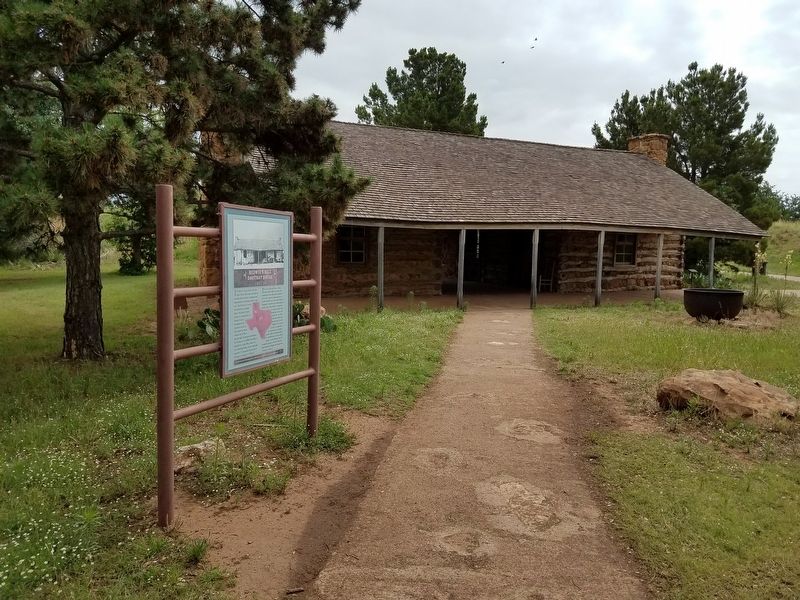
In Mason County, Texas, near the Llano River, this house was built as two log cabins under a common roof separated by a breezeway called a dogtrot. The limestone rooms in the back were added later. The style of architecture is characteristic of . . . — — Map (db m135407) HM
On West 35th Street west of Main Street, on the right when traveling west.
Famed defender of the frontier. Instilled ideals of excellence into Texas Rangers.
Born in South Carolina. Came to Republic of Texas 1839. Educated at Old Baylor and Rutersville, where students had to defend school from Indian attacks.
In . . . — — Map (db m170031) HM
On West Austin Street 0.1 miles west of North Crockett Street, on the left when traveling west.
This home was built in 1872-73 by German immigrant Heinrich Bierschwale, a teacher in the rural schools of Gillespie and Mason counties. He later served as county and district clerk in Gillespie County. The two-story stone vernacular house . . . — — Map (db m163966) HM
On Lower Willow Creek Road 0.2 miles south of State Highway 29, on the right when traveling south.
Originally this was the area's second Methodist Church. Built of native stone and lumber by the pioneers in 1875, after a fire destroyed an 1858 church and school structure. Rocks were plastered over about 1938.
After the 1890's this building was . . . — — Map (db m237408) HM
On Austin Street (State Highway 29) at N. Art Road, on the right when traveling east on Austin Street.
Heinrich Conrad Kothmann (1798-1881) and his wife Ilse Katherine Pahlmann (1810-1905) and their family sailed from Germany to Indianola, Texas in 1845. Among the first families to settle in Fredericksburg, the Kothmanns were issued a 640 acre land . . . — — Map (db m44445) HM
Near Loeffler Lane 0.2 miles east of Ranch to Market Road 783.
Built 1862. Second church of any faith in Mason County. Housed first school in the county. Recorded Texas Historic Landmark - 1965 — — Map (db m91747) HM
On San Antonio Street (U.S. 87) at Westmoreland Street, on the left when traveling north on San Antonio Street.
(front side)
Fort Mason, located 5 blocks south, was headquarters for the first regiment Texas Mounted Rifles 1861-62. These Confederate troops occupied the line of old U. S. forts to give protection against Indians.
215 . . . — — Map (db m118232) HM
On Fort McKavett Street (U.S. 87) at Broad Street, on the right when traveling east on Fort McKavett Street.
Constructed in 1909, this is the third courthouse to serve the people of Mason County. Commissioners Court probably met in other locations until the first courthouse was built in 1872. It burned in 1877 and was replaced that year by a second red . . . — — Map (db m118894) HM
Near Ranch to Market Road 2389 0.9 miles south of Ranch to Market Road 1723, on the left when traveling south.
Born in Mississippi, Dizenia Peters moved to Texas with her parents about 1835. She married William P. Smith in 1844, and had a son, James. After Smith’s death, she married George W. Todd (1827-1901) in 1851; they had 3 daughters. Todd and members . . . — — Map (db m91933) HM
On County Highway 4226 0.4 miles east of County Highway 4127, on the left when traveling east.
Dedicated and courageous. Born in Indiana; reared in Missouri. Wounded twice in Confederate service during the Civil War.
On reorganization of Texas Rangers, 1874, was commissioned first lieutenant; promoted 1875 to captain, Company A, official . . . — — Map (db m108537) HM
The remains of this noted gunman and outlaw lie here. A teamster traveling from West Turkey Creek found the body sitting in the fork of a nearby oak tree with a bullet hole in the right temple.
A coroner's jury reported the death to be suicide, . . . — — Map (db m28365) HM
On Fort McKavitt Street (State Highway 29) 0.1 miles east of North Robin Ave, on the right when traveling west.
Attorney Henry Holmes (1836-1895) moved to Mason after serving in the U.S. Army and continued his public service as county attorney, justice of the peace and personal secretary to Gov. Lawrence Sullivan Ross. About 1883 he had this sandstone . . . — — Map (db m237349) HM
On North Spring Street 0.1 miles north of Bluebird Street, on the left when traveling north.
Tom Lindsay settled in Mason County during the 1860s and was a farmer and cattle raiser north of the town of Mason. About 1899 he and his wife, Fredericka (Durst), moved into town and built this house. It features fine stonework, particularly in the . . . — — Map (db m237336) HM
Born on September 15, 1839 in Mason County, Kentucky on the plantation of Benjamin Gratz, Lawson Gratz worked as a farmer for his owner prior to the Civil War. Lawson was directed by his owner to enlist in the Federal army on July 24, 1864 at . . . — — Map (db m189460) HM
On Ranch to Market Road 2323 south of County Highway 110, on the left when traveling south.
Early Llano County leader, Robert Flack (Bob) Rowntree (1847-1893), built this majestic two story house in the Prairie Mountain community from 1875 to 1888. Scottish architect John K. Finlay, a pioneer in the Texas granite industry, designed the . . . — — Map (db m237469) HM
On State Highway 29 at Art Hedwigs Hill Road, on the left when traveling west on State Highway 29.
Organized 1856 by the Rev. C.A. Grote, first minister to preach here. First building was erected in 1858; second one, of stone, in 1875. The present structure was built 1890 on land donated by Ernst Jordan, Sr., charter member. Until 1927, all . . . — — Map (db m237404) HM
On North Art Road 0.5 miles north of State Highway 29, on the right when traveling north.
Cattle brands inspector, killed 1875 by cattle rustlers in Mason County War - a feud between the law and the lawless.
Recorded - 1967 — — Map (db m237405) HM
On U.S. 87 0.5 miles south of Ranch to Market Road 1222, on the right when traveling south.
During the 1850s and 1860s, Mason County landowner “Major” Joshua Peters, supplied cut prairie grasses from here to Fort Mason for their horses. The community which developed took the name Peter’s Prairie. In 1877, John Rhoads and W.H. . . . — — Map (db m90947) HM
On Farm to Market Road 1871 0.1 miles west of South Avenue D, on the left when traveling south.
Named for a victim in famous "Hoodoo War", provoked by cattle rustling in Mason County. John Whorlie (or Worley), a deputy sheriff, on May 13, 1875, lost a prisoner to a lynch mob. On Aug. 10,1875, Whorlie was killed and scalped while working on . . . — — Map (db m237345) HM
On State Highway 29 3.5 miles west of U.S. 377, on the right when traveling west.
Forefathers resisting America's foes on many frontiers inspired John Bate Berry, who came to Texas from Kentucky in 1826. He fought (1835-36) in the Texas War for Independence and in the 1842 Mier Expedition to stop Mexican raids on the Republic of . . . — — Map (db m237346) HM
Thin black lines indicate changes in relevance. Between each pair of lines entries are ordered geographically but all have the same relevance.
* Inflectional forms of words are their plurals, singulars, and possessives as well as gramatical tenses and similar variations.