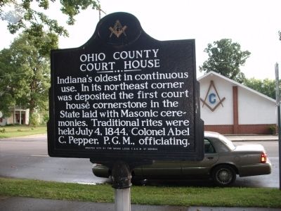
On Main Street (State Road 262) at South Mulberry Street, on the right when traveling east on Main Street.
Indiana’s oldest in continuous use. In its northeast corner was deposited the first court house cornerstone in the State laid with Masonic ceremonies. Traditional rites were held July 4, 1844, Colonel Abel C. Pepper, P.G.M., officiating. — — Map (db m45996) HM
On Main Street (State Road 262) at South Mulberry Street, on the right when traveling east on Main Street.
Dedicated to the memory of those who made the Supreme Sacrifice for their Country and in Honor of those that served in the Armed Forces from Ohio County in all wars — — Map (db m45892) WM
On Main Street (State Road 262) east of South Mulberry Street, on the right when traveling east.
( Veterans Memorial )
( Front - Side )
In Honor of Ohio County Veterans
( Encircling - - Seals - - Branches of the United States Military )
( - United States Flag - )
Dedicated
November 11, 2000
( . . . — — Map (db m45980) WM
On Fourth Street at North Poplar Street, on the left when traveling east on Fourth Street.
African American Samuel Barkshire was freed from slavery in Boone County, Kentucky in 1833. He and his family moved here in 1836. The Barkshires defied fugitive slave laws to provide aid and comfort to those escaping bondage in the South. Their . . . — — Map (db m180716) HM
On South Mulberry Street at Main Street (Indiana Route 262), on the left when traveling south on South Mulberry Street.
Defiance of the Black Codes In 1854, Arthur Barkshire, a freed
African American, was tried, convicted.
and fined here for bringing his wife,
Elizabeth Keith, a Black woman from
Ohio, across state lines in defiance of
the “Black Codes.” . . . — — Map (db m222309) HM
Near North Front Street north of Main Street, on the right when traveling north.
Arrived in Rising Sun in 1815 serving as an Indian Agent, US Marshall for Indiana and a judge. From 1817 to 1843, Pepper succeeded in helping create Ohio County, with Rising Sun as its county seat, by separating it from Dearborn County. — — Map (db m222397) HM
Near South Front Street south of Main Street, on the left when traveling south.
Ohio County was officially formed on January 4, 1844 when the Governor of Indiana approved an act passed by the state's House and Senate. At 87 square miles, Ohio County is the state's smallest county in size. It is also the smallest in population . . . — — Map (db m222412) HM
Near South Front Street south of Main Street, on the left when traveling south.
The Ohio County Courthouse was built in 1845 entirely on donations including the land which was donated by Col. Abel C. Pepper and his wife. It is the oldest courthouse in continuous operation in the State of Indiana. — — Map (db m222415) HM
On U.S. 40 at Shadyside Drive, on the right when traveling west on U.S. 40.
Side A Fulfilling President George Washington's desire to “open wide the gates of the West,” in 1796 Congress authorized the Zane brothers of Fort Henry (at present day Wheeling) to clear a path through the dense woods of Appalachian . . . — — Map (db m13351) HM
On Harrison Avenue at Gieringer Drive, on the right when traveling west on Harrison Avenue.
Confederate Brigadier General John Hunt Morgan's Indiana-Ohio Raid, or Great Raid, from July 2-26, 1863 covered nearly 1,000 miles and penetrated deeper into the North than any other Confederate incursion during the Civil War. The raid was also . . . — — Map (db m225383) HM
On Main Street (Indiana Route 262) east of South Mulberry Street, on the right when traveling east.
At the time Rising Sun was established (1814) it was part of Dearborn County, Local citizen Colonel Abel C. Pepper, who oversaw the removal of the Native Americans from Indiana in 1837, was instrumental in creating Ohio County. After years of . . . — — Map (db m222311) HM
On South Mulberry Street south of Main Street ( Route 262), on the left when traveling south.
This courthouse was built through the determination of early Rising Sun citizens. They sent the intrepid settler Colonel Abel C. Pepper to Corydon, then the state capital, in 1817 to petition the state to form a new county out of Dearborn County . . . — — Map (db m222307) HM
On Springfield Pike (Ohio Route 4) at West Kemper Road, on the right when traveling north on Springfield Pike.
(side 1)
In July 1863, Confederate Brigadier-General John Hunt Morgan led a force of 2,000 cavalrymen across southern Ohio. Morgan's force entered Ohio from Indiana. A chase ensued as Union cavalry pursued Morgan's men across twenty Ohio . . . — — Map (db m133555) HM
On Ohio Route 60 at Greer Road, on the right when traveling south on Ohio Route 60.
In July 1863, Confederate General John H. Morgan led a force of 2,000 cavalrymen across southern Ohio. Morgan's force entered Ohio from Indiana on July 13. A chase ensued as Union cavalry pursued Morgan's men across twenty Ohio counties. Most of . . . — — Map (db m13383) HM
Pioneer area settler John Peter Smith (1831-1901), who donated twenty acres for the establishment of this cemetery, came to Fort Worth from Kentucky in 1853. He served the community as a teacher, clerk, surveyor, and attorney, and became a noted . . . — — Map (db m264153) HM
Founded 1879 by John Peter Smith, one of Fort Worth's first settlers, who became a civic leader, mayor, philanthropist. He gave 20 acres to city; cemetery since enlarged to 100 acres. The area contains three cemeteries: Oakwood, Calvary, Trinity. . . . — — Map (db m264151) HM
On 5th Street west of North Front Street, on the right when traveling west.
Like so many of the early American settlers, John and Jane Fulton, along with their family, traveled the Ohio River via a flatboat in search of a better life. One night in 1798, they pulled on shore to spend the night and upon waking they saw the . . . — — Map (db m201076) HM
On Adams Street at West Water Street, on the right when traveling west on Adams Street.
You are standing where the very first section of bike trail was constructed in the Miami Valley. From this point forward a regional trail network has grown to over 375 miles.
To build the first mile of trail, the City of Troy worked with The . . . — — Map (db m276095) HM
Thin black lines indicate changes in relevance. Between each pair of lines entries are ordered geographically but all have the same relevance.
* Inflectional forms of words are their plurals, singulars, and possessives as well as gramatical tenses and similar variations.