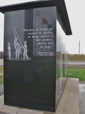
On State Highway 27 at State Highway 29, on the right when traveling south on State Highway 27.
America Will Never Forget
Sept. 11, 2001 · Cadott, WI
Citizen Soldier
"Whether we bring our enemies to justice, or bring justice to our enemies, justice will be done."
George W. Bush
Sept. 20, 2001
. . . — — Map (db m43068) HM
Near West Chippewa Street (County Highway X) 0.4 miles west of Poplar Street, on the left when traveling west.
Lansing A. Wilcox, last surviving Wisconsin veteran of the Civil War, was born in Kenosha March 3, 1846. In February 1864 he enlisted from Chippewa County in F Company, Fourth Wisconsin Cavalry, returning to the Cadott community in 1866. A farmer, . . . — — Map (db m30758) HM
On Wolfe Drive at Irvine Park Drive on Wolfe Drive.
The soldier bird who was captured in Chippewa County by Chief Sky and taken to Eau Claire by Daniel McCann of Eagle Point. With Company "C" of the Eighth Wisconsin Regiment, he participated in twenty-five battles of the Civil War and was afterwards . . . — — Map (db m38223) HM
On East Park Avenue (County Highway J) east of Chippewa Mall Drive, on the left when traveling east.
Before there were numbered highways in the United States there were names attached to roads to help motorists navigate from town to town or from county to county. In 1912 no one thought in terms of an inter-state highway. However, a small band of . . . — — Map (db m42158) HM
On East 1st Avenue east of South Broadway Street (County Highway H), on the right when traveling east.
Before there were numbered highways in the United States there were names attached to roads to help motorists navigate from town to town or from county to county. In 1912 no one thought in terms of an inter-state highway. However, a small band of . . . — — Map (db m42144) HM
On Irvine Park Drive west of Jefferson Avenue (Wisconsin Highway 124), on the left when traveling west.
This waiting shelter at the northern most point of service is the only physical structure remaining of what was once the 12½ mile long Eau Claire/Chippewa Falls interurban electric streetcar line.
In 1897, Boston financier Arthur Appleyard . . . — — Map (db m39822) HM
On East Park Avenue (County Highway J) 0.1 miles west of Industrial Boulevard, on the right when traveling west.
Millions of years ago the Midwest area of North America was covered by a great inland sea that laid down virgin white Cambrian sandstone. As the sea filled in, most of this sandstone became buried thousands of feet below the surface. The rim . . . — — Map (db m42326) HM
On West Grand Avenue west of North Bridge Street, on the left when traveling west.
Built in 1871 by Alexander Wiley Sr. and Nels Elikson, the rooming house over the years was home for hundreds of immigrants, lumber jacks, mill workers, farm hands and log drivers (known as river pigs). In 1887 Wiley Sr. became the sole owner and . . . — — Map (db m42697) HM
On Irvine Park Drive at Bear Den Drive, on the right when traveling north on Irvine Park Drive.
The Bear Den Road Bridge was an example of a Pratt bridge construction, which was a design used in Wisconsin from 1895-1910. The Milwaukee Bridge and Iron Company fabricated the bridge, and it was moved to this site in 1940. The original site and . . . — — Map (db m43065) HM
On Irvine Park Drive west of Bear Den Drive, on the right when traveling west.
The Irvine Park Drive Bridge was an example of a Pratt bridge construction, which was a design used in Wisconsin from 1895-1910. The Milwaukee Bridge and Iron Company fabricated the bridge in 1907. The structure originally crossed Duncan Creek on . . . — — Map (db m38734) HM
On State Highway 27 north of East Mills Street, on the right when traveling north.
In 1880, Captain Ellery Clark of DePere, Wisconsin moved his hub and spoke factory to Cadott. Clark had been a steam boat operator moving logs on the Fox River. He was drawn to the Cadott area because of the high quality and abundant supply of white . . . — — Map (db m48931) HM
On Rushman Drive (State Highway 124) east of Bridge Street, on the right when traveling east.
Hiram S. Allen was born in Chelsea, Vermont and came to the Chippewa Valley of Wisconsin in 1834. Here he began a long and flourishing career and an active business life. He built the first grist-mill, the first flour-mill, and the first hotel . . . — — Map (db m42343) HM
Near Jefferson Avenue (State Highway 124) near Bridgewater Avenue.
Chippewa Fall's oldest industry. In 1867, Jacob Leinenkugel, the son of a Bavarian brewmaster, came to Northern Wisconsin searching for a promising location to build a brewery. He settled on this spot purchasing the land from lumberman Hiram S. . . . — — Map (db m42360) HM
On South Barstow Street at Earl Street, on the left when traveling south on South Barstow Street.
If this were summer 1856, you would be standing in Chippewa County. June 11 that year, the Chippewa County Board gave up this block for a Courthouse Square. So, when Governor Bashford signed the act carving Eau Claire County from Chippewa County on . . . — — Map (db m43485) HM
On West Grand Avenue at Albert Street, on the left when traveling west on West Grand Avenue.
In September of 1873 James Monroe Bingham, a local attorney, State Assemblyman, and future lieutenant governor of the State of Wisconsin, purchased this land which had just been plotted as Block 14 of the Western Addition to the City of Chippewa . . . — — Map (db m42667) HM
On North Bridge Street at West Columbia Street, on the right when traveling south on North Bridge Street.
This building was built in 1917 in memory of Edward Rutledge.
Mr. Rutledge was born in northern Ireland on March 6, 1834. As a child he moved with his parents to South Mountain, Ontario, Canada where they farmed. At age 16 Edward and his two . . . — — Map (db m39426) HM
On West River Street (Business State Highway 29) 0.5 miles west of Wagner Street, on the left when traveling west.
In 1904 on this 25 acre site between the Chippewa River and the Soo Line Railroad tracks, sugar processing became a new industry in the Chippewa Valley. The Chippewa Sugar Company was incorporated and a huge six-story sugar beet factory was . . . — — Map (db m42693) HM
On Island Street south of West Central Street, on the right when traveling south.
As early as 1846, Methodists were meeting in Chippewa Falls, with Thomas Randall preaching to his neighbors in a boarding house owned by the Chippewa Lumber and Boom Company. On March 10, 1860, Reverend Thomas Harwood, the first assigned . . . — — Map (db m42615) HM
On County Highway Q 0.1 miles north of County Highway B, on the left when traveling north.
In the early 1850's, settlers from Rhine, Bavaria, Bohemia, and Luxembourg came to this part of Wisconsin now known as Tilden Township. They vowed to build a church in honor of the "Blessed Virgin Mother of God" giving thanks for their safe voyage . . . — — Map (db m55397) HM
On Oselka Road at North Whittaker Street, on the right when traveling east on Oselka Road.
Logo text:
"Pokégnek Bodéwadmik" (Pokagon Band of Potawatomi)
New Buffalo was founded during an era of Indian removal from the region. Historically, the Potawatomi lands included millions of acres in Southern . . . — — Map (db m202624) HM
Thin black lines indicate changes in relevance. Between each pair of lines entries are ordered geographically but all have the same relevance.
* Inflectional forms of words are their plurals, singulars, and possessives as well as gramatical tenses and similar variations.