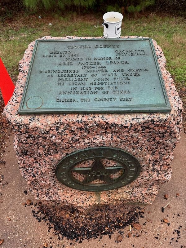
On State Highway 155 0.1 miles south of Farm to Market Road 1002, on the right when traveling north.
Created April 27, 1846
Organized July 13, 1846
Named in honor of Abel Packer Upshur
1790-1844
Distinguished debater and orator.
As Secretary of State under
President John Tyler
he began negotiations
in 1843 for the
annexation . . . — — Map (db m266812) HM
On Magrill Street at N 5th Street on Magrill Street.
Georgia native O.H. Methvin came to Texas about 1848 with his wife Margaret and his father, Richard R. Methvin. They settled on land in Upshur County which would later become a part of Gregg County. In 1870 Methvin gave 100 acres of land to the . . . — — Map (db m290334) HM
On North Avenue north of Church Street, on the left when traveling north.
The Texas Legislature created Camp County from the northern part of Upshur County in 1874, and voters chose Pittsburg as their county seat. The county built its first courthouse in 1881. As Pittsburg grew, the two-story brick edifice became too . . . — — Map (db m139364) HM
On North High Street at Waskom St on North High Street.
For years major oil companies had contended there is "No oil in East Texas." They were proven wrong when Columbus Dad Joiner's third oil well hit the Woodbine Sand on October 3, 1930. Joiner's Daisy Bradford #3 roared in at a depth of 3,592 feet and . . . — — Map (db m268987) HM
On Texas Route 155 east of Verbena Road, on the right when traveling west.
Ferry point near this site, on Big Cypress. Important town of 1850's, with an academy, 2 dry goods stores, 2 groceries, drug store, 3 doctors, Methodist and Presbyterian churches, a hotel and Masonic Lodge.
During Civil War, lived up to its . . . — — Map (db m119445) HM
On Farm to Market Road 1585 2.5 miles west of State Highway 214, on the left when traveling west.
Once encompassing more than 33,000 acres, the area known locally as the Old Surratt Territory is representative of the late-19th century settlement and ranching history of the vast grasslands of the Texas Panhandle. Marshall Surratt (1849-1927), . . . — — Map (db m167632) HM
Near East Methvin Street at North Green Street when traveling north.
In January 1873, Upshur County Representative B.W. Brown (a Methodist lay preacher) introduced a bill in the Texas Legislature to make Longview the seat of a new county to be composed of portions of existing Upshur, Rusk and Harrison counties. The . . . — — Map (db m89156) HM
On East Marshall Street east of Simpson Street, on the left when traveling east.
Oldest continuous business in this county. Founded as weekly, "Upshur County Democrat," Jan. 1, 1877. Early owners included W. C. Paul, the Rev. S. R. Chadick, and J. P. Hart, who named it "Texas Mirror" in 1882; "Gilmer Mirror," 1895. Owned since . . . — — Map (db m139419) HM
On Farm to Market Road 2454 at Mule Deer Road, on the left when traveling north on Highway 2454.
One of three pioneer roads that crossed Upshur County and aided in development of Texas. Was heavily used by freighters and settlers heading west ward and by those exporting cotton, hides and produce to the inland Port at Jefferson. Was crossed at . . . — — Map (db m161013) HM
On West Tyler Street (Texas Route 154) at Davis Street, on the right when traveling west on West Tyler Street.
Upshur County, C. S. A.
Civil War supply and activity center. Men and boys served in the Confederate army on many battlefronts and in state troops protecting Texas from invasion. 3 military training camps were set up. Vital needs for . . . — — Map (db m299767) HM
On East Magrill Street at North Fourth Street, on the right when traveling west on East Magrill Street.
In 1855 Alabama-born John Tyson Smith moved with his parents to Upshur County Texas. A Confederate veteran, he settled in Longview about 1872. He served as City Tax Assessor and was Justice of the Peace for two terms. He was elected to five terms . . . — — Map (db m290333) HM
On Simpson Street at East Jefferson Street, on the right when traveling north on Simpson Street.
Designed by architect James A. Wetmore, this building was constructed by A. C. Stamford of Alabama, who employed workers from Alabama and from Upshur County. Construction began in June 1925 and was completed early the following year. This structure . . . — — Map (db m139418) HM
On West Cass Street near Davis Street, on the right when traveling west.
In 1933, the Ragland family opened the first full-time hospital in Upshur County. Thomas Scott Ragland, M.D. (1872 – 1936) came to Texas in 1895; he settled in Gilmer in 1902 with his wife, Mamie Helen (Denson). In addition to serving as the . . . — — Map (db m139398) HM
On North Main Street (U.S. 271) north of Allison Street, on the left when traveling north.
Built 1890 on site purchased 1884 by William Emmett and Mary R. Foshee. He was a native of Alabama and she was a member of the pioneer Shepperd family of Upshur County. Eight children were born to this couple.
Lumber for house was sawed at . . . — — Map (db m139096) HM
Near Bolivar Street at East Houston Street, on the left when traveling north.
In memory of Peter Whetstone and Dicey Whetstone, pioneer settlers in Harrison County. Donors in 1843 of the site of the City of Marshall, a part of the Peter Whetstone headright granted in 1838 by the Republic of Texas. — — Map (db m258030) HM
Near Camden Avenue north of Walktrail Lane, on the left when traveling north.
Family: Anacardiaceae (Cashew Family)
Distribution: Our eastern poison ivy grows throughout eastern North America, up through Quebec and Ontario and west into Texas and Oklahoma. It is found in most of West Virginia's counties and can be . . . — — Map (db m272410) HM
Thin black lines indicate changes in relevance. Between each pair of lines entries are ordered geographically but all have the same relevance.
* Inflectional forms of words are their plurals, singulars, and possessives as well as gramatical tenses and similar variations.