
24 entries match your criteria.
Entries Containing All of the Phrases «charleston county» AND «south carolina»
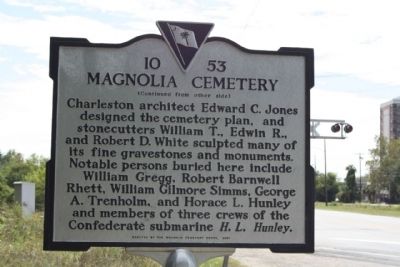
By Mike Stroud, October 4, 2009
Magnolia Cemetery Marker, reverse side text
RANKED BY RELEVANCE
1 ► South Carolina, Charleston County, Charleston, Nomo — 10-53 — Magnolia Cemetery —  |
| On Meeting Street Road (U.S. 52) near Cunnington Avenue, on the right when traveling north. | |||
| 2 ► South Carolina, Charleston County, Mount Pleasant — Charles Pinckney - Statesman — Snee Farm — Charles Pinckney National Historic Site — |
| Near Long Point Road 0.6 miles west of U.S. 17 when traveling south. | |||
| 3 ► South Carolina, Colleton County, Green Pond — 15-13 — Temple of Sport — |
| On Ace Basin Pkwy (U.S. 17) 0.1 miles south of Green Pond Highway (State Highway 303), on the left when traveling north. | |||
| 4 ► South Carolina, Charleston County, Charleston, South of Broad — U.S. Post Office and Courthouse — |
| On Broad Street at Meeting Street, on the right when traveling east on Broad Street. | |||
| 5 ► South Carolina, Charleston County, Sullivan's Island — This is Sullivan's Island — |
| On Poe Ave. | |||
| 6 ► South Carolina, Abbeville County, Abbeville — First Burial in Long Cane Cemetery — |
| Near Greenville Street (State Highway 20). | |||
| 7 ► South Carolina, Abbeville County, Abbeville — 1-16 — Long Cane Cemetery — |
| On Greenville Street (State Highway 20) near Beltline Road (County Road S-1-35). | |||
| 8 ► South Carolina, Charleston County, Charleston, South of Broad — Ingraham-Forrest House — 10 King Street — circa 1800 — |
| On King Street just south of Lamboll Street, on the left when traveling south. | |||
| 9 ► South Carolina, Charleston County, Mount Pleasant — "Storm of the Century" — |
| On Royall Avenue close to Bank Street. | |||
| 10 ► South Carolina, Charleston County, Charleston, Harleston Village — Quaker Cemetery — |
| On King Street near Queen Street. | |||
| 11 ► South Carolina, Charleston County, Sullivan's Island — African American Cemetery — |
| On Station 22 1/2 Street (State Highway 703) north of Myrtle Avenue, on the left when traveling south. | |||
| 12 ► South Carolina, Greenville County, Greenville — Joel Roberts Poinsett — 1759 - 1851 — |
| On South Main Street. | |||
| 13 ► South Carolina, Greenville County, Greenville — 23-11 — Joel Roberts Poinsett — 1779-1851 — |
| On South Main Street at West Court Street on South Main Street. | |||
| 14 ► South Carolina, Charleston County, Charleston, French Quarter — The Nicholas Trott House — 83 Cumberland Street — |
| On Cumberland Street, on the left when traveling west. | |||
| 15 ► South Carolina, Greenville County, Greenville — In Memory of 81st Wildcat Division / Camp Sevier — |
| On North Main Street. | |||
| 16 ► South Carolina, Greenville County, Greenville — Mrs. James Williams — |
| On North Main Street at Elford Street on North Main Street. | |||
| 17 ► South Carolina, Greenville County, Taylors — 23-2 — Camp Sevier — |
| On Wade Hampton Boulevard (U.S. 29) at Artillery Road, on the left when traveling north on Wade Hampton Boulevard. | |||
| 18 ► South Carolina, Charleston County, Sullivan's Island — Grave of General William Moultrie — |
| On Middle Street, on the right when traveling west. | |||
| 19 ► South Carolina, Charleston County, Sullivan's Island — Major General William Moultrie — 1730 - 1805 — |
| Near Middle Street west of Station 13 Street, on the right when traveling west. | |||
| 20 ► South Carolina, Oconee County, Walhalla — South Carolina National Heritage Corridor — |
| Near Stumphouse Tunnel Road near State Highway 28, on the right when traveling west. | |||
| 21 ► South Carolina, Charleston County, Mount Pleasant — Harry M. Hallman, Jr. — A Lifetime of Public Service — |
| On Harry M. Hallman, Jr. Blvd, on the right when traveling south. | |||
| 22 ► South Carolina, Orangeburg County, Holly Hill — Holly Hill — |
| On State Street (U.S. 176) at Depot Street, on the left when traveling east on State Street. | |||
| 23 ► South Carolina, Charleston County, Charleston, French Quarter — George Washington Statue — |
| Near Meeting Street near Broad Street, on the right. | |||
| 24 ► South Carolina, Oconee County, Newry — The Church Bell — |
| On Broadway Street (State Highway 37-203) at Palmetto Avenue, on the left when traveling east on Broadway Street. | |||
Thin black lines indicate changes in relevance. Between each pair of lines entries are ordered geographically but all have the same relevance.
* Inflectional forms of words are their plurals, singulars, and possessives as well as gramatical tenses and similar variations.
Nov. 20, 2026