109 entries match your criteria. Entries 101 through 109 are listed.⊲ Previous 100
Historical Markers and War Memorials
in Elko Country
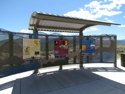
By Duane Hall, May 30, 2013
Schellbourne: Gateway to the Goshute Nation Marker
101 ► Nevada, White Pine County, McGill — Schellbourne: Gateway to the Goshute Nation —  |
| Before Schellbourne: Before the Lincoln Highway, before the Pony Express, and before wagon trains rolled across the plains, the Kusiutta people (the Goshute people) lived here. This desert home has made survival difficult, but the extreme . . . — — Map (db m67832) HM | |||
| 102 ► Nevada, White Pine County, McGill — Speedy Riders — |
| The first teams of Pony Express riders amazed the nation by accomplishing their east and west bound deliveries within the projected 10 day schedule. The speed of the riders even had a role in swaying a divided California to stay with the union . . . — — Map (db m67128) HM | |||
| 103 ► Nevada, White Pine County, McGill — Strength and Endurance — |
| Descriptions of the variety and number of horses used by the Pony Express became distorted during the course of its history since November 1861. In general, the type of horse used for carrying the rider and mail depended greatly on the region. The . . . — — Map (db m67127) HM | |||
| 104 ► Nevada, White Pine County, McGill — The Crowds Cheered On ... — |
| In 1845, it took six months to get a message from the East Coast of the United States to California. By the late 1850s, a half million people had migrated west and were demanding up-to-date news from home. Something had to be done to deliver mail . . . — — Map (db m67129) HM | |||
| 105 ► Nevada, White Pine County, McGill — The Lincoln Highway — A Vision that Spanned America — |
| The Visionary: Carl Fisher was a dreamer with an entrepreneurial spirit. After amassing a large fortune and building a reputation in the auto-parts industry, Fisher began to dream of building a paved hard-surface, coast-to-coast highway. He . . . — — Map (db m67131) HM | |||
| 106 ► Nevada, White Pine County, McGill — The Pony Express — A Journey Across the American West — |
| Mail From Coast to Coast: During the mid-1800s, American settlers were on the move, relocating from crowded Eastern cities to the untamed wilderness of the West. Many made their way to California. With the surge of settlers, California began . . . — — Map (db m67130) HM | |||
| 107 ► Nevada, White Pine County, Ruth — 9 — Copper Country — |
| 1864–1964. The famed open-pit copper mines of Eastern Nevada including the Liberty Pit, largest in the state, are located two miles south of this point. Through the first half of the 20th century, this area produced nearly a billion . . . — — Map (db m69494) HM | |||
| 108 ► Nevada, White Pine County, Schellbourne — CON-5 — Central Overland Trail - Rock Springs — |
| Passed Antelope to Rock Springs, where coming out of a rock is a stream of the coldest, purest water. Some one has driven a spigot into the crevice, making a spout…the most desirable camp of the journey." - William Carter Moss, Aug 2, 1861 — — Map (db m249470) HM | |||
| 109 ► Nevada, White Pine County, Shanty Town — Fort Ruby — 1862 - 1869 — |
| Colonel P. Edward Connor was ordered to build and command this post in 1862. The fort was built midway between Salt Lake City, Utah and Carson City, Nevada to protect the Overland Mail Route (Pony Express) and emigrant travelers from Indian raiders. . . . — — Map (db m74710) HM | |||
109 entries matched your criteria. Entries 101 through 109 are listed above. ⊲ Previous 100