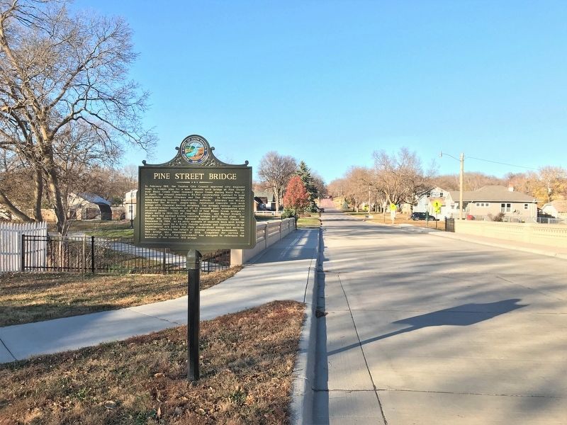
On Pine Street north of East 6th Street, on the left when traveling north.
In February 1912, the Yankton City Council approved city engineer Hugh C. Liebe's plan for a new concrete arch bridge at Pine Street over Rhine Creek (later renamed Marne Creek during World War I). In April, the council awarded a $3,700 construction . . . — — Map (db m211680) HM
Near Levee Street 0.1 miles south of Pearl Street, on the right when traveling east.
The Missouri flows free for 59 miles below Gavins Point Dam and for 39 miles below Fort Randall Dam. These sections of the national recreational river provide glimpses of the once undammed, unchannelized river that played a major role in America's . . . — — Map (db m189403) HM
The Missouri, the continent's longest river, figures prominently in the unfolding of America's saga. Flowing nearby in its 2,341 - mile course from the Rocky Mountains to the Mississippi, the Big Muddy is not only loaded with sediment but steeped in . . . — — Map (db m232821) HM
On Walnut Street at West 3rd Street, on the right when traveling north on Walnut Street.
This corner of Walnut and 3rd Streets has been the focal point of many historical events in Yankton. Among the most significant were visits by William Jennings Bryan, President William McKinley, and President Theodore Roosevelt.
William . . . — — Map (db m211682) HM
In 1804-1806, Captains Meriwether Lewis and William Clark led
the Corps of Discovery on an epic journey. Charged by President
Thomas Jefferson to find a water route to the Pacific Ocean through
the newly acquired Louisiana territory, they mapped . . . — — Map (db m191294) HM
On West 3rd Street at Broadway Avenue (U.S. 81), on the right when traveling east on West 3rd Street.
This boulder marks the site of
The Yankton Stockade
in which the people of the
surrounding country took refuge
during the Sioux Outbreak of 1862 — — Map (db m178447) HM
On Capital Street 0.1 miles south of East 4th Street, on the right when traveling south.
At Deadwood on August 2, 1876, Jack McCall shot "Wild Bill" Hickok in the back of his head. When a vigilante court tried him, he claimed Bill had killed his brother and the vigilantes let him go. Later, due to his boasting, at Laramie City, US . . . — — Map (db m177712) HM
On Riverside Drive west of Douglas Avenue, on the left when traveling west.
Scorpion's first patrol was a hunting and mining mission near Honshu in April 1943. Scorpion fiercely assaulted enemy vessels in a series of submerged torpedo attacks and surface gun battles. She sank two freighters, four sampans and two patrol . . . — — Map (db m211681) HM WM
On Linn Street at Third Street, on the right when traveling south on Linn Street.
Indian war of Outbreak, August 1862 threatened to spread into Dakota and a “strong point” for all settlers near Yankton was built in September under Capt. F. M. Ziebach. The west wall, of posts with boards on either side and earth packed between 450 . . . — — Map (db m177907) HM
On West Riverside Drive 0.3 miles south of West 4th Street (State Route 50), on the right when traveling east.
William McMaster (1877-1968) was a progressive Republican banker and politician who fought for farmers facing hard times. He was also involved in building this Meridian Bridge.
Orphaned at 17 in Iowa, he graduated from Beloit College and came . . . — — Map (db m177897) HM
On East 10th Street 0.3 miles east of Broadway Avenue (U.S. 81), on the right when traveling west.
Joseph Ward, a graduate of Brown University and Andover Seminary came to Yankton Academy but it was taken over by the school board and became Yankton High School, the first secondary schools in Dakota.
In May 1881, Yankton College was . . . — — Map (db m177858) HM
Near Douglas Avenue east of West 20th Street, on the right when traveling north.
In memory of
the Yankton County veterans of World War II
who gave the supreme sacrifice for freedom
Glenn H. Allen ·
Donald L. Barger ·
William J. Bauer ·
Chester M. Beaver ·
William F. Blau ·
Thomas B. Brady ·
William M. Brewer . . . — — Map (db m211684) WM
Smoke-belching steamboats plied the riverway here
from 1832 to 1900. Servicing forts, Indian agencies, and
frontier villages, Sioux City and other ports dominated
trade on the Upper Missouri because of their proximity
to railroads. With its new . . . — — Map (db m191177) HM
On Park Drive near Levee Street, on the left when traveling east.
Thanks to Abraham Lincoln, Yankton became the first
capital of the huge Dakota Territory. Formed in March
1861 just before Lincoln's presidency, the territory
extended west of Minnesota to the Rockies and north
of Nebraska to Canada. Lincoln . . . — — Map (db m191176) HM
115 entries matched your criteria. Entries 101 through 115 are listed above. ⊲ Previous 100