THE HISTORICAL
MARKER DATABASE
“Bite-Size Bits of Local, National, and Global History”


25 entries match your criteria.  


Related Historical Markers

A list of the tablets placed throughout the city of Chattanooga, in the mid-1890s, that identify historical points in connection with the occupancy of Chattanooga by Federal and Confederate troops.
 
By Duane and Tracy Marsteller, October 16, 2021
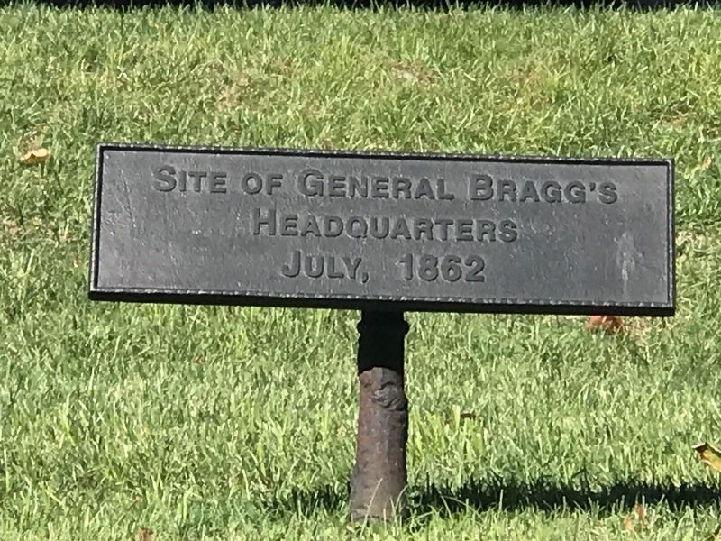
Site of General Bragg's Headquarters Marker
SHOWN IN SOURCE-SPECIFIED ORDER
1 ► Tennessee, Hamilton County, Chattanooga, City Center — MT-27 — Site of General Bragg's Headquarters —
On East 5th Street east of Georgia Avenue, on the left when traveling east.
Site of General Bragg's Headquarters July, 1862 — — Map (db m68841) HM
2 ► Tennessee, Hamilton County, Chattanooga, City Center — MT-55 — Headquarters of Brigadier General George D. Wagner —
On East 5th Street east of Georgia Avenue, on the left when traveling east.
Headquarters of Brig. Gen. George D. Wagner, U.S.V., Upon First Occupation of Chattanooga. — — Map (db m68842) HM
3 ► Tennessee, Hamilton County, Chattanooga, City Center — MT-52 — Point in the Line of Fort Sherman —
On Lookout Street at East 5th Street, on the right when traveling north on Lookout Street.
Point in the line of Fort Sherman, The Chief Work of the Inner Line, Which comprised the entire line From Battery Bushnell to Signal Hill. — — Map (db m76289) HM
4 ► Tennessee, Hamilton County, Chattanooga, Martin Luther King — MT-59 — S.W. Angle of Fort Wood —
On Vine Street east of Palmetto Street, on the left when traveling east.
S.W. Angle of Fort Wood (Creighton), East Salient of Outer Line. — — Map (db m58773) HM
5 ► Tennessee, Hamilton County, Chattanooga, Southside Historic District — MT-62C — A point in the 2D Line of Works —
On Chestnut Street south of West 13th Street, on the right when traveling north.
A Point in the 2d Line of Works, Connecting Fort Jones with Fort Lytle.

— — Map (db m68843) HM
6 ► Tennessee, Hamilton County, Chattanooga, Martin Luther King — MT-48 — A Point in the Line of Works —
On McCallie Avenue west of Douglas Street, on the left when traveling west.
A Point in the Line of Works, Connecting Fort Sherman with Battery Erwin. — — Map (db m76441) HM
7 ► Tennessee, Hamilton County, Chattanooga, Martin Luther King — MT-50 — Point in the Line of Fort Sherman —
On Lindsey Street at East 5th Street, on the left when traveling south on Lindsey Street.
Point in the Line of Fort Sherman, The Chief Work of the Inner Line, Which comprised the entire line from Battery Bushnell to Signal Hill. — — Map (db m76442) HM
8 ► Tennessee, Hamilton County, Chattanooga, City Center — A Point in the 2d Line of Works —
On Lindsey Street north of East 11th Street, on the right when traveling south.
A point in the 2d Line of Works, Connecting Battery Erwin with Fort Jones. — — Map (db m76443) HM
Paid Advertisement
9 ► Tennessee, Hamilton County, Chattanooga, Bluff View — MT-54 — Site of Battery Smartt —
On Bluff View north of East 2nd Street, on the right when traveling west.
Confederate Work, General Cheatham's Division — — Map (db m76445) HM
10 ► Tennessee, Hamilton County, Chattanooga, City Center — MT-62D — Site of Crutchfield House —
Near Broad Street north of West Martin Luther King Boulevard, on the right when traveling south.
Site of Crutchfield House, Used as Hospital, September 20, 1863. Accommodated 500 wounded that day. — — Map (db m87284) HM
11 ► Tennessee, Hamilton County, Chattanooga, Southside Historic District — MT-62B — A point in the 2D Line of Works
On Carter Street near West 14th Street, on the left when traveling north. Reported missing.
A Point in the 2d Line of Works, Connecting Fort Jones with Fort Lytle.

— — Map (db m122339) HM
12 ► Tennessee, Hamilton County, Chattanooga, City Center — MT-61B — Site of Headquarters — Lieutenant General Daniel H. Hill, C.S.A. — Major General John M. Palmer, U.S.V.
On West 6th Street west of Pine Street, on the left when traveling west. Reported missing.
Site of Headquarters Lieutenant General Daniel H. Hill, C.S.A. Commanding Corps Major General John M. Palmer, U.S.V. Commanding 14 Corps Army of the Cumberland — — Map (db m122358) HM
13 ► Tennessee, Hamilton County, Chattanooga, Southside Historic District — MT-60B — East Angle of Fort Phelps
On Read Street at East 17th Street, on the right when traveling north on Read Street. Reported missing.
East Angle of Fort Phelps (Negley) Begun by Confederates as Fort Cheatham — — Map (db m122392) HM
14 ► Tennessee, Hamilton County, Chattanooga, Southside Historic District — MT-60 — Center of Fort Phelps
On Mitchell Street south of East 16th Street, on the left when traveling south. Reported missing.
Center of Fort Phelps (Negley) Southern Salient of Outer Line Begun by Confederates as Fort Cheatham 4 - 20 Pounders 8 - 10 Pounders 6 Napoleons — — Map (db m122424) HM
15 ► Tennessee, Hamilton County, Chattanooga, Southside Historic District — MT-42 — Southeast Angle of Fort Phelps
On Read Street south of East 17th Street, on the left when traveling south. Reported missing.
Southeast Angle of Fort Phelps (Negley) Begun By Confederates As Fort Cheatham — — Map (db m122823) HM
16 ► Tennessee, Hamilton County, Chattanooga, Martin Luther King — MT-57 — Site of Headquarters
On Vine Street east of Houston Street, on the right when traveling east. Reported missing.
Site of Headquarters Brigadier General Thomas J. Wood, U.S.V. Commanding 3rd and 4th Corps — — Map (db m122506) HM
17 ► Tennessee, Hamilton County, Chattanooga, Martin Luther King — MT-56 — Site of Headquarters
On Douglas Street south of East 5th Street, on the right when traveling south. Reported missing.
Site of Headquarters Major General Joseph Wheeler, C.S.A. Commanding Cavalry Corps — — Map (db m122519) HM
Paid Advertisement
18 ► Tennessee, Hamilton County, Chattanooga — MT-46 — Point in the Line of Fort Sherman
On Battery Place west of Mabel Street, on the left when traveling west. Reported missing.
Point in the line of Fort Sherman, the Chief Work of the Inner Line, which comprised the entire line from Battery Bushnell to Signal Hill. — — Map (db m122523) HM
19 ► Tennessee, Hamilton County, Chattanooga, City Center — MT-49 — Point in the Line of Fort Sherman
On Georgia Avenue at East 5th Street, on the right when traveling north on Georgia Avenue. Reported missing.
Point in the line of Fort Sherman, The Chief Work of the Inner Line, Which comprised the entire line From Battery Bushnell to Signal Hill. — — Map (db m122526) HM
20 ► Tennessee, Hamilton County, Chattanooga, Martin Luther King — MT-40 — Site of Lunette O'Meara
On East 5th Street at Lindsay Street, on the right when traveling east on East 5th Street. Reported missing.
Site Of Lunette O'Meara Center of Line Of Fort Sherman 2 Siege - 6 Field Guns — — Map (db m122551) HM
21 ► Tennessee, Hamilton County, Chattanooga, City Center — MT-28 — Headquarters of Brigadier General John M. Brannan, U.S.V.
On Walnut Street south of East 3rd Street, on the left when traveling south. Reported missing.
Headquarters Brigadier General John M. Brannan, U.S.V. Chief of Artillery Department of the Cumberland — — Map (db m122553) HM
22 ► Tennessee, Hamilton County, Chattanooga, Martin Luther King — MT-39 — Site of Camp
On Houston Street north of McCallie Avenue, on the right when traveling north. Reported missing.
Site of Camp 10th Ohio Volunteers, Colonel J. W. Burke Where First Shell From Lookout Exploded — — Map (db m122554) HM
23 ► Tennessee, Hamilton County, Chattanooga, Martin Luther King — MT-33 — A point in the 2D Line of Works
On East 10th Street east of Lindsay Street, on the left when traveling east. Reported missing.
A point in the 2d Line of Works, Connecting Battery Erwin with Fort Jones. — — Map (db m122556) HM
24 ► Tennessee, Hamilton County, Chattanooga, Martin Luther King — MT-34 — A point in the 2D Line of Works
On East 8th Street east of Houston Street, on the right when traveling east. Reported missing.
A point in the 2d Line of Works, Connecting Battery Erwin with Fort Jones. — — Map (db m122559) HM
25 ► Tennessee, Hamilton County, Chattanooga, Riverfront — MT-36 — Headquarters of Major General U. S. Grant, U.S.A.
On East 1st Street east of Market Street (Tennessee Route 8), on the right when traveling east. Reported missing.
Headquarters Major General U. S. Grant, U. S. A. Commanding Military Division Of the Mississippi And of His Successor Major General W. T. Sherman, U. S. V. — — Map (db m122565) HM
 
 
CeraNet Cloud Computing sponsors the Historical Marker Database.
This website earns income from purchases you make after using our links to Amazon.com. We appreciate your support.
Paid Advertisement
Oct. 10, 2026
