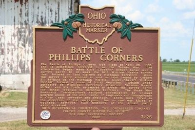
On Ohio Route 109 at Route 120, on the left when traveling north on Ohio Route 109.
The Ohio Michigan Boundary War. The Northwest Ordinance of 1787 defined the boundary of the northern and southern tier of states to be carved out of the Northwest Territory, as a line drawn east from the southernmost tip of Lake Michigan . . . — — Map (db m21009) HM
On South Dixie Highway 0.1 miles north of East Temperance Road, on the right when traveling south. Reported missing.
Michigan troops made heir headquarters here during the bloodless Toledo "war" in 1835.
Intense rivalry between the settlers of the two states fanned a controversy near flame. Original U. S. surveys had put in Monroe County the mouth of the . . . — — Map (db m268205) HM
On East First Street at Washington Street on East First Street.
Monroe County was established in July, 1817, as one of the first steps in the organization of Michigan Territory after the War of 1812.
Then the old settlement of Frenchtown which centered upon this square took the name of Monroe and became the . . . — — Map (db m27634) HM
On Edgewater Drive at Lost Peninsula Marina Drive, on the right when traveling north on Edgewater Drive.
[Front of Marker]
STATE LINE
Surveyed By
S. S. Gannet
Geographer
United States
Geological Survey
1915
[Ohio Side of Marker]
OHIO
Frank B. Willis
Governor
- - - - -
Erected by Authority of
The . . . — — Map (db m197401) HM
On Jackson Road at North Huron Street, in the median on Jackson Road.
[Front Side of Marker, Facing South]:"Toledo"
After consolidation of the villages of Fort Lawrence and Vistula, the City of Toledo was incorporated in 1837. Originally named "Toledo" in 1833, the site became part of Ohio when the . . . — — Map (db m27063) HM
On Adams Street at North Erie Street, on the right when traveling west on Adams Street. Reported missing.
Lucas County was named for Governor Robert Lucas who championed Ohio's cause in the "Toledo War," a boundary dispute arising when both Ohio and the Michigan Territory claimed this area. The Ohio legislature created Lucas County on June 20, 1835. . . . — — Map (db m245673) HM
On Erie Road at South Dixie Highway (Michigan Route 125), on the right when traveling east on Erie Road.
Michigan troops made heir headquarters here during the bloodless Toledo "war" in 1835.
Intense rivalry between the settlers of the two states fanned a controversy near flame. Original U. S. surveys had put in Monroe County the mouth of the . . . — — Map (db m277283) HM