In early June 1863, the Confederate Army of Northern Virginia led by General Robert E. Lee began to leave its camps in Virginia and march northward to Pennsylvania. Lee hoped that a victory on Northern soil might break the will of the Northern . . . — — Map (db m5020) HM
As the initial attack by the 13th Virginia and 2nd North Carolina Cavalry Regiments gained momentum, they charged along Frederick Street and through the Forney fields which were located on the land in front of you. On your left, the retreating Union . . . — — Map (db m8652) HM
"We had better go down stairs; we are in danger here," Mrs. Henry Winebrenner said to her daughter, Martha, after seeing the flash and hearing the roar from Confederate artillery. - The Evening Herald, January 25, . . . — — Map (db m8653) HM
At approximately 8:00 a.m. the head of Kilpatrick's Union Cavalry Division halted on Frederick Street. When Reverend William K. Zieber, pastor of Emmanuel Reformed Church learned about the hungry cavalrymen, he encouraged the crowd of townspeople to . . . — — Map (db m104722) HM
A lull in the fighting after the first charge of the Battle of Hanover prompted several Hanover physicians to begin caring for the wounded on the streets and sidewalks. Among them were Drs. George Hinkle, Henry Eckert, Horace Alleman, Jacob Smith, . . . — — Map (db m201486) HM
A Glimpse of Hanover's Past The chaotic fighting at the Center Square quickly spilled over onto several side streets, alleys, and fields. At the first sign of trouble, Major John Hammond led an organized withdrawal of the 5th New York Cavalry . . . — — Map (db m8658) HM
"After they had passed out Frederick Street the doctor and I picked up three or four dead soldiers, lying in the street between Centre Square and the Reformed Church, and carried them to the side-walks" -Rev. Wm. K. Zeilber, pastor Emmanuel . . . — — Map (db m10394) HM
Hanover photographer Peter S. Weaver, who operated a studio on Baltimore Street, recorded this view dated February 6, 1864. The man holding the book in the photo is Samuel Weaver, Peter's father. Samuel supervised the operation in which the . . . — — Map (db m201488) HM
Elements from the 2nd North Carolina Cavalry Regiment charged past this point in pursuit of disorganized remnants of the 18th Pennsylvania Cavalry Regiment which was retreating toward the railroad tracks. The Union Cavalry appeared to have abandoned . . . — — Map (db m8647) HM
The original Moul Townhouse stood to your right. It was the mirror image of the 215 Broadway townhouse behind you. By 1915, the Moul Family replaced it with the Neoclassical Revival style brick home designed by Dempwolf Architects of York, which you . . . — — Map (db m22416) HM
From Hanover's Center Square, major roads radiate to York, Baltimore, Frederick and Carlisle. For the second time that day the Center Square would become the scene of brutal combat.
A few blocks to the north, nearly 400 mounted cavalrymen from . . . — — Map (db m201491) HM
June 30, 1863
between Brig. Gen. Judson Kilpatrick's
3rd Cavalry Division Army of the Potomac
and
Major Gen. J.E.B. Stuart's Cavalry Division
Army of Northern Virginia — — Map (db m4997) HM
Headquarters Army of the Potomac moved from Middleburg to Taneytown. First Corps marched from Emmitsburg to Marsh Run, third Corps from Taneytown to Bridgeport. Fifth Corps from Liberty via Johnsville Union Bridge and Union to Union Mills. Sixth . . . — — Map (db m197224) HM
First Corps marched from Marsh Run, Eleventh Corps from Emmitsburg to Gettysburg. Second Corps from Uniontown via Taneytown to near Gettysburg. Third Corps from Bridgeport via Emmitsburg to the field of Gettysburg. Fifth Corps from Union Mills via . . . — — Map (db m197219) HM
On June 30, 1863, Gen. Kilpatrick, commanding the Third Division of the Union Cavalry, took headquarters in this building after part of his forces had been attacked by Confederate Cavalry SE of town. — — Map (db m5005) HM
On the morning of June 30, 1863, Confederate Cavalry under General Stuart attacked the rear of Union Cavalry S E of here and, for a while, had possession of the town. The attack repulsed, Stuart withdrew in the evening. — — Map (db m4995) HM
1839 ---- 1876
Killed in Battle of Little Big Horn River, Montana, in Sioux Indian War.
Was Brig. Gen. Commander of 1st, 5th, 6th, 7th, Michigan Cavalry Regiments and Pennington's Battery at the Battle of Hanover June 30, 1863.
In the . . . — — Map (db m77183) HM
"Our town on Tuesday for the first time saw and felt all the incidents, scenes and horrors of actual war." The Hanover Spectator, founded by Senary Leader in 1844, was owned by his widow, Maria, at the time of the Civil War. It was published . . . — — Map (db m8650) HM
Fragments of several Union and Confederate cavalry regiments continued to fight a running battle as they galloped on horseback along Frederick Street. Other Confederate bands had retreated down the intersecting alleys and streets. This action . . . — — Map (db m5026) HM
By the time the counter attack on the 5th New York Cavalry Regiment had reached this area, the center of Hanover was once again under Union control. The New Yorkers continued along Frederick Street but were soon halted by gunfire from Confederate . . . — — Map (db m201492) HM
The ground occupied by the Confederate cavalry during the Battle of Hanover was the rich, rolling farmland found in much of southern Pennsylvania. On the eastern side of the Westminster Road there was a field of timothy, a grass widely grown for . . . — — Map (db m149208) HM
This painting by Civil war artist Dale Gallon is one of four paintings featuring Civil War weapons.
George Armstrong Custer had been promoted from Captain to Brigadier General on June 28, 1863, and been given command of the Michigan Brigade, . . . — — Map (db m5021) HM
Possibly less than twenty minutes after the first shots, Hanover was once again in Union control. Although the intense fighting along Frederick Street had subsided, the conflict was far from finished. A standoff ensued as the Confederates . . . — — Map (db m197220) HM
"Every desired comfort is furnished in great abundance, and every luxury, with which this country abounds in great profusion, is supplied by sympathetic people, and administered to the suffering wounded by devoted women. A heartier response to . . . — — Map (db m22722) HM
One-half block east of here, on Nov. 18, 1863, Abraham Lincoln spoke briefly to townspeople from his special train. The President was traveling to Gettysburg for the dedication of the National Cemetery. — — Map (db m14880) HM
Men of Gen. Early's Confederate army, detached by Gen. Gordon to destroy a bridge at Hanover Junction, passed through Hanover by this route, June 27, 1863. This work done, the detachment rejoined Gen. Gordon west of York. — — Map (db m173794) HM
During the June 1863 invasion of Pennsylvania, Confederate Lieutenant General James Longstreet explained to English observer Lieutenant Colonel Arthur Freemantle that the army planned to live off Northern land - and its citizens. But they would not . . . — — Map (db m22752) HM
George Armstrong Custer was appointed brigadier general on June 29, 1863, and assigned as commander of the Michigan brigade which he led as the Union cavalry entered Hanover on the morning of June 30, 1863. Pastor Zieber stated, "During the charge . . . — — Map (db m197218) HM
Mother Loses Two Sons to War - Within the span of one year, Elizabeth Hoffacker of West Manheim Township received the news of her two sons' deaths in combat during the Civil War. John, 24 years old, was promoted to corporal after being in the army . . . — — Map (db m188532) HM
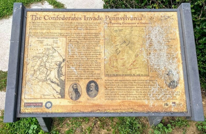
The engagement fought in Hanover may have had an effect on the outcome of the Battle of Gettysburg. As General Robert E. Lee moved north toward Pennsylvania in June 1863, Major General J.E.B. Stuart’s cavalry began to ride around the Union Army and . . . — — Map (db m22694) HM
On June 30, 1863, the quiet little town of Hanover suddenly exploded in gunfire and bloodshed. The Battle of Hanover, fought between Confederate Cavalry led by Major General J.E.B. Stuart and Brigadier General Judson Kilpatrick's Union Cavalry, . . . — — Map (db m22748) HM