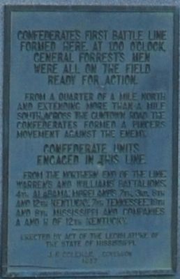
at 1:00 o'clock. General Forrest's men were all on the field ready for action. From a quarter of a mile north and extending more than a mile south across the Guntown Road the Confederates formed a pincers movement against the enemy. Confederate . . . — — Map (db m62106) HM
From 500 hundred yards north and extending more than a mile south, across the Guntown Road, this Line, behind rail fences and dense scrub-oak thickets fought stubbornly as the Confederates pushed on to the Crossroads. Hand to hand fighting along . . . — — Map (db m62108) HM
Pushing the Union forces back, General Forrest slowly closed his pincers movement, forcing General Sturgis nearer the Crossroads. This line was anchored on the Blackland Road 400 yards northwest. The southern end across the Guntown Road. . . . — — Map (db m62110) HM
Maj. Gen. Nathan Bedford Forrest "owned" northern Mississippi and southwestern Tennessee in mid-1864, but that was not where the war was being won or lost. Port Hudson, Louisiana, and Vicksburg, Mississippi, had fallen in July 1863, giving the Union . . . — — Map (db m62170) HM
Brig. Gen. Benjamin Grierson's Federal cavalry (3,300 troops) left Stubbs plantation (nine miles northwest of Brice's Cross Roads) at daybreak on June 10, 1864. By 10:00 a.m. the cavalry had reached Brice's Cross Roads and advance units had . . . — — Map (db m62172) HM
By 10:00 a.m. on June 10, 1864, Col. George Waring's Federal cavalry had reached the Cross Roads. The troops deployed on either side of the Baldwyn Road, in the woods at the western edge of a cleared field, one-half mile east of the Cross Roads. . . . — — Map (db m62173) HM
To Hold
The Crossroads
Placing the 93rd Illinois,
8th Illinois and 114th
Illinois Infantry here and
immediately behind, he
placed his artillery
consisting of Battery B
of 2nd Illinois; 7th Wisconsin
Battery; 14th Indiana . . . — — Map (db m5738) HM
When General Sherman advanced on Atlanta, General Forrest sought to destroy the Union supply line between Nashville and Chattanooga. He had nearly reached the Tennessee River when he had to turn back to meet a Union force marching southeast from . . . — — Map (db m8365) HM
Organized in 1852 by the Alabama Presbytery, Bethany Associate Reformed Presbyterian Church had a charter membership of twenty-five including four slaves. The church was used as a hospital in 1864 following the Battle of Brice's Cross Roads. The . . . — — Map (db m60738) HM
A critical factor in the Union defeat at Brice's Crossroads was the decision by an unknown officer to bring most if not all of the Union supply train across the Tishomingo Creek Bridge and into the field across the road from where you now stand. . . . — — Map (db m62176) HM
Even as late as 1864, northeast Mississippi was sparsely populated. Just thirty years earlier the whole area had belonged to the Chickasaw Nation, and many of the local white landowners had moved here after 1845. The Bethany Associate Reformed . . . — — Map (db m72152) HM
As Union troops retreated toward Tishomingo Creek, they faced not only a blocked bridge and a rain-swollen creek, but also deadly cannon fire coming from this ridge. Confederate artillerymen rained fire upon the scrambling Yankees with four field . . . — — Map (db m72155) HM
Major General Nathan Bedford Forrest's cavalry had routed Brigadier General Benjamin Grierson's Federal cavalry one-half mile east of the Cross Roads and the Federal infantry that was thrown into battle line one-quarter mile east of the Cross Roads. . . . — — Map (db m72267) HM
The bottleneck created by the Tishomingo Creek Bridge and the flanking movement of Confederate Colonel Barteau's 2nd Tennessee regiment almost spelled diaster for Union troops retreating from the Cross Roads in front of Forrest's main force. The . . . — — Map (db m72150) HM
Along the ridge north-east, General Barteau's 2nd Tennessee flanked the Union forces, creating havoc among white and negro soldiers of General Sturgis' command. — — Map (db m61957) HM
Retreating wagons blocked bridge. General Forrest captured 200 Wagons, 14 pieces of artillery and hundreds of men. Artillery fire from the Crossroads killed hundreds of Federals here. — — Map (db m61953) HM
The Federal retreat at the Battle of Brice's Crossroads was funneled onto a small bridge across Tishomingo Creek. The structure was too narrow for Sturgis' Expeditionary Force, and the span quickly became a bottleneck as horses, wagons, cannon, and . . . — — Map (db m61927) HM
As Confederate cannon rained fire on exhausted Union troops waiting to cross Tishomingo Creek, a somewhat orderly retreat turned into a panicked rout. Soldiers swam across the creek, bypassing the clogged and bottlenecked bridge and ran into the . . . — — Map (db m61930) HM