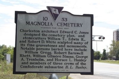
On Meeting Street Road (U.S. 52) near Cunnington Avenue, on the right when traveling north.
(Front text)
Magnolia Cemetery, established in 1850, was named for Magnolia Umbra Plantation, dating back to 1784. The ca. 1800 house built by Col. William Cunnington serves as the cemetery office. This is a fine example of the "rural . . . — — Map (db m23280) HM
Near Long Point Road 0.6 miles west of U.S. 17 when traveling south.
Marker is on the farmhouse porch at north entrance):
Charles Pinckney National Historic Site honors Charles Pinckney honors Charles Pinckney of South Carolina, one of the drafters and signers of the Constitution of the United States. . . . — — Map (db m30544) HM
On Ace Basin Pkwy (U.S. 17) 0.1 miles south of Green Pond Highway (State Highway 303), on the left when traveling north.
On top of this ridge stood a sylvan temple erected before the Revolution by Colonel Barnard Elliott, patriot and sportsman. The structure was supported by columns in the classic manor. The site, a part of Colonel Elliot's plantation "Belleview," . . . — — Map (db m7869) HM
On Broad Street at Meeting Street, on the right when traveling east on Broad Street.
Entered on the National Register of
Historic Places
August 13, 1974
U.S. Post Office and Courthouse
Charleston, South Carolina
John H. Devereux
Architect 1896
This property significantly contributes to the . . . — — Map (db m27449) HM
A place where...Africans were brought to this country under extreme conditions of human bondage and degradation. Tens of thousands of captives arrived on Sullivan's Island from the West African shores between 1700 and 1775. Those who remained in . . . — — Map (db m19123) HM
In memory of the first person, a young girl whose name is unknown. Buried here about 1760. The story goes that she was visiting the Lesly family and died as a result of injuries sustained while they were making lye soap. John Lesly and his . . . — — Map (db m18756) HM
On Greenville Street (State Highway 20) near Beltline Road (County Road S-1-35).
[Front]:
This cemetery, sometimes called Upper Long Cane Cemetery, dates from 1760. It includes the graves of some of the most prominent families of this area from the Colonial era to the present. The first marked grave is the field . . . — — Map (db m50740) HM
On King Street just south of Lamboll Street, on the left when traveling south.
The Nathaniel Ingraham (1759-1818) family owned this property for close to fifty years. Nathaniel Ingraham, originally of Boston, was a naval captain during the Revolutionary War. During his years of service he sailed on the Bon Homme . . . — — Map (db m265393) HM
Side A At midnight on September 21, 1989, Hurricane Hugo, a category four storm, blew into Charleston County. Winds in excess of 140 mph, a massive 20 foot storm surge, and extraordinarily high tides ravaged the area. Hugo cut a swath 50 . . . — — Map (db m37820) HM
On this site stood two successive meeting houses and the burial ground of the Society of Friends or Quakers. The site was deeded to the Quakers circa 1681 by South Carolina Governor John Archdale, a prominent Charleston Quaker and owner of a . . . — — Map (db m47876) HM
On Station 22 1/2 Street (State Highway 703) north of Myrtle Avenue, on the left when traveling south.
[Marker Front]:
In this cemetery are the remains of some of Sullivan's Island's original Islanders, people of predominantly African American descent whose history parallels that of the Island.
Buried here are Carpenters, Cooks, . . . — — Map (db m19117) HM
Statesman • Diplomat • Naturalist
Founder, National Institution for the
Promotion of Science, forerunner of
the Smithsonian Institution
• First United States Minister to Mexico •
• United States Secretary of War •
While serving . . . — — Map (db m8087) HM
On South Main Street at West Court Street on South Main Street.
[Front]:
Born in Charleston, S.C., educated in this country and Great Britain, he travelled widely in Europe and Asia before returning to a distinguished career. He served South Carolina in the state legislature, 1816-1820; 1830-1832; . . . — — Map (db m9187) HM
On Cumberland Street, on the left when traveling west.
First brick house erected in Charleston standing in 1709. Home of Nicholas Trott first Attorney General of the Province of Carolina 1698 to 1702 and Chief Justice 1713 to 1719. — — Map (db m47922) HM
[Main marker]:
In Memory of
81st Wildcat Division
which trained at Camp Sevier,
Apr to July 1918
Maj. Gen. Chas. J. Bailey,
commanding.
[Plaque at foot of marker]:
Camp Sevier
Camp Sevier, a WWI National . . . — — Map (db m8151) HM
On Wade Hampton Boulevard (U.S. 29) at Artillery Road, on the left when traveling north on Wade Hampton Boulevard.
This camp, named in honor of John Sevier, Lieut. Col., N.C. militia, 1777, Col., 1781, Brig. Gen., U.S.P.A., 1796, was approved as cantonment site May 21, 1917. The 30th Division trained here from August 28, 1917 to May 1, 1918; the 81st, from May . . . — — Map (db m10475) HM
On Middle Street, on the right when traveling west.
Down the walk on your left is the grave of General William Moultrie, a citizen of Charleston, who on June 28, 1776 led American troops in the defense of the city. From the walls of the unfinished palmetto log fort on Sullivan's Island he won a . . . — — Map (db m31915) HM
Near Middle Street west of Station 13 Street, on the right when traveling west.
Major General William Moultrie
1730 - 1805
Commander of
Second South Carolina Regiment
During the Battle of Sullivan's Island
June 28, 1776
When offered inducements by Lord Charles
Montagu to desert the American cause,
General . . . — — Map (db m108527)
Near Stumphouse Tunnel Road near State Highway 28, on the right when traveling west.
[Listed from north to south]
Oconee Located on the edge of the Blue Ridge Mountains, Oconee County is known for nature-based activities such as boating, birding, backpacking, and camping
Pickens Pickens County has many beautiful . . . — — Map (db m185421) HM
On Harry M. Hallman, Jr. Blvd, on the right when traveling south.
(Front text)
Born in Greenwood, SC, on July 30, 1934, Harry M.
Hallman, Jr., dedicated much of his adult life to
public service. He was elected Mayor of the Town of
Mount Pleasant in 2000. Mayor Hallman's
administration was responsible . . . — — Map (db m37968) HM
On State Street (U.S. 176) at Depot Street, on the left when traveling east on State Street.
The rural 19th Century village began as a sparsely settled community in historic St. James, Goose Creek Parish of the Charleston District. Following the revolutionary War, increased numbers of settlers entered the parish's backcountry where it . . . — — Map (db m22505) HM
Near Meeting Street near Broad Street, on the right.
George Washington was born in Virginia on February 22, 1732. As a boy, he excelled in field sports, and though
his formal education was limited, he exhibited skill in mathematics and surveying.
In the French and Indian War, though only 23, . . . — — Map (db m47791) HM
On Broadway Street (State Highway 37-203) at Palmetto Avenue, on the left when traveling east on Broadway Street.
The citizens of Newry had been having church service in the hall over the company store for a good while after the village was built. They petitioned the company to allow them to start a building fund, which was agreed to. However, the management . . . — — Map (db m56561) HM
Thin black lines indicate changes in relevance. Between each pair of lines entries are ordered geographically but all have the same relevance.
* Inflectional forms of words are their plurals, singulars, and possessives as well as gramatical tenses and similar variations.