Near Veterans Drive east of Forte Strade, on the right when traveling east.
Built in 1874 to replace a wooden
structure, this neo-classical building
served as a military barracks for Fort
Christian. It later housed the Charlotte
Amalie High School, and today the
Virgin Islands Legislature. A grand
staircase with . . . — — Map (db m193621) HM
On Tolbod Pldn just east of Forte Strade, on the right when traveling east.
A Brief History…
Fort Christian, at the grand age of 326 years, is the oldest standing structure in continuous use in the Virgin Islands and the oldest Danish fortication under the American flag. In 1977, Fort Christian was designated a . . . — — Map (db m40333) HM
On Norre Gade at Kirke Strade, on the right when traveling west on Norre Gade.
In 1666, the same year that the Danish West India Company took possession of St. Thomas, this congregation was founded by Pastor K.J. Slagelse as an outpost of the Evangelical (Lutheran) State Church of Denmark. Worshipping at first in private . . . — — Map (db m40615) HM
Built before 1725, the Frederick Church Parsonage is one of the oldest homes on St. Thomas in continual use since construction. It is situated next to Government House and directly north of Frederick Church and Fort Christian. Its location bears . . . — — Map (db m229190) HM
Near Tolbod Gade south of Tolbod Pladsen, on the left when traveling south.
In the Virgin Islands there landed on 4 April 1607 for a stay of 3 days, a company of 144 Englishmen bound for Virginia. On 13 May 1607 that same group founded at Jamestown, Virginia, the first permanent English settlement beyond the British Isles. . . . — — Map (db m193617) HM
Near Veterans Drive just east of Palm Passage, on the left when traveling east.
In the late 1600s detractors of the Danish Colony referred
to St. Thomas with justification as "The Den of Pirates".
Pirates performed acts of bloody violence. Times glossed over their
crimes and imbued them with romance. Titillating legends . . . — — Map (db m193622) HM
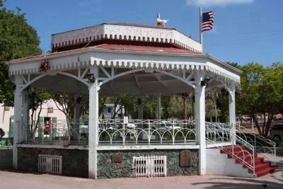
1904 1969
This Bandstand is Dedicated
to the memory of
David E. Monsanto
Bandmaster
St. Thomas Community Band
1935 - 1969
Pursuant to the Act. No. 2804 Bill No. 4534
8th Legislature of the V.I. of the U.S.
His was a life of . . . — — Map (db m40457) HM
Dedicated To You, A Free Citizen In A Free Land
This reproduction of the Liberty Bell was presented to the People of the
Virgin Islands
By the direction of
The Honorable John W. Snyder
Secretary of the Treasury
It was the . . . — — Map (db m40456) HM
On Nye Gade at Krystal Street, on the right when traveling north on Nye Gade.
The St. Thomas Reformed Church is the
oldest congregation in the Virgin Islands and
a member of the oldest denomination with a
continuous ministry in the United States.
Organized by Dutch traders, the first
European settlers, as the St. . . . — — Map (db m193619) HM
On Norre Gade west of Torvet State Road, on the right when traveling west.
Originally built as a private home in Danish Manor style, it was acquired by Frederick Church in 1908.
Bethania has been used by the congregation as a home for the aged and parochial school. It has served the community as a post office and . . . — — Map (db m193618) HM