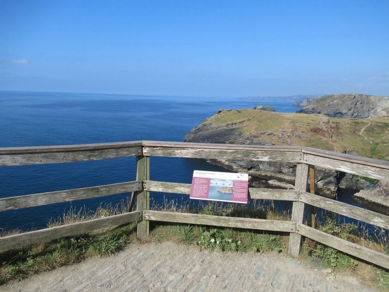
A Changing coastline
Arvor ow chanjya
Looking north-east, this spectacular view tells a story about the complex geology and changing shape of this north Cornwall coast.
The slates and siltstones that make up this coastline were . . . — — Map (db m124105) HM
Great Hall
A complicated ruin
Magor gomplek
The ruins in front of you are the remains of a series of successive halls and service buildings that once stood at the centre of the castle.
The original Great Hall was built in about 1230 and was . . . — — Map (db m124064) HM
Garden
A romantic retreat
Argel romansek
This walled garden was probably built in the 1230s and may have been part of a romantic literary landscape.
Gardening was taken up enthusiastically by English royalty in the 13th century. This . . . — — Map (db m124104) HM
Excavations and discoveries
Kowansow ha diskudhansow
This small hut was built for the site custodian shortly after excavations on the headland were completed in the 1930s.
These excavations, led by CA Ralegh Radford between 1933 and . . . — — Map (db m124107) HM
Florence’s shelter
Skovva Florence
Built in about 1900, this shelter provided welcome protection from the wind and rain for the ‘keeper of the keys’, Florence Nightingale Richards (b.1856).
Like her mother and grandmother before her, she . . . — — Map (db m124063) HM
Great Hall
Prince Dafydd's tale
Hwedhel Pennsevik Dafydd
It is a windy day in October 1242. Servants and tradesmen are busy bringing deliveries of food and barrels of wine, preparing for a feast.
You are standing in the island courtyard of . . . — — Map (db m124062) HM
The Haven
An Harber
The beach and headland at Tintagel appear to be wild and remote today, a haven for coastal plants and animals. But in the 19th century this area saw intensive use for mining, slate quarrying and fishing.
Beyond . . . — — Map (db m124110) HM
Dark Age Buildings
The northern ruins
An magoryow kledh
When this area was cleared by Ralegh Radford's workmen in the 1930s, they found the walls of several simple buildings. We do not know the date of these structures but they probably . . . — — Map (db m124068) HM
Chapel
The Priest's tale
Hwedhel an Pronter
In the driving rain, the weary priest makes his way to the chapel, as he has done every day for years. Today, in November 1361, he resolves that he won't spend another winter on this lonely, . . . — — Map (db m124071) HM
Gatehouse Courtyard
The Sheriff's tale
Hwedhel an Mer
It is an autumn day in 1306. Thomas de la Hyde, sheriff and steward of Cornwall, is visiting the castle to check on the progress and costs of building repairs.
Arriving on horseback, . . . — — Map (db m124060) HM
Dark Age Buildings
The Trader's tale
Hwedhel an Gwikor
A wooden sailing ship, laden with goods from the Mediterranean, is being unloaded down at the deep harbour. There are shouts in unfamiliar languages as large jars are brought up the steep . . . — — Map (db m124065) HM
Tintagel village
Tre War Venydh
The village of Tintagel, once known as Trevena, has been enormously influenced by the presence of the castle since it was built in the 1230s.
The medieval village of Trevena was enhanced by Earl Richard who . . . — — Map (db m124066) HM
Tunnel
Kowfordh
This tunnel is puzzling. Marks on the inside show that it was cut with metal tools, perhaps enlarging a natural cave.
It could have been a food store for the castle or perhaps a mysterious garden feature. — — Map (db m124069) HM
Upper courtyard
Garth gwartha
Soon after this part of the castle was built, the sea-cliff to your right collapsed, taking part of the medieval wall with it. The new wall built to replace it included two latrines that projected over the . . . — — Map (db m124061) HM
Well
Puth
This well is 5.5m deep. It was probably built at the same time as the castle, in the 13th century.
It is fed from natural springs, which emerge across the island. These springs would have provided fresh water for both the Dark Age . . . — — Map (db m124070) HM
Tintagel Castle has long been connected with the mythical King Arthur and its history is entwined with legend. But what really happened here?
In the 5th and 6th centuries AD there was a large, high-status settlement on the headland. It was . . . — — Map (db m124109) HM