On Grant Drive, 0.1 miles north of Brock Road (County Route 613), on the left when traveling south.
"Nothing in history equals this contest. Desperate, long and deadly, it still goes on. From morn till night, nor ends the carnage there -- all night it goes on too. I cannot tell you any of the particulars. You could not understand it. I do not . . . — — Map (db m10708) HM
On Grant Drive, 0.1 miles north of Brock Road (County Route 613), on the left when traveling north.
A Different Kind of War With the 1864 Overland Campaign, the war in Virginia changed. The old pattern of fight, retreat, and rest yielded to Ulysses S. Grant's relentless maneuvering and fighting. Attacked in superior force by an incessant foe, . . . — — Map (db m10716) HM
On Grant Drive, 0.1 miles north of Brock Road (County Route 613), on the left when traveling north.
If It Takes All Summer Grant's failure to win the race to Spotsylvania led to two weeks of brutal combat. Aggressive and impatient, the Union commander relentlessly hammered away at the entrenched Confederate line, looking for weakness. Laurel . . . — — Map (db m10735) HM
On Grant Drive, 0.1 miles north of Brock Road (County Route 613), on the left when traveling north.
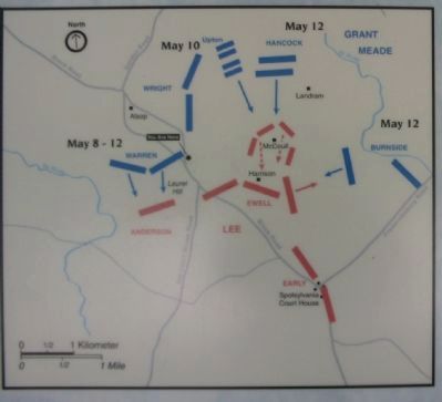
Assault on the Muleshoe Emory Upton's success on May 10 prompted Grant to repeat the attack on a much larger scale. This time the target of the assault was the Muleshoe Salient, a huge outward bulge in the center of the Confederate line. If . . . — — Map (db m10736) HM
On Grant Drive, 0.1 miles north of Brock Road (County Route 613), on the left when traveling north.
No Turning Back Defeated but undeterred, Grant abandoned Spotsylvania's blood-soaked fields on May 21 and continued south -- toward Richmond and ultimate victory. In his wake he left a scarred landscape pitted with thousands of graves.
The . . . — — Map (db m10740) HM
On Grant Drive at Brock Road (County Route 613), on the right when traveling north on Grant Drive.
May 8, 1864. Here began the second delay on Grant's bloody road to Richmond. Having failed to crush Lee in the Wilderness, the Federals attempted to outflank the Confederates by way of Spotsylvania Court House. After a hard night's march, harassed . . . — — Map (db m10199) HM
On Grant Drive at Brock Road (County Route 613), on the right when traveling north on Grant Drive.
May 9-14, 1864. The village of Spotsylvania Court House, two miles farther down the Brock Road, became of utmost temporary importance, since it now protected Lee's communications with Richmond. As the Confederates threw up earthworks around the . . . — — Map (db m10205) HM
On Grant Drive at Brock Road (County Route 613), on the left when traveling north on Grant Drive.
(North face): Erected to commemorate this spot where Maj Genl John Sedgwick, U.S. Vols. Commanding Sixth Army Corps was killed in action on the morning of the 9th of May 1864.
(East face): A tribute to a beloved Commander by the . . . — — Map (db m195808) HM WM
On Brock Road (County Route 613) near Grant Drive, on the right when traveling west.
Maj. Gen. John Sedgwick, commander of the Sixth Corps, was one of the most popular senior officers in the Army of the Potomac. On the morning of May 9, 1864, Sedgwick arrived here to direct some minor redeployment of his troops. Ignoring warnings . . . — — Map (db m181509) HM
On Hancock Road, 0.1 miles south of Brock Road (County Route 613), on the left when traveling south.
Union Gen. G.K. Warren's V Corps occupied this line in the early phases of the Spotsylvania operations. Despite hard fighting, Warren could not break the Confederate line on this front. During the dark and rainy night of May 13, 1864, the V Corps . . . — — Map (db m10213) HM
Near Brock Road (County Route 613) 0.2 miles south of Hancock Road, on the right when traveling south.
A large frame house belonging to Sarah Spindle stood here in 1864. The opening engagement of the Spotsylvania Campaign swirled across the Spindle Farm on the morning of May 8 as Union troops dashed through these open fields toward the Confederate . . . — — Map (db m10252) HM
Near Brock Road (County Route 613) 0.2 miles south of Hancock Road, on the right when traveling south.
Many Spotsylvania families lost property during the war, but Sarah Spindle nearly lost her life. The 36-year-old widow and her family had just sat down to breakfast on May 8, 1864, when the popping of rifles announced the presence of hostile . . . — — Map (db m10253) HM
Near Pritchett Road, 0.1 miles west of Block House Road (County Route 648), on the right when traveling west.
Judge Charles E. Phelps of the Maryland Court of Appeals erected this granite monument shortly after the turn of the century. On May 8, 1864, Phelps, then colonel of the 7th Maryland, helped lead the headlong charge of the Maryland Brigade across . . . — — Map (db m10255) HM