On Washington Highway (U.S. 1), on the right when traveling south.
Approaching Richmond from the north after the Wilderness Campaign, Lt. General U.S. Grant sought to cross the North Anna River and capture the critical rail center at Hanover Junction (Doswell). General R. E. Lee ordered the construction of a . . . — — Map (db m14867) HM
On Massaponax Church Road (County Route 608) 0 miles west of U.S. 1, on the right when traveling west.
Massaponax Baptist Church, built in 1859, served a congregation founded in 1788. On 21 May 1864 Lt. Gen. Ulysses S. Grant and his commanders conferred on pews in the churchyard as the Union army marched from the Spotsylvania Court House battlefield . . . — — Map (db m1719) HM
On Massaponax Church Road (County Route 608) 0 miles west of U.S. 1, on the right when traveling west.
Two weeks of fighting at Spotsylvania had resulted in a bloody draw. On May 21, 1864, the Army of the Potomac left its trenches outside the village and began moving east and south, hoping to lure the Confederates into the open where it could attack . . . — — Map (db m1726) HM
On Jefferson Davis Highway (U.S. 1) 0.1 miles south of Massaponax Church Road (County Route 608), on the left when traveling south.
On 4 May 1863, the ambulance bearing wounded Confederate Maj. Gen. Thomas J. (“Stonewall”) Jackson from the Chancellorsville battlefield turned east here en route to Guinea Station, where he died on 10 May. A year later, Union troops of the Army of . . . — — Map (db m1717) HM
On Guinea Station Road, on the right when traveling east.
Union troops took this road on May 21, 1864, as they left Spotsylvania and headed toward Guinea Station. One year earlier, “Stonewall” Jackson’s ambulance had used this same road to carry the wounded Confederate general from a field hospital in . . . — — Map (db m3707) HM
Near Stonewall Jackson Road (Virginia Route 606) near Guinea Station Road (Virginia Route 634).
General Winfield Hancock’s Union Second corps left Spotsylvania Court House after sunset on May 290, 1864. It trudged south along dark roads, headed toward Milford Station on the Richmond, Fredericksburg, and Potomac Railroad. Grant had ordered . . . — — Map (db m3308) HM
On South River Road, on the right when traveling south.
"At the church…the 9th Corps was marching past, and Burnside was sitting, like a comfortable abbot, in one of the pews, surrounded by his buckish staff whose appearance is the reverse of clerical.” – Theodore Lyman, aide-de-camp . . . — — Map (db m116535) HM
On North Main Street (Virginia Route 2) at Courthouse Lane (Local Route 1204), on the right when traveling north on North Main Street.
On May 21, 1864, Gen. Winfield S. Hancock’s Second Corps passed through Bowling Green. Union soldiers broke into stores, looted homes and freed prisoners from the jail. Documents from the ransacked courthouse littered the streets.
A few bold . . . — — Map (db m207703) HM
On Colonial Road at Antioch Road, on the right when traveling south on Colonial Road.
Unable to crack Confederate Gen. Robert E. Lee’s strongly fortified lines at Spotsylvania Court House, Union Gen. Grant ordered Gen. Winfield Hancock’s Second Corps to cross the Mattaponi River here at Milford Station and threaten the Confederate . . . — — Map (db m116534) HM
On Jefferson Davis Highway (U.S. 1) 2.4 miles south of Guinea Station Road (County Route 607), on the left when traveling south.
Unable to defeat the Confederates at Spotsylvania Court House, on 21 May 1864 Lt. Gen. Ulysses S. Grant ordered the Army of the Potomac to march toward Bowling Green. Maj. Gen. Ambrose E. Burnside’s Ninth Corps brought up the rear. Grant ordered . . . — — Map (db m1722) HM
On U.S. 1, 0.1 miles south of Morris Road (County Route 606).
Mud Tavern was the old name of this place. Six miles east, at Guinea Station, Stonewall Jackson died, May 10, 1863. In the campaign of 1864, Ewell’s and Longstreet’s corps of Lee’s army, coming from Spotsylvania Courthouse, here turned south, May . . . — — Map (db m1720) HM
On Jefferson Davis Highway (U.S. 1), on the right when traveling north.
Here, on May 9, 1864, Sheridan was attacked by Wickham’s cavalry. Nearby, on May 22, 1864, Warren’s (Fifth) Corps, moving to the North Anna, fought Rosser's cavalry. — — Map (db m3320) HM
On Jefferson Davis Hwy (U.S. 1) at Paige Road (Virginia Route 605), on the right when traveling north on Jefferson Davis Hwy.
A little to the east, at Nancy Wright's, Warren's (Fifth) and Wright's (Sixth) Corps, coming from the east, on May 22, 1864, turned south. Wright camped here on May 22. — — Map (db m3318) HM
On Jefferson Davis Highway (U.S. 1) at Virginia Route 639, on the right when traveling south on Jefferson Davis Highway.
Unable to defeat Gen. Robert E. Lee's Confederates during the Spotsylvania Courthouse battles 8-19 May 1864, Union commander Lt. Gen. Ulysses S. Grant's forces maneuvered east and south forcing Lee to abandon his entrenched position. The . . . — — Map (db m9214) HM
On Jefferson Davis Highway (U.S. 1) 0.7 miles south of C C C Road (County Route 683), on the right when traveling north.
Lee camped here, on May 21, 1864, on his way to the North Anna to oppose Grant moving southward. Ewell's and Longstreet's corps rested here that night. — — Map (db m10648) HM
On Jefferson Davis Highway (U.S. 1) at Jericho Road (Virginia Route 207), on the right when traveling south on Jefferson Davis Highway.
Here, at Mount Carmel Church, on May 23, 1864, Hancock’s (Second) Corps turned south to the North Anna River; Warren’s (Fifth) Corps and Wright’s (Sixth) Corps here turned west to Jericho Mills on the River. Grant had his headquarters in the church . . . — — Map (db m3696) HM
On Jericho Road (Virginia Route 207) at Jefferson Davis Highway (U.S. 1), on the left when traveling south on Jericho Road.
The scattered corps of the Union army reunited here at Carmel Church (known during the war as Mount Carmel Church) on May 23 before attacking Confederate Gen. Robert E. Lee across the North Anna River, approximately three miles ahead. Gen. Winfield . . . — — Map (db m3693) HM
On Washington Highway (U.S. 1) at Oxford Road, on the right when traveling north on Washington Highway.
The earthworks in the angle between this stream and the North Anna River, held by a small Confederate force, were taken by Grant's troops moving southward on May 23, 1864. The Unionists then advanced to the river, on the south side of which was . . . — — Map (db m86146) HM
On Washington Highway (U.S. 1), on the right when traveling north.
Lee and Grant faced each other on the North Anna, May 23-26, 1864. Union forces crossed here and four miles to the west but found they could not dislodge Lee's center, which rested on the stream. Grant then turned east to Cold Harbor. — — Map (db m10644) HM
Near Verdon Road (Virginia Route 685) 0.2 miles west of New Market Mill Road, on the right when traveling west.
(west side of Marker): The Fight for North Anna On May 21, 1864, Union General Ulysses S. Grant directed the Army of the Potomac away from Spotsylvania Court House in a turning movement toward Hanover Junction, today known as Doswell. . . . — — Map (db m15164) HM
Near Verdon Road (Virginia Route 685) 0.2 miles west of New Market Mill Road, on the right when traveling west.
This monument honors all the valiant men who lost their lives on the battlefields of the North Anna May 23-26, 1864 “No more shall the war cry sever, or the winding rivers be red; They banish our anger forever when they laurel the graves of . . . — — Map (db m15167) HM
Near Verndon Road (Virginia Route 684) 0.2 miles west of New Market Mill Road (Virginia Route 685), on the right when traveling west.
At 11:00 a.m. six cannon of Major John Lane’s Georgia artillery battalion, followed closely by Brigadier General Edward A. Perry’s weakened 270-man Florida infantry brigade, moved down this road to cover the vital crossing of Ox Ford. As the Union . . . — — Map (db m20946) HM
Near Verndon Road (Virginia Route 684) 0.2 miles west of New Market Mill Road (Virginia Route 685), on the right when traveling west.
The five Virginia regiments led by Colonel David A. Weisiger began construction of the trenches before you on the morning of May 24 and continued to work on them during the next two days. The Virginians had been resting quietly near Anderson’s . . . — — Map (db m74893) HM
Near Verndon Road (Virginia Route 684) 0.2 miles west of New Market Mill Road (Virginia Route 685), on the right when traveling west.
Grant misinterpreted Lee’s withdrawal on May 23 and 24 as Confederate weakness and ordered the Army of the Potomac to brush aside any scattered Rebel resistance and advance to Richmond. Major General Ambrose E. Burnside received orders to move his . . . — — Map (db m20953) HM
Near Verndon Road (Virginia Route 684) 0.2 miles west of New Market Mill Road (Virginia Route 685), on the right when traveling west.
The first unit of the Union Ninth Corps to cross the North Anna was Brigadier General James H. Ledlie’s brigade. His 1,500 infantrymen were ready to advance by 3:00 p.m., despite having been soaked up to their armpits while crossing the river. . . . — — Map (db m20955) HM
Near Verndon Road (Virginia Route 684) 0.2 miles west of New Market Mill Road (Virginia Route 685), on the right when traveling west.
The trenches before you were manned by the soldiers of Brigadier General Nathaniel Harris’ brigade of Mississippians, who had deployed just to the right of Sanders’ Alabamians by 1:00 p.m. on the 24th. The small pits behind the trench line served as . . . — — Map (db m20956) HM
Near Verndon Road (Virginia Route 684) 0.2 miles west of New Market Mill Road (Virginia Route 685), on the right when traveling west.
Despite the disaster that had befallen the 35th Massachusetts, General Ledlie became even more determined to secure Ox Ford. Against the orders of his division commander, the drunken general ordered his unsupported brigade to assault the Confederate . . . — — Map (db m20957) HM
Near Verndon Road (Virginia Route 684) 0.2 miles west of New Market Mill Road (Virginia Route 685), on the right when traveling west.
As the imperiled Union brigade huddled in the ravine before you, General Mahone recognized that their bold assault was unsupported and ordered General Harris to send a regiment from these trenches to attack them. At 6:45 p.m. the 12th Mississippi . . . — — Map (db m20959) HM
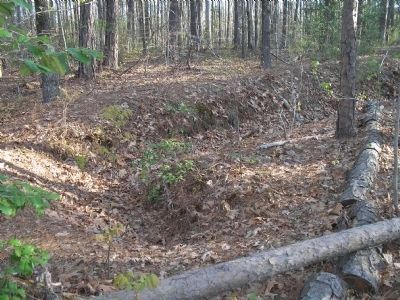
Near Verndon Road (Virginia Route 684) 0.2 miles west of New Market Mill Road (Virginia Route 685), on the right when traveling west.
You are now standing in the tip of the famous “inverted V” position constructed by Lee’s army along the North Anna River. The trenches on your left continued to the Little River, while those on the right anchored on a bend in the North Anna below . . . — — Map (db m20961) HM
Near Verndon Road (Virginia Route 684) 0.2 miles west of New Market Mill Road (Virginia Route 685), on the right when traveling west.
From the gun pits served by McIntosh’s artillery battalion, you can easily see the natural strength of the Confederate position. The repulse of Ledlie’s brigade served as a warning to Grant that Lee was still on the North Anna in great strength and . . . — — Map (db m20967) HM
Near Verndon Road (Virginia Route 864) 0.2 miles west of New Market Mill Road (Virginia Route 865), on the right when traveling west.
You are standing before the trench line of the 10th Georgia Battalion, which held the right flank of Wright’s brigade. The Florida brigade and Lane’s artillery battalion held the position across the ravine to your right. On May 25 and 26 cannon and . . . — — Map (db m20971) HM
On Washington Highway (U.S. 1), on the left when traveling south.
Two 19th-century railroads crossed at grade level just east: the Richmond, Fredericksburg & Potomac and the Virginia Central, which ran west to the Shenandoah Valley, the Confederacy’s breadbasket during the Civil War. This junction attained . . . — — Map (db m14864) HM
On Virginia Route 30, on the left when traveling east. Reported missing.
This junction was one of the most pivotal sites for the well-being of Confederate Gen. Robert E. Lee’s army. Known during the war as Hanover Junction, it was the intersection of two important railroads. The Richmond, Fredericksburg and Potomac . . . — — Map (db m125005) HM
On Washington Highway (U.S. 1) 0.2 miles south of Kings Dominion Boulevard (Virginia Route 30), on the right when traveling north.
A short distance east, at Taylorsville, Lee had his headquarters, May 24–26, 1864, as his army moved southeastward to intervene between Grant and Richmond. There Ewell’s Corps turned to Cold Harbor, May 27, 1864. — — Map (db m10641) HM
On North Washington Highway (U.S. 1) 0.2 miles north of Cross Corner Road, on the right when traveling north.
Following the Union army's departure from the North Anna River on 26 May 1864, Confederate Gen. Robert E. Lee cautiously moved his army south toward Richmond to stay between the Federals and the capital. Lee's wagon trains, using nearby Ellett's . . . — — Map (db m17788) HM