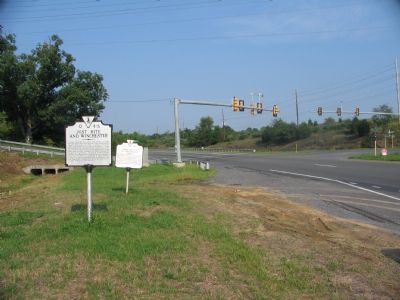
On Berryville Pike (Virginia Route 7) at Greewood Road (County Route 656), on the right when traveling east on Berryville Pike.
Here Confederate forces under General Jubal A. Early, facing east, received the attack of Sheridan’s army at noon on September 19, 1864. Early repulsed the attack and countercharged, breaking the Union line. Only prompt action by General Emory Upton . . . — — Map (db m2268) HM
On Berryville Pike (Virginia Route 7) at Cole Lane, on the right when traveling west on Berryville Pike.
On a hill, approximately one-half mile to the west, Philip H. Sheridan established his final position on September 19, 1864. General Jubal A. Early held the ground one-half mile further to the west. At 4 P.M., Sheridan advanced with massed cavalry . . . — — Map (db m2271) HM
On Redbud Road (County Route 661), on the right when traveling east. Reported permanently removed.
The Third Battle of Winchester, fought here on September 19, 1864, was a proving ground for several men on both sides who shaped post-war America. They included two future presidents, two senators, a state governor, and several military leaders. . . . — — Map (db m155042) HM
On Milburn Road (County Route 662) at Old Charlestown Road (County Route 761), on the right when traveling south on Milburn Road. Reported missing.
On September 19, 1864, Union Gen. Philip H. Sheridan’s Army of the Shenandoah routed Confederate Gen. Jubal A. Early’s Valley Army at the Third Battle of Winchester (also called Opequon) in the bloodiest and largest battle in the Shenandoah Valley. . . . — — Map (db m100977) HM
On Valley Turnpike (U.S. 11), on the right when traveling south.
The fort on the hilltop to the southwest, known as Star Fort, was taken by Colonel Schoonmaker of Sheridan’s Army in the Battle of September 19, 1864. — — Map (db m2275) HM
On Martinsburg Pike (U.S. 11) at Brooke Road (Route 1322), on the right when traveling south on Martinsburg Pike.
In the late summer of 1864 General Philip H. Sheridan with 41,000 Federals was ordered to take the vital Shenandoah Valley. Opposing this force was a Confederate army of 18,000 under General Jubal A. Early stationed north and east of Winchester. On . . . — — Map (db m155165) HM
On Martinsburg Turnpike (U.S. 11) at Brooke Road (Route 1322), on the right when traveling south on Martinsburg Turnpike.
Just to the east, a redoubt known as Fort Collier was built by Joseph E. Johnston in 1861. Early’s left rested here during the Third Battle of Winchester, September 19, 1864. — — Map (db m2481) HM
On Martinsburg Pike (U.S. 11) at Brooke Road (Route 1322), on the right when traveling north on Martinsburg Pike.
Confederate troops constructed Fort Collier in 1861 after the evacuation of Harpers Ferry. The earthworks, which surrounded the Benjamin Stine house here, commanded the approach to Winchester on the Martinsburg and Winchester Turnpike. The fort saw . . . — — Map (db m2492) HM
Near Martinsburg Pike (U.S. 11) at Brooke Road (County Route 1322), on the right when traveling north.
Lieutenant General Jubal Early’s Shenandoah Valley Campaign began in June of 1864. Until the Third Battle of Winchester on September 19, he more than fulfilled General Lee’s hopes that the great success of 1862 could be repeated in 1864. Early’s . . . — — Map (db m155168) HM
Near Martinsburg Pike (U.S. 11) at Brooke Road (County Route 1322), on the right when traveling north.
The shocking impact of the great charge and capture of Fort Collier unhinged Early’s entire line of battle. Confederate troops streamed south through the streets of Winchester, Confederate artillery continued firing from Star Fort, slowing the . . . — — Map (db m2509) HM
Near Martinsburg Pike (U.S. 11) at Brooke Road (County Route 1322), on the right when traveling north.
General Joseph E. Johnston commanded all Confederate forces in Virginia from 1861 until late in May of 1862. His initial post had been at Harpers Ferry, thought to be the key to the defense of the Shenandoah Valley. Johnston, however, believed that . . . — — Map (db m2508) HM
Near Martinsburg Pike (U.S. 11) at Brooke Road (County Route 1322), on the right when traveling north.
From the time of Virginia’s secession from the Union on May 23, 1861, until just before the Battle of Manassas on July 21, 1861, the Confederate government in Richmond recognized the importance of defending the Lower Shenandoah Valley. When . . . — — Map (db m192240) HM
On North Loudoun Street at East Fairfax Lane, on the right when traveling north on North Loudoun Street. Reported missing.
In September 1864, U.S. Gen. Philip H. Sheridan heard rumors that Confederate forces had left the Shenandoah Valley to rejoin Gen. Robert E. Lee’s army at Petersburg. Wanting to confirm this information before attacking Gen. Jubal A. Early’s army, . . . — — Map (db m226362) HM
On National Avenue (State Highway 7), on the right when traveling east.
Near here Early, facing east, took his last position on September 19, 1864. About sundown he was attacked and driven from it, retreating south. Presidents Rutherford B. Hayes and William McKinley served in this engagement on the Union side. — — Map (db m2656) HM
On Mt Hebron Drive at Confederate Cemetery Drive, on the left when traveling east on Mt Hebron Drive.
(The Battle of the Opequon) September 19, 1864 The decisive assault in the campaign set in motion by General Grant to free the Shenandoah Valley from the control of the Confederacy took place here. This high ground was part of Winchester’s . . . — — Map (db m2660) HM