This marker is trail head for a set of markers along the Balls Bluff Battlefield walking trail. Please use the related markers list here to see a "virtual tour" of the battlefield by markers.
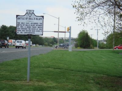
One mile east occurred the Battle of Ball’s Bluff, October 21, 1861. A Union force, which had crossed the river at this point, was driven back over it by the Confederates. — — Map (db m985) HM
On April 12, 1861, with the firing on Fort Sumter, America went to war with itself. Just as the country was divided, so were Virginia and Loudoun County. The western portion of Virginia became the separate state of West Virginia in 1863. Here in . . . — — Map (db m168049) HM
On the night of October 20, 1861, a small Federal scouting party crossed the Potomac River from Maryland to determine whether recent troop movements indicated a Confederate withdrawal from Leesburg. Advancing inland from Ball’s Bluff, the . . . — — Map (db m157212) HM
6 AM - After crossing the river, the 15 MA (Colonel Devens) advanced to the area near the Jackson house, leaving the 20 MA (Colonel Lee) on the bluff to guard the exit path to the river. 8 AM - Captain Duff's (17 MS) Company ran into . . . — — Map (db m27590) HM
1. Sugarloaf Mountain - This was the site of a Union Signal Corps station that remained in operation throughout much of the war. 2. White's Ferry - Originally called Conrad's Ferry, this crossing was established in 1817 about four miles . . . — — Map (db m27839) HM
The 8th Virginia Infantry was a local unit made up of six companies from Loudoun, two from Fauquier, and one each from Fairfax and Prince William counties. Commanded by Colonel Eppa Hunton, the Regiment arrived on the field about 12:30 p.m. . . . — — Map (db m2211) HM
Lieutenant Colonel Walter H. Jenifer commanded the 300-man cavalry force in Colonel Nathan “Shanks” Evan’s Confederate brigade. Jenifer had some 70 troopers with him at Ball’s Bluff, including portions of the Chesterfield Light Dragoons, . . . — — Map (db m2213) HM
The 15th Massachusetts Infantry provided an initial scouting patrol on the night of October 20 and the troops for the raiding party the next morning. Five companies, roughly 300 men, were to attack a Confederate camp. Devens positioned his men . . . — — Map (db m2223) HM
The Federals crossed three pieces of artillery to Ball’s Bluff. Two mountain howitzers from the 2nd New York State Militia, detached under Lt. Frank French of Battery I, 1st U.S. Artillery, occupied this area for much of the afternoon. A 12-pdr . . . — — Map (db m157629) HM
Ball's Bluff is a 600 yard long shale and sandstone cliff. It rises up a shallow bell curve from two ravines approximately 300 yards north and south of where you are standing. At this point, it is about 100 feet high, though just to the north . . . — — Map (db m150419) HM
Companies D and I of the 20th Massachusetts (the “Harvard Regiment”) followed the 15th Massachusetts across the Potomac with orders to serve as a rear guard and cover the withdrawal of the 15th Massachusetts following what was hoped . . . — — Map (db m157271) HM
The 1st California was one of four regiments that made up the “California Brigade” commanded by Colonel Edward D. Baker, U.S. Senator from Oregon and close friend of President Lincoln. In April, 1861, Baker helped to organize what was . . . — — Map (db m2230) HM
Colonel Baker is buried at the Presidio in San Francisco, California. This memorial stone was placed here to mark what was believed to be the location of Baker’s death and to honor the memory of the only U.S. Senator to have died on the field of . . . — — Map (db m2237) HM
The twenty-five graves here in one of America’s smallest national cemeteries contain the partial remains of 54 Union soldiers killed at the Battle of Ball’s Bluff, October 21, 1861. All are unidentified except Pvt. James Allen of Northbridge, . . . — — Map (db m194381) HM
Brigadier General Charles Pomeroy Stone As the overall commander of Union forces at Ball’s Bluff, Stone was a rising star in the Union army at the time of the battle. He became the scapegoat for the defeat. Stone was born September 30, 1824, . . . — — Map (db m157573) HM
Colonel Nathan George “Shanks” Evans Nathan Evans was born in South Carolina in 1824. An 1848 West Point graduate, he was jokingly nicknamed “Shanks” by his classmates because he was knock-kneed. During the next decade . . . — — Map (db m157627) HM
The Battle of Ball’s Bluff was the result of a mistake. The previous evening, Capt. Chase Philbrick, Co. H, 15th Massachusetts, led a small reconnaissance patrol across the river to determine the results of some earlier Confederate troop movements. . . . — — Map (db m157576) HM
Standing over 6'4" and wearing a full red beard, Clinton Hatcher was a memorable figure. Despite his Quaker upbringing, he joined Company F of the 8th Virginia at the beginning of the war and became the regimental color bearer. This combined with . . . — — Map (db m2243) HM
The 42nd New York (“Tammany Regiment”) was commanded by Col. Milton Cogswell, the only West Point-trained officer among the senior Union commanders at Ball’s Bluff. Five companies of the 42nd participated in the battle. With the death . . . — — Map (db m157216) HM
The 17th Mississippi Infantry was the last Confederate unit to arrive on the field. These 600-700 fresh troops showed up late in the afternoon and tipped the balance of what had been a hard but evenly fought contest up to that point. The . . . — — Map (db m157213) HM
The 18th Mississippi Infantry was sent from nearby Edward's Ferry and arrived near here around 3:00 p.m. Colonel Erasmus Burt ordered his men forward across the then open field unknowingly into a deadly crossfire between the two wings of the Union . . . — — Map (db m157214) HM
Ball’s Bluff is the only battlefield on which a United States senator was killed in combat. Edward Dickinson Baker, senator from Oregon, was also a colonel and one of Brig. Gen. Charles Stone’s three brigade commanders. Baker was a long-time friend . . . — — Map (db m168045) HM
Two hundred yards to your right are the remains of a small earthwork that may have been part of a masked (concealed) battery which played an important role in the Battle of Ball’s Bluff on October 21, 1861. The battery commanded the road from . . . — — Map (db m156304) HM
Nearby is the likely site of the Confederate “masked battery” (concealed artillery) that was an object of Federal concern early in the Civil War. On 21 Oct. 1861, elements of the 13th Mississippi infantry near there engaged 35 horsemen . . . — — Map (db m167611) HM
In 2004, Ball's Bluff Battlefield Regional Park began a restoration project on the battlefield where you stand today. The objective of the effort is to return about 12 acres of the battlefield to its approximate appearance in 1861. First hand . . . — — Map (db m150412) HM