13 entries match your criteria.
Related Historical Markers
North Anna Battlefield Park "Blue Trail" Markers

By Blue & Gray Education Society
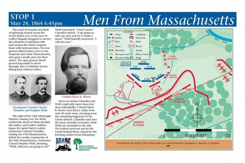
Men From Massachusetts Marker
SHOWN IN SOURCE-SPECIFIED ORDER
| Near Verdon Road (Virginia Route 684) 0.2 miles west of New Market Mill Road (Route 685), on the right when traveling west. |
| Near Verdon Road (Virginia Route 684) 0.2 miles west of New Market Mill Road (Virginia Route 685), on the right when traveling west. |
| Near Verdon Road (State Road 684) 0.2 miles west of New Market Mill Road (State Route 685), on the right when traveling west. |
| Near Verdon Road (Virginia Route 684) 0.2 miles west of New Market Mill Road (Virginia Route 685), on the right when traveling west. |
| Near Verdon Road (Virginia Route 684) 0.2 miles west of New Market Mill Road (Virginia Route 685), on the right when traveling west. |
| Near Verdon Road (Virginia Route 684) 0.2 miles west of New Market Mill Road (Route 685), on the right when traveling west. |
| Near Verdon Road (Virginia Route 684) 0.2 miles west of New Market Mill Road (Virginia Route 685), on the right when traveling west. |
| On Verdon Road (Virginia Route 684) 0.2 miles west of New Market Mill Road (Virginia Route 685), on the right when traveling west. |
| Near Verdon Road (Virginia Route 684) 0.2 miles west of New Market Mill Road (Virginia Route 685), on the right when traveling west. |
| Near Verdon Road (Virginia Route 684) 0.2 miles west of New Market Mill Road (Virginia Route 685), on the right when traveling west. |
| Near Verdon Road (Virginia Route 684) 0.2 miles west of New Market Mill Road (Virginia Route 685), on the right when traveling west. |
| Near Verdon Road (Virginia Route 684) 0.2 miles west of New Market Mill Road (Virginia Route 685), on the right when traveling west. |
| Near Verdon Road (Virginia Route 684) 0.2 miles west of New Market Mill Road (Virginia Route 685), on the right when traveling west. |
May. 3, 2024
