Purchased from a large tract of land belonging to William Penn, William Allen and Joseph Turner started their iron works here in 1760. Slaves and indentured servants were employed to extract and process iron ore to produce fine grade iron. The iron . . . — — Map (db m27297) HM
The Delaware, Lackawanna and Western Railroad started construction on an eleven million dollar connection between Port Morris and Columbia, NJ in 1910. Completed within less than two years, it was an engineering marvel of its time, given that it was . . . — — Map (db m27310) HM
On or about the year 1690 William H. Beemer settled here on 1,000 acres of land and built the first mill. James Haggerty purchased this land in 1793 and built additional successful mills lending the area the name known as "Brantown" due to the many . . . — — Map (db m26446) HM
In this area, on Cat Swamp Hill in Byram Township, at about 6:00 a.m. on June 14, 1921, the Sussex Print Silk truck was hijacked. Albert Koster drove onto the scene on his motorcycle, was mistaken for a state trooper, and murdered. The gang escaped . . . — — Map (db m26354) HM
The Amity School was built in 1840, and in continuous use until June 1936. When it was built, Byram Township included part of current Sparta Township, and all of Stanhope and Hopatcong Boroughs. Stanhope Road did not reach from Green Road to . . . — — Map (db m26433) HM
In 1750, several families left the Congregational Church of Mansfield, CT relocating to New Jersey with William Marsh, their spiritual leader. Building a log meeting house here, they associated with the Baptist faith in 1750. As the church . . . — — Map (db m193425) HM
Dr. Samuel Fowler, born in Newburgh, NY, and came first to Hamburg after medical studies in Philadelphia. He established mills, a blacksmith shop, tannery, and a furnace to process ores from mines owned in Franklin Furnace. He became a noted and . . . — — Map (db m26449) HM
Fredon Township, incorporated in 1904 became the last town in Sussex County and the only so named in the Country. Fredon, a name proposed for our nation in the early 1800's means a place of peace and freedom. The Route 94 crossroads, known as . . . — — Map (db m26453) HM
In 1735, Royal Governor Jonathan Belcher ordered Sussex County's Government and Courts to be moved from Log Gaol to the tavern - house of Thomas Woolverton (1717-1760). Justice of the Peace and Tax Collector, until a permanent Courthouse was erected . . . — — Map (db m27284) HM
In 1768, Joseph Sharp erected a forge and furnace on the Wallkill River. The village around the Sharp Iron Works became known as Sharpsborough, later becoming Hamburg. Due to the expensive nature of the venture and competing forges, Sharp abandoned . . . — — Map (db m26457) HM
Settled c.1750. Named from early inhabitants fondness of snuff tobacco or perhaps because "snuff" was a euphemism for liquor. Windham, Stockholm and other important forges produced iron goods. Paterson & Hamburg Turnpike (organized here 1806) . . . — — Map (db m30659) HM
Maxim Park was the estate of famous inventor, Hudson Maxim. Purchased by Maxim in 1901, the property included a spectacular Venetian boat house, guest cottages, a laboratory, ice house/observatory, servant's quarters, tennis courts and garage. . . . — — Map (db m26455) HM
On this site stood the LaFayette Foundry, built in 1836 by Alexander Boyles. This operation employed many laborers and the success of the industry resulted in the sale of building lots along Union Turnpike (now Route 15) by Joseph Northrup, Jr. and . . . — — Map (db m88587) HM
This central hamlet for Montague, a township created in 1759, was named for the Brick House Hotel - a colonial tavern, hostelry and stage coach stop built in the 1700's. It sat at the convergence of two turnpikes with Old Mine Road and near the . . . — — Map (db m26416) HM
President of the H.W. Merriam Shoe Company, he relocated his factory from New York City to Newton in 1873. The nation's largest producer of ladies' and children's shoes, it was also the largest employer in Sussex County with over 350 employees. Held . . . — — Map (db m26454) HM
The Courthouse Yard was a central part of landowner Jonathan Hampton’s Town Plot in 1762. It was used for political meetings, corporal punishment, militia trainings, public entertainments, and a common pasture. Until 1858 voters in township . . . — — Map (db m8085) HM
The only Colonial county seat in New Jersey where a court house on its original site fronts a town square or public Green.
In 1908 architect J.J. Vreeland added an upper story and Classical porch to the County Clerk and Surrogate Offices, built . . . — — Map (db m27307) HM
In 1887, bordering "The Great Road" (Rt. 94) where Warren and Sussex Counties meet at an elevation 880 feet, a church and manse were erected as the third location of this Presbyterian congregation, built in the Victorian Queen Anne style by Simeon . . . — — Map (db m122282) HM
Two rudimentary bridges were built to cross the Tockhockonetcong (now the Paulinskill) as Jonathan Hampton ordered the construction of the Military Road in 1756. An essential supply line to the frontier fortification in the Delaware Valley, the . . . — — Map (db m27283) HM
Built in 1910 as Ogdensburg's fifth public school, it was adapted for re-use in 1930 as the Borough's first firehouse. In 1989, with the aid of two state grants, the Ogdensburg Historical Society adapted it for re-use and dedicated it as the Old . . . — — Map (db m27303) HM
The original name of "Sandyston" was changed to honor N.J. Governor Haines in 1845. This hamlet was created on a 1,000 acre plot purchased from the Gardner Tract by Simon Courtright before the Revolutionary War. Ownership passed to Peter Hotalen, . . . — — Map (db m26413) HM
Johannes Westbrook, who was among the earliest permanent settlers of the Minisink region, built this homestead around the year 1701. It was subsequently fortified when incidents of hostility increased between the residents of New York and New Jersey . . . — — Map (db m26414) HM
Stanhope was a major port of commerce on the Morris Canal in Sussex County, enabling the expansion of the ironworks industry. The Morris Canal, a man-made engineering achievement, operated 1831-1924, and linked the Hudson and Delaware Rivers, . . . — — Map (db m27299) HM
Casper Shafer, a German emigrant settled this area circa 1742. By 1750, he built this stone house, later fortifying it with a stockade during the French and Indian War. His first grist mill, built 1743, was located upstream, replacing it in 1764 . . . — — Map (db m26448) HM
Sussex Borough was settled by Peter Decker about 1742. It was incorporated from Wantage Township as the Borough of Deckertown on October 15, 1891. The name was changed to Sussex Borough on March 2, 1902. The Sussex Presbyterian Church, the oldest . . . — — Map (db m27298) HM
Here in the Clove in 1857 a filly of Hambletonian lineage was foaled on the farm of John B. Decker. When fully grown, a bay standardbred mare 15 hands, she was bought by Alden Goldsmith of Washingtonville, NY and won her first harness race at Goshen . . . — — Map (db m137325) HM
Built in 1840, Price's Switch School was the last one-room schoolhouse to operate in Sussex County. The building originally stood on Route 94, a quarter mile north of Price's Switch Road, but was moved to its current location in 1883. It is the only . . . — — Map (db m27301) HM
This church was constructed in 1847 at a cost of $1,500 and was officially incorporated in May of 1848. Records of the parish date back to 1832.
Many of the well-known local families were early benefactors, such as Rutherford, Dekay, Price, . . . — — Map (db m27300) HM
Wallpack Township, formed in 1731 out of Hunterdon County, included the present townships of Montague, Sandyston and the former Pahaquarry.
The Delaware River forms the western boundary and the Old Mine Road, supposedly built by Dutch miners . . . — — Map (db m49024) HM
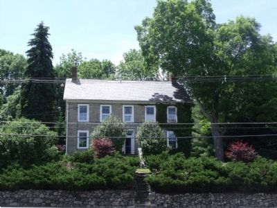
This house was built in 1787 as the home of the Reverend Elias Van Bunschooten, a Dutch Reformed Minister. He was a farmer, mill operator, and large land owner. The farm was part of a 1000 acre plantation. The Dutch Colonial house is post and beam . . . — — Map (db m30664) HM
At the invitation of Major Hugh Judson Kilpatrick (1836-1881), a native of Wantage, over forty thousand veterans of the American Civil War and guards were treated to four days of festivities from August 25-28, 1878. On the final day of the . . . — — Map (db m27305) HM
Enos Brink farmed this foothills at the head of the West Branch of the Papakating Creek from 1835 to 1871. James Turner (1859-1939), of Montclair, retired executive of Arbuckle Brothers, a NY coffee and sugar company, built Lusscroft between 1919 . . . — — Map (db m26451) HM