Marker Logo HMdb.org THE HISTORICAL
MARKER DATABASE
“Bite-Size Bits of Local, National, and Global History”


22 entries match your criteria.  


Manassas Gap Railroad Historical Markers

This Civil War era railroad in Virginia is now a 60 mile Norfolk Southern line that runs from the Lower (Northern) Shenandoah Valley to Manassas.
 
Efe Quality House image, Touch for more information
March 15, 2008
Efe Quality House
1 Virginia, Fairfax — Efe Quality HouseBuilt 1930 — Old Town Fairfax —
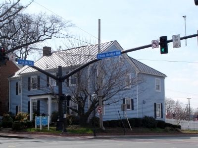
On Chain Bridge Road (Virginia Route 123) at North Street (Virginia Route 236), on the right when traveling south on Chain Bridge Road.
2 Virginia, Fairfax — Manassas Gap Railroad
On Judicial Drive, on the left when traveling south.
3 Virginia, Fairfax County, Annandale — Action At Annandale
On Little River Turnpike (Virginia Route 236) at Hillbrook Drive, on the right when traveling east on Little River Turnpike.
4 Virginia, Fairfax County, Centreville — Manassas Gap RailroadIndependent Line
5 Virginia, Fairfax County, Chantilly — 6 — "Loudoun Branch" of the Historic Manassas Gap Railroad(Unfinished Spur, circa 1851 - 1857) — Sully Historic Site: Cain's Branch Archaeological Trail —
Near Historic Sully Way, 0.8 miles south of Air and Space Museum Parkway, on the left when traveling south.
6 Virginia, Fairfax County, Fairfax — Manassas Gap RailroadIndependent Line
Near Shirley Gate Road (Virginia Route 655) south of U.S. 29, on the left when traveling south.
7 Virginia, Fauquier County, Delaplane — B-21 — Delaplane(Formerly Piedmont Station)
On Rokeby Road (County Route 623) at Winchester Road (U.S. 17), on the right when traveling east on Rokeby Road.
8 Virginia, Fauquier County, Delaplane — Piedmont StationBy Train to Manassas — First Manassas Campaign —
On Delaplane Grade Road at Winchester Road (U.S. 17), on the left when traveling east on Delaplane Grade Road.
9 Virginia, Fauquier County, Rectortown — RectortownMcClellan’s Demise, Mosby’s Raffle — Mosby's Confederacy —
On Maidstone Road, on the left when traveling west.
10 Virginia, Loudoun County, Purcellville — T-53 — Loudoun Branch, Manassas Gap Railroad
On Sands Road (County Route 709) at Manassas Gap Court, on the right when traveling east on Sands Road.
11 Virginia, Manassas — Mayfield Fort1861 - 1864
On Battery Heights Boulevard south of Quarry Road, on the right when traveling north.
12 Virginia, Manassas — Site of Manassas Junction
On Battle Street south of Center Street, on the right when traveling south.
13 Virginia, Manassas — Wartime Manassas“Fortifications of Immense Strength”
On West Street south of Center Street, on the left when traveling south.
14 Virginia, Manassas — Wartime Manassas“On to Richmond!”
On West Street at the railroad tracks, on the right when traveling south on West Street.
15 Virginia, Manassas — Wartime Manassas"Defend that point against an attack"
On Prince William Street at Wellington Road, on the left when traveling west on Prince William Street.
Paid Advertisement
16 Virginia, Manassas — Why the Forts?May 8, 1861
Near Battery Heights Boulevard south of Quarry Road, on the right when traveling north.
17 Virginia, Prince William County, Manassas — “The Unfinished Railroad”
On Sudley Road (Virginia Route 234) south of Featherbed Lane.
18 Virginia, Prince William County, Manassas — CL-5 — Fifth Prince William County Courthouse
On Lee Avenue just south of Grant Avenue (Business Virginia Route 234), on the right when traveling south.
19 Virginia, Prince William County, Manassas — The Rock FightSecond Battle of Manassas — Day Three, August 30, 1862 —
Near Featherbed Lane (continuation of Groveton Road) (County Route 622) 0.5 miles north of Lee Highway (formerly the Warrenton Turnpike) (U.S. 29).
20 Virginia, Prince William County, Manassas — The Unfinished RailroadAttacks on Jackson’s Line — Second Battle of Manassas, Day Two, August 29, 1862 —
Near Featherbed Lane (Groveton-Sudley Road) at General Trimbles Lane (a private road).
21 Virginia, Prince William County, Manassas — The Unfinished Railroad
On Featherbed Lane at General Trimbles Lane (a private road), on the left when traveling south on Featherbed Lane.
22 Virginia, Shenandoah County, Strasburg — Civil War StrasburgStrategic Intersection
On East King Street (Virginia Route 55) 0.1 miles east of Acton Place, on the right when traveling east.
 
 
CeraNet Cloud Computing sponsors the Historical Marker Database.
This website earns income from purchases you make after using our links to Amazon.com. We appreciate your support.
Paid Advertisement
Apr. 30, 2024