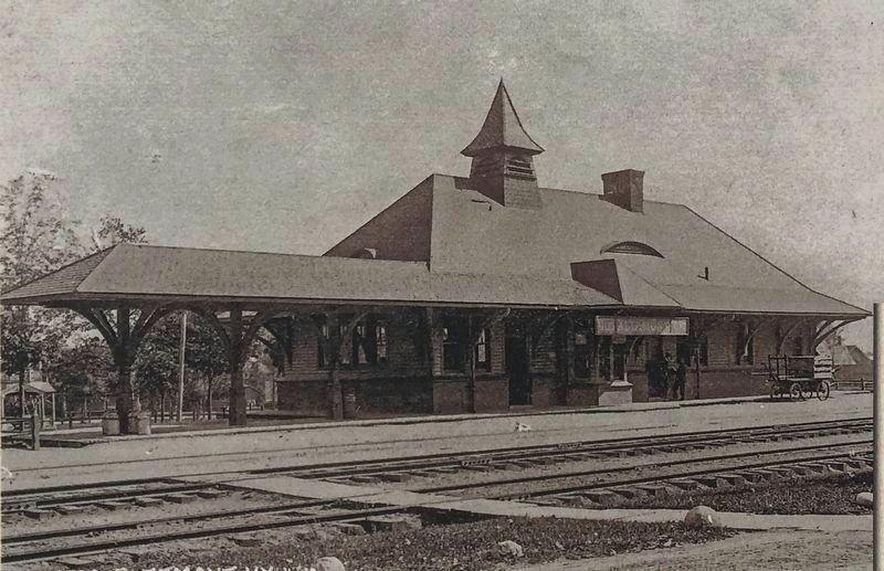
The Village's First Freight and passenger train station was built in 1864, only months after the first train passed through Knowersville. In 1896 the old station was moved south along the tracks. In 1897, it was replaced by the . . . — — Map (db m115732) HM
Welcome to Altamont
The Village of Altamont and its immediate surroundings were once part of a tract of land deeded in 1630 by the Dutch West India Company to Killian Van Rensselaer (c. 1586-1643),a wealthy 17th century Dutch . . . — — Map (db m132693) HM
In 1887, Charles V. Beebe received a patent for an easy riding, swing attachment for farm equipment seats. In 1891,he moved to Altamont and opened a harness shop in the Ostrander Building, in what is now 125 Maple Avenue. In 1895, . . . — — Map (db m131475) HM
In 1867, George Severson, a great-grandson of early settler Jurrian Severson, built the Severson House hotel, the first hotel in the growing hamlet of Knowersville. Only a few steps away from the new train station, the hotel provided lodging . . . — — Map (db m246180) HM
In 1879, James Ostrander bought a large lot on Church Street, and built a thriving shoe business. In 1882, he sold a portion of the lot to Charles Taber, who opened a tin shop on the site. Both businesses were lost in the 1886 fire, . . . — — Map (db m131455) HM
The Altamont Hose Company No. 1 was organized in May 1893, with 25 citizens appointed as members by the Village Trustees. The Company's first location was rented space at the Temperance Hall on Lincoln Avenue. In 1926, the Company . . . — — Map (db m131453) HM
On 2 April 1864, David Becker purchased an acre of land from Conrad Crounse for $400, along the newly laid railroad tracks. On this land, Silas Hilton and Benjamin Crounse built a dry goods store, with rooms to let upstairs. The . . . — — Map (db m131500) HM
Few settlers ventured into the wilderness prior to the War of Independence. Roads were barely expanded trails between settlements. The Great Western Turnpike (now US Route 20) carried travelers west from Albany. Following ancient . . . — — Map (db m133581) HM
The Knowersville House Hotel,
built in 1876 by James Ogsbury, was the second hotel built in the growing village. The
large three-story hotel catered to both summer boarders and traveling businessmen, who
gained easy access to the Village via . . . — — Map (db m246168) HM
By 1879, the population of Knowersville had grown sufficiently to merit the construction of a larger school, and the hamlet's third school building was constructed that year on School Street, later renamed Lincoln Avenue. The Lincoln . . . — — Map (db m131471) HM
Orsini Park was carved from land the Albany & Susquehanna Railroad purchased from George Severson (1794-1883) in the early 1850s for the railroad's right-of-way. In addition to the railroad tracks, the land included room for a depot, . . . — — Map (db m131477) HM WM
St. John’s Lutheran Church, designed by Albany architect Charles Nichols and built by contractor George Rockefeller in 1871-72 was the first church built in Knowersville. The original church building was 42 x 62 feet and, completely . . . — — Map (db m131427) HM
Henry Lockwood built the first carriage factory in Knowersville in 1874. The VanBenscoten brothers and Charles B. Warner operated the business until the April 1886 Great Fire consumed the original building and much of the stock. . . . — — Map (db m131468) HM
The Fredendall Funeral Home is the oldest continuously operated business in Altamont. In 1877, cabinet maker John Thierolf arrived in the village from Albany and soon established a thriving furniture business. Wood crafters were often . . . — — Map (db m145181) HM
On 30 April 1886, Fire Tore through the business district of Knowersville, leveling all five buildings of the Lockwood Estate, including the drug and dry goods store of Davenport & Fredericks, the carriage factory of VanBenscoten & . . . — — Map (db m131465) HM
George Severson (1766-1813), a grandson of Jurrian Severson, one of the area's first settlers, built the Wayside Inn ca. 1785 along the wagon track that is now Main Street. The site of the Inn was approximately half way between the . . . — — Map (db m145191) HM