214 entries match your criteria. Entries 201 through 214 are listed.⊲ Previous 100
Historical Markers and War Memorials in Alberta
By Duane Hall, August 18, 2010
Western Canada's 1st Producing Oil Well Marker
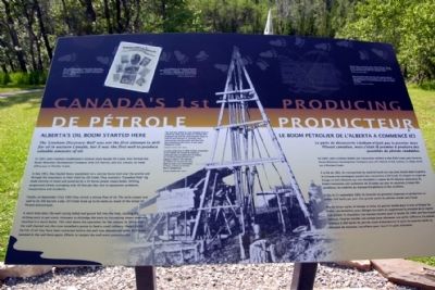
| 201 ► Alberta, Waterton Lakes National Park, Waterton — Western Canada's 1st Producing Oil Well — 1er Puits De Pétrole Producteur de L'ouest Canadien — |
| Near Akamina Parkway, 7 kilometers west of Alberta Highway 5, on the left when traveling west. | |||
| 202 ► Alberta, Waterton Lakes National Park, Waterton Park — Oil & Architecture — Pétrole et Architecture — |
| On Evergreen Avenue south of Cameron Falls Drive, on the right when traveling south. | |||
| 203 ► Alberta, Waterton Lakes National Park, Waterton Park — Waterton — |
| On Evergreen Avenue south of Cameron Falls Drive, on the right when traveling south. | |||
| 204 ► Alberta, Wetaskiwin County, Millet — Calgary and Edmonton Railway — Alberta's History — |
| On 50 Street (Provincial Highway 2A) just south of 49 Avenue, on the left when traveling south. | |||
| 205 ► Alberta, Wetaskiwin County, Wetaskiwin — Railway Station — Historic Downtown Wetaskiwin — |
| On 50 Street at 51 Avenue, on the right when traveling north on 50 Street. | |||
| 206 ► Alberta, Wetaskiwin County, Wetaskiwin — Wetaskiwin Court House/La Palais de Justice de Wetaskiwin — |
| On 50th Avenue at 47th Street, on the right when traveling east on 50th Avenue. | |||
| 207 ► Alberta, Wetaskiwin County, Wetaskiwin — Wetaskiwin Post Office — Historic Downtown Wetaskiwin — |
| On 50th Avenue just west of 50th Street, on the right when traveling west. | |||
| 208 ► Alberta, Wetaskiwin County, Wetaskiwin — Wetaskiwin Water Tower — Canada's Oldest Working Water Tower — Continually serving its community for more than 100 years — |
| On 56th Street (Provincial Highway 2A) at 50th Avenue, on the right when traveling north on 56th Street. | |||
| 209 ► Alberta, Wheatland County, Gleichen — Gleichen's Count Albert Gleichen — 1863-1937 — |
| On 5 Avenue just north of Main Street, on the right when traveling north. | |||
| 210 ► Alberta, Willow Creek District, Claresholm — Claresholm Train Station — 1911 — |
| On 1 Street West (Provincial Highway 2) at 52 Avenue West, on the right when traveling north on 1 Street West. | |||
| 211 ► Alberta, Willow Creek District, Fort Macleod — MacKenzie Bridge — |
| On 6 Avenue (Provincial Road 811) just north of 30 Street/Water Street, on the right when traveling north. | |||
| 212 ► Alberta, Willow Creek District, Fort Macleod — Territorial Court House/L’ancien palais de justice — |
| On Crowsnest Highway (Provincial Highway 3) 0.1 kilometers east of 2 Avenue, on the right when traveling east. | |||
| 213 ► Alberta, Wood Buffalo, Fort McMurray — Methye Portage — |
| On Morimoto Drive at Hardin Street, on the right when traveling south on Morimoto Drive. | |||
| 214 ► Alberta, Yellowhead County, Pocahontas — Yellowhead / Tête Jaune — Alberta's History — |
| On Yellowhead Highway (Provincial Highway 16) 16.3 kilometers west of Provincial Highway 40, on the right when traveling west. | |||
214 entries matched your criteria. Entries 201 through 214 are listed above. ⊲ Previous 100