After filtering for Scotland, 20 entries match your criteria.
Settlements & Settlers Topic
By Brandon Fletcher, June 1, 2015
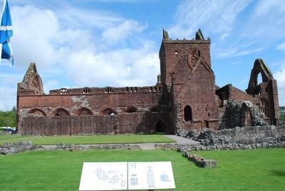
Sweetheart Abbey & Marker
| On Royal Mile close to Old Assembly Close, on the right when traveling east. |
| On Scotland Route A838, 43.4 kilometers west of Scotland Route A836, on the left when traveling west. |
| On Scotland Route A838, 45.1 kilometers west of Scotland Route A836, on the right when traveling west. |
| On Scotland Route A838, 45.1 kilometers west of Scotland Route A836, on the right when traveling west. |
| On Route A838 at Unnamed Road to Keoldale, on the right when traveling south on Route A838. |
| On Quatre Bras (Scotland Route A99) at Village Road, on the left when traveling east on Quatre Bras. |
| On Geat N Road (Scotland Route A862) at Black Isle Road, on the left when traveling south on Geat N Road. |
| On Route A99, 15.6 kilometers north of the Wick River, on the left when traveling north. |
| On Scotland Route A99, 3.2 kilometers south of of the village of John o' Groats, on the right when traveling south. |
| On Scotland Route B9011, 0.2 kilometers north of Fyrish Road, on the left when traveling north. |
| On Scotland Route A96, 0.5 kilometers north of an unnamed road, on the left when traveling east. |
| On Dundas Street at Khyber Pass, on the left when traveling south on Dundas Street. |
May. 5, 2024