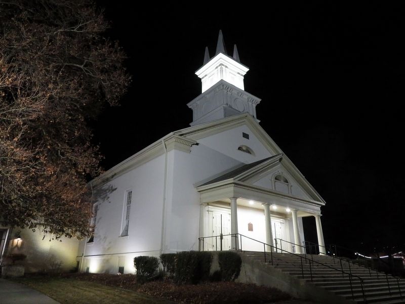
One of the oldest L.D.S. chapels. Finest at time of erection. Augustus Farnham architect. Site dedicated Feb. 11, 1857 by Elder Lorenzo Snow. Grain was stored in stone foundation when Johnston's army advanced. The walls are of adobe. Roof timbers . . . — — Map (db m192433) HM
This site was surveyed August 1, 1852 and the mill (largest of it's time in Utah) was dedicated May 6, 1853.
Built on rock foundation with solid adobe walls trimmed with red sandstone, this Burr mill operated until 1892, when roller mills . . . — — Map (db m125132) HM
Built in 1854 by John Weinel a native of Germany who came to Utah about 1853, the mill was the “overshot” water powered type & was erected on Webb’s Creek ¼ mile N.E. of this site. Native stones were used for the walls and pines for it’s . . . — — Map (db m123714) HM
Veterans Park is located between 155 West and 175 West Gentile Street on the east side of the Union Pacific Railroad tracks. The park is an irregular shaped plot, planted with grass and trees. The park is maintained by the Layton City Parks . . . — — Map (db m273231) HM WM
The Heber C. Kimball Gristmill, the foundation of which can be seen just east of this monument, was in operation from 1852 until 1892, using these burr-type gristmill stones. When the use of roller mills was introduced, mills of this type were no . . . — — Map (db m125133) HM
A 7.2-mile, earthen causeway follows a natural sand bar extending from this shore area to the northern tip of Antelope Island. It separates Farmington Bay on the south and the main body of the lake. The original road, constructed by Davis . . . — — Map (db m243430) HM
For decades after colonists settled Provo in 1849, the Utah County Court (now called the County Commission) supervised the care of those in the county who suffered from extreme poverty, mental deficiency, or mental illness. Residents of the . . . — — Map (db m223670) HM
The Kay's Ward Meetinghouse served residents of north Davis County for nearly 90 years as a center of religious and social life. Early pioneers gathered here to learn from Prophets, Apostles, and other lecturers, while plays, concerts, dances, and . . . — — Map (db m273068) HM
Homesteaders and settlers came in the 1870's to the area 4700 South to 7200 West, north to the Great Salt Lake, northeast along it's shore and the Davis County line to 4800 West and south to 4700 South. This area became Hunter Precinct in 1880 from . . . — — Map (db m35101) HM
The original, small rock home at 630 North Main Street in Farmington, Utah, is one of many stone structures that helps set Farmington apart as a city with a distinguishing architectural heritage. The home was built in 1880 by Walter Grover as a gift . . . — — Map (db m146938) HM
After sitting 161 years on its original building site, the Joseph "Cap" Hill cabin was moved to Layton Commons Park in 2017. This cabin is one of the oldest pioneer buildings in Davis County. It was built by Joseph Hill Sr. and his family between . . . — — Map (db m273214) HM
This building was originally a stage coach station built and operated in 1866 by William Reeves for the Wells Fargo Company which had control of the Overland Route. After the Utah Central R. R. was completed in 1870, it was abandoned. Mr. Reeves . . . — — Map (db m246345) HM
The first Historic District in Davis County to be listed on the National Register, the Clark Lane National Historic District encompasses the homes on State Street (formerly Clark Lane) between 200 West and 400 West. This neighborhood is significant . . . — — Map (db m225332) HM
This home began as a humble, 12-foot square, single-cell house. It was made of sun-dried adobe bricks in 1862 by John Quincy and Minion Leavitt. They soon added a second small room to the first - now the northeast corner of this house. While living . . . — — Map (db m225330) HM
John Taylor, third President of The Church of Jesus Christ of Latter-day Saints, was born 1 November 1808 in Milnthorpe, England. He joined the Church in 1836 and was ordained an Apostle two years later. He served Church missions in America, . . . — — Map (db m273066) HM
David Eccles
(1849-1912)
Western Industrialist and Utah's First Multimillionaire
A Remarkable "Rags to Riches" Journey
This statue of David Eccles bringing him to life as a hardworking boy of 14 - embodies the great hope in the . . . — — Map (db m279132) HM
In 1943, with war raging in Europe and the Pacific, hundreds of civilian workers came to Layton to work in the Defense Industry at Hill Field and the Naval Supply Depot. The united purpose of these newly hired workers was to support the war effort . . . — — Map (db m273217) HM
In memory of Captain Daniel C. Davis in whose honor Davis County was named at its formation Oct. 5, 1850.
Joined L.D.S. Church at Council Bluffs, Iowa, and enlisted in the Mormon Battalion in 1846, where he was Captain of Company E. After . . . — — Map (db m246358) HM
Centerville, also known as Deuel Creek and Cherry Creek in the early days, was first settled in 1848 by Thomas Grover and Canys and William Devel. They, along with other early settlers of Centerville, were converts to The
Church of Jesus . . . — — Map (db m246351) HM
As you survey the vast expanse of inland sea and the causeway fading off into the distance, imagine the days before the causeway existed - nearly seven miles of tangy saltwater separating you from the mainland.
Getting Underway
For . . . — — Map (db m243427) HM
Thin black lines indicate changes in relevance. Between each pair of lines entries are ordered geographically but all have the same relevance.
* Inflectional forms of words are their plurals, singulars, and possessives as well as gramatical tenses and similar variations.