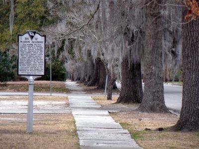
On Wilcox Avenue north of West Godbold Street, on the left when traveling north.
This building, the first public school in Marion County, was built in 1886 by the Marion Academy Society, chartered in 1811. The Society, which had operated a private school here for almost seventy-years, then turned the school over to the Marion . . . — — Map (db m25083) HM
Near North Delaware Street north of East Washington Street, on the right when traveling north.
Marion County was named for this Revolutionary General and hero, entering military service in 1775, he made an invaluable contribution to the American cause as commander of South Carolina partisans in the later years of the war. His skill and daring . . . — — Map (db m132869) HM
On Columbia Highway (U.S. 321), on the left when traveling north.
1922 Olympic Gold Medal winner Paris, France, while a student at Winthrop College. First woman in South Carolina Athletic Hall Of Fame. Outstanding educator at Columbia College. Daughter of William Asa and Lucie Ellerbe Godbold, Estill, South . . . — — Map (db m4767) HM
On Adams Street north of Monroe Street, on the left when traveling north.
Marion County was named for the Revolutionary War general, Francis Marion of South Carolina, the legendary “Swamp Fox.” It was formed in 1842 from Harrison and Monongalia Counties. The first courthouse, a two-story red brick structure, was completed . . . — — Map (db m174871) HM
Near East National Cemetery Road (State Highway S-21-13) at South Gaillard Street, on the left when traveling west.
During the Civil War, the Confederate Navy operated a large and well-guarded shipyard on the east bank of the great Pee Dee River at Mars Bluff, Marion County. The largest vessel constructed at the site was the 150 ft. wooden gunship CSS Peedee, . . . — — Map (db m149488) HM
Near Lewis Chapel Road 0.6 miles west of State Highway 43.
This site began as the family burial ground for Sofia Smith Whatley and her descendants. A South Carolina native, Whatley moved from Alabama with her son, Miles Jefferson, shortly after her husband, Martin, died in 1875. She came to this area to . . . — — Map (db m160764) HM
On County Road 225, on the right when traveling north.
Evinston Community Store and Post Office
The Evinston community store, originally a warehouse, was built of heart pine in 1884 by W.P. Shettleworth. it was bought by Joseph Wolfenden, who first operated it as a store. The post office, . . . — — Map (db m54240) HM
On North Church Street at Trinity Street, on the left when traveling north on North Church Street.
Trinity Episcopal Church is the oldest standing church in Abbeville. With its classic Gothic architecture and 125-foot steeple, it dominates the Abbeville skyline. Built by a congregation made prosperous by the economy of cotton in the antebellum . . . — — Map (db m11921) HM
On West College Street (U.S. 41) at West Main Street (U.S. 41A), on the right when traveling south on West College Street.
Grundy County
Established 1844; named in honor of
Felix Grundy
of Virginia. Chief Justice of the Kentucky Supreme Court; Rep. in Congress from Tenn. 1811-1814; U.S. Senator 1829-38. Attorney Gen. in President Van Buren's Cabinet. At the time . . . — — Map (db m150469) HM
Near Lincoln Street west of Houston Avenue, on the right when traveling west.
On the morning of April 12, 1861, South Carolina began firing on the Federal fortress in Charleston Harbor, South Carolina. Within 24 hours, Iowa and Pella became involved. When the first call came for volunteers on April 15, 1861, the citizens of . . . — — Map (db m236386) HM
On Cokesbury Road (State Highway 254), on the left when traveling east.
[Original Marker]
Site of Old Tabernacle Methodist Church. Buried here are Confederate Generals Martin Witherspoon Gary, Nathan George Evans and other Confederate officers and soldiers.
[Second Marker]
1000 feet east is . . . — — Map (db m11095) HM
On Lake Hills Lane west of Memorial Lane, on the right when traveling west.
The Zachariah O'Neal House is a rectangular single-pen log structure having corner timbering, and constructed with hewn logs. At one end there is a brick chimney. There is some weathering on the north end of the structure, but there is a new roof . . . — — Map (db m167698) HM
On Kingsburg Highway (State Highway 51) at East Trinity Road (County Road 21-909), on the left when traveling south on Kingsburg Highway.
Marion at Port’s Ferry. Port’s Ferry, 3 miles NE on the Pee Dee, was owned and operated by Frances Port (c. 1725–1812), widow of Thomas Port, who was a member of the Provincial Congress from Prince Frederick’s Parish. This was a strategic . . . — — Map (db m27932) HM
On East Main Street near Saluda Street, on the right when traveling east.
First Presbyterian Church
This church was begun in 1854 as Antioch Chapel of
Ebenezer Church under the leadership of Rev. John
G. Richards, on land of the Steeles and Workmans,
3 mi. south of Rock Hill. Mission moved in 1858 to
this site, . . . — — Map (db m11052) HM
On Military Street South (U.S. 278) at 1st Avenue SW, on the right when traveling south on Military Street South.
Side 1
February 13, 1818 — Gin Port - west of Amory, MS on Tombigbee River
December 16, 1819 — Henry Grier House, near Columbus, MS - first designated courthouse
Late 1820-1822 — Military Ford Court - under . . . — — Map (db m96791) HM
Near Stockade Drive 0.1 miles south of East National Cemetery Road, on the right when traveling south.
Florence Prison Stockade
In early September 1864, General William Tecumseh Sherman's Union army took Atlanta and came within striking range of the large Confederate prison at Andersonville, Georgia. he Confederate government responded to . . . — — Map (db m149984) HM
The First Alabama Cavalry U.S. Army
Organized July 12, 1862 - Deactivated October 20, 1865
Huntsville, Alabama
Colonel George E. Spenser, Commander
Organized by special order No. 100 by Major General Don Carlos Buell of U.S. Army. Over . . . — — Map (db m80884) HM WM
On West Main Street north of James Street, on the right when traveling north.
James W. Dillon (1826-1913), for whom the town and county are named, established a modest store in Little Rock, SC in 1853. As a cotton farmer, he understood the financial needs of his fellow citizens, which led him to provide credit for . . . — — Map (db m224324) HM
On Harllees Bridge Road (Local Road 17-23) just north of State Highway 9, on the right when traveling north.
This church was established prior to 1803 and was known as Liberty Chapel. The present structure, built in 1871, is significant both for its architecture and as a reflection of Methodism in the Pee Dee area. A Victorian adaptation of the classic . . . — — Map (db m17842) HM
On South Main Street at Presbyterian Street, on the right when traveling south on South Main Street.
(obverse)
David E.Frierson of Harmony Presbytery first preached here at Marion Courthouse in 1841. The church was organized in Feb. 1852 with six charter members: Archibald and Margaret Carmichael of Little Pee Dee Church, Rebecca E. . . . — — Map (db m121858) HM
Thin black lines indicate changes in relevance. Between each pair of lines entries are ordered geographically but all have the same relevance.
* Inflectional forms of words are their plurals, singulars, and possessives as well as gramatical tenses and similar variations.