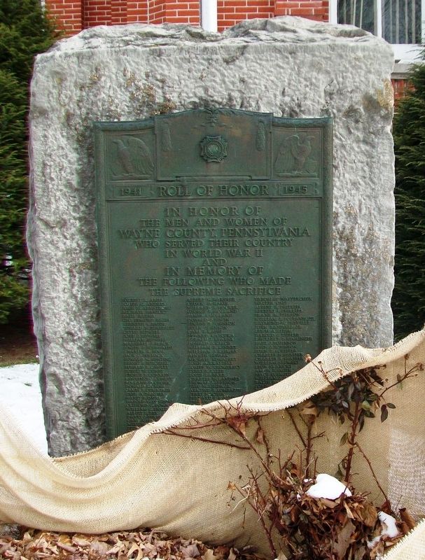
In honor of
the men and women of
Wayne County, Pennsylvania
who served their country
in World War II
and
in memory of
the following who made
the supreme sacrifice
Forrest K. Ames • Joseph G. Andres • John W. Armstrong • Michael . . . — — Map (db m101309) WM
Formed on March 21, 1798, from Northampton County. Named for Gen. Anthony Wayne. Site of test run of Stourbridge Lion, first locomotive in U.S. to run on a commercial track. Honesdale, county seat, incorporated 1831, was western terminus of D & H . . . — — Map (db m89444) HM
Barnhart Rice Homestead
The Barnhart Rice house is one of two original farmhouses occupying this 320-acre hilltop farmstead from the early days of the settlement. Started in the spring of 1822, the house was built of hand-cut sandstone . . . — — Map (db m66463) HM
Excerpts from the address delivered by General Lyman L. Lemnitzer, Army Chief of Staff, at the dedication of the Dyberry Dam on Wednesday, Aug. 19, 1959:
Today, as always, it is a very genuine pleasure to be in Wayne County and see my . . . — — Map (db m222422) HM
The Lackawaxen River is a 31.3-mile-long tributary of the Delaware River in northeastern Pennsylvania.
Lackawaxen is a Native American name. In Lenape it means "swift waters." The Lenape inhabited eastern Pennsylvania, New Jersey, Delaware, . . . — — Map (db m163628) HM
This historic building dates to the early 1800s and was built using post and beam construction. In 1821 it was owned by Russell Daniels and was called the Daniels Farm. The Delaware & Hudson Canal was built directly behind the house; Lock 31 was . . . — — Map (db m122297) HM
Erected in memory of Jirah Mumford and his descendants. He was one the first settlers in Wayne County Pennsylvania. It was also marks the place of his settlement in Belmont when he came from Connecticut on March 5, 1792 — — Map (db m89366) HM
On a clear day, September 11, 2001 America suffered surprise attacks by foreign terrorists upon her homeland. At the World Trade Center in New York, the Pentagon outside Washington, and finally in a field near a village named Shanksville in . . . — — Map (db m101307) HM WM
(Front):17th Pennsylvania Cavalry 2nd Brigade. 1st Division. Cavalry Corps. Army of the Potomac. (Back): The Regiment held this position on the morning of July 1st 1863 from 5 o'clock until the arrival of First Corps troops. The . . . — — Map (db m15383) HM WM
Dedicated to All Coal Miners
In Memoriam
Nature bestowed Pennsylvania with deposits of Anthracite coal which contains the highest percentage of fixed carbon. The coal fields approximately 600 square miles from Susquehanna and Wayne Counties . . . — — Map (db m105225) HM
On June 12, 1823, the Third General Assembly, meeting in the newly formed city of Vandalia, conveyed one and one-half acres of land to the city of Vandalia, with the proviso that the land be used as a burial ground. This is the location of that . . . — — Map (db m42428) HM
These tablets are dedicated by the Grateful Citizens of Wayne County Pennsylvania to their sons and daughters who, in a spirit of patriotism and devotion, served the United States and the Allies in the World War 1917-1918
Died in the . . . — — Map (db m116008) WM
After its heyday in the late 1850's to 1870's, the canal gradually lost business to the faster, more efficient railroads, which could ship coal in the dead of winter and the dark of night. This loss of business resulted in layoffs of boats, fewer . . . — — Map (db m142843) HM
The Lackawaxen River is a 31.3-mile-long tributary of the Delaware River in northeastern Pennsylvania.
Lackawaxen is a Native American name. In Lenape it means "swift waters." The Lenape inhabited eastern PA, New Jersey, Delaware, and . . . — — Map (db m153010) HM
1700’s
Hancock is a settlement that was once on the frontier edge of Maryland. Early maps show European settlers here in the 1730s. As an outpost on the frontier, the area known as “Tonoloway Settlement” was subject to . . . — — Map (db m96139) HM
1700’s
Hancock is a settlement that was once on the frontier edge of Maryland. Early maps show European settlers here in the 1730s. As an outpost on the frontier, the area known as “Tonoloway Settlement” was subject to . . . — — Map (db m96140) HM
Early settlers to Huron Township came from eastern states, including Massachusetts, New York and Pennsylvania. Immigration peaked in the 1830s, spurred by the sale of government land.
Among early settlers to Huron Township were William Sr. . . . — — Map (db m171691) HM
Much had been written about the Delaware & Hudson Canal but unfortunately, that is not the case for this building, especially its early years.
According to Phineas Goodrich in his 1880 book, History of Wayne County, Pennsylvania, . . . — — Map (db m122239) HM
Downtown Hawley's business section lies primarily along Main Avenue and the portion of Church Street from Main to the corner of Bishop Avenue.
The Pennsylvania Coal Company laid out the streets in this section in the 1840s and 1850s. The . . . — — Map (db m164177) HM
School
The citizens of Jeromesville have always taken a great interest in their youth and they have gone to great lengths to provide them with proper training. For many years, the chil- dren of Jeromeville attended school in . . . — — Map (db m298167) HM
The General Edgar Jadwin Dam project is part of an integrated reservoir flood risk
management system with the Prompton Lake project. Both are managed by the U.S. Army
Corps of Engineers' Philadelphia District.
Jadwin Dam is located on . . . — — Map (db m222385) HM
Tuscarora stronghold. Site of decisive battle of the Tuscarora War, March 20-23, 1713, when 950 Indians were killed or captured. Site 1 mi. N. — — Map (db m222352) HM
Fortified Indian town & site of the Tuscarora conspiracy of Sept., 1711. Capitulated, 1712, after a 10-day siege by Col. John Barnwell. Site is 4 mi. N. — — Map (db m65288) HM
Thin black lines indicate changes in relevance. Between each pair of lines entries are ordered geographically but all have the same relevance.
* Inflectional forms of words are their plurals, singulars, and possessives as well as gramatical tenses and similar variations.