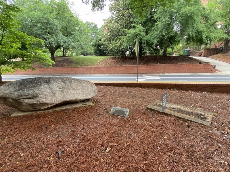
These two engraved 'petroglyphic' boulders were carved by prehistoric Native Americans of Georgia. Their exact ages are unknown but the symbols are somewhat similar to Georgia pottery designs from ca. 800 years ago. The meaning of the symbols is . . . — — Map (db m198832) HM
Mossy Creek Campground was established in 1833 and has continued as a site of yearly religious revival meetings since that time. Rock Springs Campground was established in 1887 and is one of the few remaining camp-meeting sites organized by black . . . — — Map (db m21521) HM
In 1828 gold was discovered here on Duke`s Creek, White County, by two people. John Witheroods of North Carolina found a 3-ounce nugget and a Negro servant of Major Frank Logan of Louisville, Georgia, also discovered gold on the creek. Early . . . — — Map (db m10033) HM
The Nacoochee slave cabin is one of only a few slave dwellings to survive in Georgia. Built on a stacked stone foundation and framed with hand-hewn timbers and lumber bearing the telltale marks of a sash saw, it saw for more than 150 years on the . . . — — Map (db m173152) HM
The African American Heritage Site preserves one of North Georgia’s few surviving slave dwellings and interprets the lives of black people in bondage in Appalachia before the Civil War. Framed by 19th century landscaping and displaying antebellum . . . — — Map (db m173162) HM
The largest gold nugget discovered east of the Mississippi River was found by John Phillip Thurmond on April 14, 1889 at the Hamby Mines in Northern White County. The nugget weighed 504 pennyweights and four grams, which is about 25.5 ounces. The . . . — — Map (db m131678) HM
The Atlanta Constitution ran a story entitled "Nacoochee Gems" on 4 January 1891 about the wonderful Indian artifacts recovered in the valley. It stated that the area was:
...certainly, the favored resort of a very advanced tribe of . . . — — Map (db m229246) HM
Slaves quarried and hand-chiseled this two-ton stone trough. Cool water preserved perishable foods, such as butter, cream and milk, in clay pots on the shelves of this 19th century refrigerator. Slave labor contributed to the settlement of this area . . . — — Map (db m173154) HM
This property has been placed on the National Register of Historic Places by the United States Department of the Interior October 28, 1970 — — Map (db m229382) HM
Samuel "Champ" Ferguson was the most notorious Confederate guerilla leader in the Upper Cumberland mountains. In 1861, he formed a company and began attacking Unionist partisans. Such irregular forces were common on both sides during the war, . . . — — Map (db m270278) HM
Minutes of the Inferior Court of White County, GA, August Term 1861.
Wednesday, August 7th 1861: "Ordered by the Court that White (County) Marksmen the use of any part of the courthouse that they may choose for the establishment of a military . . . — — Map (db m131679) HM
Grand Estate
This trail leads you to the Hardman Farm State Historic Site. The historic house was built in 1870 and named West End because it stood at the western border of the Nacoochee Valley. Originally this was a vast estate of more than . . . — — Map (db m291705) HM
The Distinguished Service Cross is the nation's second highest honor for valor
Rondall H. Glaze - 44 036 390, Private, Infantry, Company "A", 275th Infantry Regiment, for extraordinary heroism in action on 17 February 1945, near Lixing, . . . — — Map (db m229381) HM
Ridge and Valley
The Ridge and Valley physiographic province is an area between the Cumberland Plateau on the west and the Mountains on the east. This 9,000 square mile great valley extends diagonally across east Tennessee from Virginia to . . . — — Map (db m206495) HM
Thin black lines indicate changes in relevance. Between each pair of lines entries are ordered geographically but all have the same relevance.
* Inflectional forms of words are their plurals, singulars, and possessives as well as gramatical tenses and similar variations.