19 entries match your criteria.
Historical Markers and War Memorials in New Zealand
By Erik Christeson
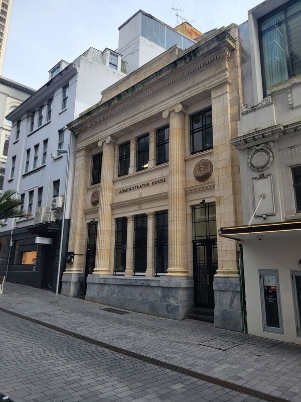
Administrator House Marker
| 1 ► New Zealand, Auckland, Central Business District — Administrator House — (Alliance Insurance Building) — |
| On O'Connell Street, on the right when traveling south. | |||
| 2 ► New Zealand, Auckland, Central Business District — Ferry Building — |
| On Quay Street, on the right when traveling west. | |||
| 3 ► New Zealand, Auckland, Central Business District — General Building — (Yorkshire House) — |
| On Shortland close to O'Connell, on the left when traveling west. | |||
| 4 ► New Zealand, Auckland, Central Business District — Lord Freyberg Statue — |
| On Freyberg Place. | |||
| 5 ► New Zealand, Auckland, Central Business District — Police Station & Court — |
| On O'Connell Street at Chancery, on the left when traveling north on O'Connell Street. | |||
| 6 ► New Zealand, Auckland, Central Business District — South African War Memorial — |
| Near Princes Street. | |||
| 7 ► New Zealand, Auckland, Central Business District — The Dilworth Building — Auckland City Council Schedule ‘B’ — |
| On Queen Street close to Customs Street E, on the left when traveling south. | |||
| 8 ► New Zealand, Auckland, Viaduct Harbour — The Ubiquitous Scow — "Auckland was built on the scow." - Anon — |
| On Customs Street West, on the right when traveling west. | |||
| 9 ► New Zealand, Manawatu-Wanganui, Rangitikei District, Taihape — Taihape Clock Tower — |
| On Huia Street at Hautapu Street, on the left when traveling east on Huia Street. | |||
| 10 ► New Zealand, Otago, Queenstown-Lakes District, Arrowtown — Invited but Unwelcome — The harsh reality of goldfield life — |
| Near Buckingham Street north of Villiers Street, on the left when traveling north. | |||
| 11 ► New Zealand, Otago, Queenstown-Lakes District, Arrowtown — Welcome to the Arrowtown Chinese Settlement — and the story of a remarkable people — |
| Near Buckingham Street north of Villiers Street, on the left when traveling north. | |||
| 12 ► New Zealand, Southland, Southland District, The Key — Te Wahipounamu — South West New Zealand World Heritage Area — A natural treasure of world significance — |
| Near Te Anau-Mossburn Highway (State Highway 94) 0.5 kilometers west of Lagoon Creek Road, on the left when traveling west. | |||
| 13 ► New Zealand, Wellington, Wellington Council, Wellington, Wellington Central — Hikitia Floating Crane — |
| On Commonwealth Walkway at Great Harbour Way, on the right when traveling north on Commonwealth Walkway. | |||
| 14 ► New Zealand, West Coast, Buller District, Cape Foulwind — Guiding Light — |
| On Cape Foulwind Walkway, 0.3 kilometers west of Lighthouse Road. | |||
| 15 ► New Zealand, West Coast, Buller District, Karamea — The History of the Karamea Estuary — |
| On Ray Street, 0.5 kilometers west of Wharf Road. | |||
| 16 ► New Zealand, West Coast, Westland District, Ōkārito — Frontier Building … Legendary Man — |
| On The Strand, on the right when traveling north. | |||
| 17 ► New Zealand, West Coast, Westland District, Franz Josef / Waiau — Peter's Pool — Reflections of the past — |
| 18 ► New Zealand, West Coast, Westland District, Haast — Welcome to Ship Creek — Nau mai, haere mai, tauti mai ki Tauparikaka — |
| Near Haast Highway (West Coast Route 6), on the left when traveling north. | |||
| 19 ► New Zealand, West Coast, Westland District, Jackson Bay — Jackson's Bay — |
| On Haast-Jackson Bay Road at Pier Street, on the left when traveling south on Haast-Jackson Bay Road. | |||