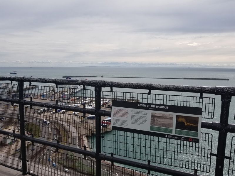
A View of the Harbour
Below you is Admiralty Harbour, the naval and merchant port that made Dover so important in the First and Second World Wars. There has been a harbour here since Roman times: this one was built in stages between 1847 and 1909 . . . — — Map (db m128521) HM
A View to the East
This view along the coast reveals the towering height of the famous White Cliffs, elements of Dover's past defences and its ever-changing port.
On the distant hill, a tall mast occupies the site of Langdon Battery, where . . . — — Map (db m128520) HM
A View to the West
This view looks down into the ancient heart of Dover.
The Romans built two forts and a settlement, known as Portus Dubris. These were succeeded by a thriving Saxon and a later medieval walled town, all nestled in the . . . — — Map (db m128522) HM
Admiral Sir Bertram Ramsay
KCB KBE (1883-1945)
This statue commemorates Admiral Sir Bertram Home Ramsay, the inspirational commander of the naval forces during the Dunkirk evacuation in 1940 and D-Day in 1944. He served in the tunnels below Dover . . . — — Map (db m128560) HM
In Memory Of
Admiral Sir Bertram Ramsay
KCB KBE MVO 1883 — 1945
Vice Admiral Dover 1939 – 42
C-inC Allied Naval Expeditionary Force
June 1944 and of those who died in the
Dunkirk and Normandy operations
( back )
I . . . — — Map (db m128561) HM
St Mary-in-Castro church was built around AD 1000, before the Norman Conquest.
The pharos is a Roman lighthouse and the oldest building in the castle.
The Duke of Suffolk’s Lodgings, a castle building modified for the Duke of Buckingham in . . . — — Map (db m128503) HM
Command, Control and Communication
This building began in 1874 as a gun battery to defend Dover from attack by enemy ships. Beginning in 1891, the battery was decommissioned and the structure adapted so that, by the First World War, it fulfilled . . . — — Map (db m128518) HM
Dover's defences
A mighty fortress
There was a castle here shortly after the time of the Norman Conquest in 1066. The medieval defences visible today were built in three periods between 1179 and 1256. They evolved over the next 700 years, . . . — — Map (db m128505) HM
Dover’s early history
Long before the castle
People occupied this hill over 2,000 years ago and as much as 1,200 years before Dover Castle was first built. the huge earthworks of the castle outer bailey probably began as the ramparts of an . . . — — Map (db m128500) HM
Fighting the Enemy in the Sky
The First World War brought a new threat of destruction to home shores from airships and aircraft, invented just a few years earlier and recently armed. This was a terrifying development that needed a quick response, . . . — — Map (db m128515) HM
Finding the Enemy
This tiny structure, a Position-Finding (PF) Cell, performed a major role in the period 1891-1918. It was used to pinpoint the position of enemy ships and to relay that information to the coast defence guns at Langdon Battery, 1km . . . — — Map (db m128516) HM
Auguste Louis Blériot
(b.July 1, Cambrai, France 1872; d.August 2, 1936), graduated from École Centrale Paris with a degree in engineering.
At 30 he taught himself to fly in an aircraft of his own design, his skills as a pilot and designer . . . — — Map (db m128568) HM
( west side )
Historic Dover
Market Square
A fair or market has been held in the Square since at least 1160, the most important being the annual St. Martin's Fair. Dover's Guildhall was built in the centre of the Square in 1605 on . . . — — Map (db m168140) HM
Medieval Dover
The heart of the medieval castle
The inner bailey of the castle was built for King Henry II by his engineer, Maurice, largely between 1179 and 1199. It contained the Great Tower, which formed the ceremonial, defensive and . . . — — Map (db m128504) HM
In
Memory Of
The Rescue Of Allied Forces
From Dunkirk, May - June 1940
To The Rescuers
Whose Courage Made It Possible
And To The Rescued
Who Lived To Fight Again
May 2015 — — Map (db m128559) WM
Side A
During 1941, the German Battle Cruiser SCHARNHORST operated unchallenged in the Atlantic resulting in the sinking of 115,622 tons of British Merchant Shipping. Requiring maintenance it went to Brest harbour where it was joined by its . . . — — Map (db m132492) HM
Ramsay: retreat and return
Operation Dynamo 1940
The German attack into western Europe in May 1940 led to the allied armies rapidly retreating. By late May, the British Expeditionary Force and parts of the French and Belgian armies were trapped . . . — — Map (db m128558) HM WM
Saluting Platform
Beneath here is the Long Gun Magazine,
a gunpowder magazine of c1800. This was
buried in the 1930s to form this
parade ground and saluting platform. — — Map (db m128562) HM
St. Mary’s Church and Cannon Street
Historic Dover
The Church of St. Mary the Virgin has been one of Dover's main parish churches for over 400 years. The building is of early Norman origin, and Norman architecture can still be seen in the lower . . . — — Map (db m128567) HM
The Signal Platform
Below you, the roof of the Port War Signal Station (PWSS) formed a signalling platform during the First World War. It was replaced in the Second World War by the roof you are standing on.
Signallers on the roof sent messages . . . — — Map (db m128519) HM