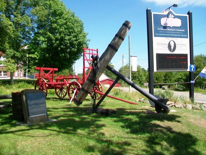
This 18th century anchor
retrieved from the
Petitcodiac River
at Hopewell Cape in 1981
by Jack Weldon
Donated to the
Albert County Historical Society
by
his wife Grace
and sons James, Thomas and Dale
This plaque was given as a . . . — — Map (db m106638) HM
(English:) Captured World War I German 77mm field gun manufactured by Krupp Armaments in Germany and introduced in 1896. Model: C96n/A Calibre: 77mm Maximum Range: 9186 yards (5 Miles) Weight: 1930 lbs. (8 75kg) Rate of Fire: 10 . . . — — Map (db m138994) HM WM
Although visitors had been coming to the island since 1855, Campobello's summer trade did not really prosper until the 1880s - years of long summer vacations and great resorts. A group of Boston and New York businessmen bought most of the . . . — — Map (db m63639) HM
Friar's Head takes its name from the stone pillar or stack (photo 1) that rises from the beach directly below the observation deck. While occupying Eastport, the British navy was said to have used the stone pillar for target practice, . . . — — Map (db m63629) HM
[English version]
Built in 1885, the Mulholland Point Lighthouse guided many small coasters and freighters taking the shorter and foul weather-protected route through the narrow passage between Campobello and Lubec. Steamships, carrying freight . . . — — Map (db m54894) HM
Built in 1885, the Mulholland Point Lighthouse (photo 1) served as a guide for the many small coasters and freighters taking the shorter and more foul weather-protected route through the Lubec Narrows. Steamships, such as the . . . — — Map (db m63593) HM
Two of the Campobello Company's founders, Alex S. Porter and Samuel Wells, and several of the luxury hotel visitors, including James Roosevelt and families by the name of Sturgis, Cochrane, Prince, and Pell purchased land and refurbished or . . . — — Map (db m63641) HM
During the years FDR summered on Campobello, the daughter of one of Campobello's summer colonists married Dexter P. Cooper, an eminent American engineer. Cooper studied the tremendous rise and fall of Passamaquoddy Bay's tides and became . . . — — Map (db m63611) HM
Ce canon a été en service dans les jungles de Burma, tout près de l'Australie et l'Afrique du Nord. Il termina son service en 1996 pour retourner au Canada, par la suite fut donné à la localité de Kedgwick en l'honneur de tout les . . . — — Map (db m125694) HM WM
La croix et le coq sont au sommet de la plus haute structure de la Ville de Saint-Quentin. Le coq et la croix du clocher de l'église du Très Saint-Sacrement proviennent de l'église précédente détruite par le feu au soir du 10 . . . — — Map (db m125680) HM
La fontaine fut érigée en 1957 en l'honneur des fondateurs de Saint-Quentin, elle est un don de M. Patrick Jean, entrepreneur prolifique de la paroisse. Elle fut construite par. M. Andréas Coulombe.
Le dévoilement du monument . . . — — Map (db m125684) HM
English: This historic streetscape is distinguished by its rare concentration of homogeneous, primarily late 19th century architecture. Traditionally referred to as “Wall Street,” the area contains major public buildings, banks, . . . — — Map (db m137519) HM
English:
In 1822 when Robert Foulis arrived in Saint John, New Brunswick he was 30 years old, a well-educated Scotsman from Glasgow, recognized as brilliant in sciences, and trained as an engineer. He spent the rest of his life in . . . — — Map (db m141998) HM
English:
Born in Maine in 1810, young Kilby Reynolds soon proved he had remarkable mechanical skills. His inventive mind enjoyed developing improvements and trying new ideas.
In 1844 Reynolds purchased a large sawmill property . . . — — Map (db m142001) HM
English: From its origins in the late 18th century, the shipbuilding industry profoundly influenced New Brunswick history. Craftsmen in the colony built over 6,000 vessels during the 19th century, a third of the total tonnage produced in . . . — — Map (db m137643) HM
During the spring freshet, 6000 m3 or six million litres of water, 9/10ths the volume of Niagara Falls, cascades over the falls every second. A few months later, virtually all the water is diverted to the power plant. . . . — — Map (db m125521) HM
The stone towers supported the cables of the 1860 bridge. The cement pier bore the spans of the 1914 steel structure. The present bridge (1976) is named for jockey Ron Turcotte. It is 83.5 m long and 42.4 m above the river. . . . — — Map (db m125518) HM
In honored memory of
the men of
Grand Falls who
laid down their lives
in the Great War
1914 ——— 1918
Their names
liveth forever
[Honored Dead]
Paul E. Green • John A. Taylor • T. H. Pirie • R. A. Estey
Reed West . . . — — Map (db m125314) WM
A pump-house was constructed on this site in the fall of 1919 to house a large water pump driven by a 40HP electric motor. The pump was installed to boost the water pressure in the Town’s hydrants during times when water was required for fire . . . — — Map (db m106382) HM
The rectory was constructed in the Queen Anne Revival style in 1880 on land given by J.F. Allison and Mary Allison Botsford. The design was prepared by R. C. Boxall and constructed by Mr. J. Teed of Dorchester. Great pains were taken with the . . . — — Map (db m106390) HM
Erected by
the Town of Sackville
to commemorate
the designer
of the Canadian flag
George F. G. Stanley
C.C., C.D., K.StJ., D.Phil., LL.D.
Former Lieutenant-Governor of
New Brunswick, Professor, Historian,
Second World War . . . — — Map (db m106430) HM
The construction of St. Paul's began in 1856, based on a model brought by the Rt. Rev. John Medley, First Bishop of Fredericton. Bishop Medley's interest in Gothic Revival architecture, recreating a medieval stone building in New Brunswick wood, . . . — — Map (db m106421) HM
The Royal Canadian Air Force has stood on guard for Canada since 1924. Over three hundred and twenty five Sackville area residents and students of Mount Allison University have served in the R.C.A.F. both here and abroad from the First World War . . . — — Map (db m106550) HM
English:
This building is one of four remaining structures of the British establishment which housed the garrison at Fredericton from 1784 until the withdrawal of Imperial troops in 1869. Occupying the area between York and Regent . . . — — Map (db m139996) HM