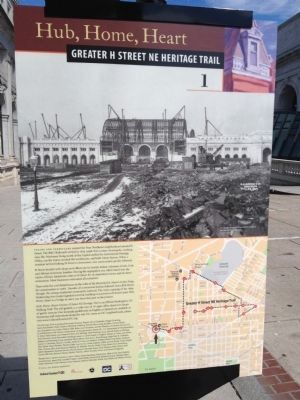
Union Station, across First Street, was the world’s largest railroad terminal when it opened in 1907. Its construction took five years and displaced hundreds of small houses and businesses. Architect Daniel Burnham’s Beaux-Arts masterpiece, . . . — — Map (db m71678) HM
With its view of the Capitol and Senate office buildings, and with the Library of Congress and the Supreme Court just a short stroll away, Union Station truly is the gateway to the heart of the nation's government. The station is also where . . . — — Map (db m71679) HM
This is the western edge of what once was the rough, working-class Swampoodle neighborhood. In the early days the marshy Tiber Creek ran between what are now North Capitol and First Streets, NE. Legend has it that lingering rain puddles ("poodles") . . . — — Map (db m59928) HM
Stuart-Hobson Middle School, one block to the east of this sign, was built in 1927 on the site of an old brewery, one of nearly two dozen that operated in DC after the Civil War. Almost all of the breweries were run by German immigrants who . . . — — Map (db m71681) HM
The elegant Romanesque portion of the Senate Square condominium complex started life in 1874 as the Little Sisters of the Poor House for the Aged. St. Aloysius Church member Ellen Sherman, wife of Civil War General William Tecumseh Sherman, . . . — — Map (db m186806) HM
Uline Arena was built in 1941 by ice maker Mike Uline to present ice skating, hocky, basketball, and tennis. The Dutch immigrant, originally named Migiel Uihlein, had made a fortune patenting ice production equipment and selling ice from his . . . — — Map (db m71683) HM
This high ground near the B&O Railroad tracks has been Union Terminal Market since 1931. That year Center Market on Pennsylvania Avenue, NW, came down to make way for the National Archives. Vendors seeking new locations clustered here. . . . — — Map (db m71684) HM
Gallaudet University is world renowned as the premier institution for higher education for deaf and hard of hearing students. It opened as the Columbia Institution for the Instruction of the Deaf and Dumb and Blind in 1856 on land donated by . . . — — Map (db m71685) HM
The Trinidad neighborhood, named for W.W. Corcoran's original estate, got its start in the 1890s after the Washington Brick Machine Company used up the clay here making bricks. With H Street filling in with houses and businesses, the company . . . — — Map (db m186807) HM
When the Atlas Performing Arts Center opened in 2005, it gave hope to an area still recovering from the destruction following the assassination of the Reverend Dr. Martin Luther King, Jr., in 1968. But when K-B's Atlas movie house opened here . . . — — Map (db m152470) HM
The starburst intersection of five major roads marks this spot as a transportation hub for the neighborhood and the region. Shortly after Congress arrived in Washington in 1800, city leaders chose an old farm road to create a private toll . . . — — Map (db m71688) HM
Maryland Avenue in the 1930s was home to immigrants from around the Mediterranean. Evelyn Kogok Hier grew up at 1328 Maryland Avenue. She remembered her next-door neighbor, the Right Reverend Ayoub (Job) Salloom, hosting after-church gatherings . . . — — Map (db m152471) HM
The small scale and low rents of H Street's oldest buildings have lured waves of immigrant entrepreneurs since the buildings were new in the 1880s. By 1930, alongside Greek, Italian, Irish, and other immigrant-owned shops, at least 75 . . . — — Map (db m71690) HM
The handsome church on this corner is the second to occupy this spot. The first was a small brick chapel built by John A. Douglas in 1878 for the new Memorial Methodist Episcopal Church. Soon after, it was renamed Douglas Memorial Methodist . . . — — Map (db m71691) HM
One year before Congress and the President arrived in their new capital city in 1800, Washington's Navy Yard opened at the foot of Eighth Street, two miles south of this sign. The yard soon became the city's biggest employer. In 1908 streetcars . . . — — Map (db m60097) HM
On Friday, April 5, 1968 the 600 block of H Street went up in flames. The Reverend Dr. Martin Luther King, Jr., had been assassinated a day earlier, and grief-stricken, angry men and women had taken to the streets across the city. Some took . . . — — Map (db m71692) HM
Ourisman Chevrolet once occupied almost the entire north side of this block. After two years as a top-performing Chevy salesman on Connecticut Avenue, and with a $2,000 loan from his widowed mother, Benjamin Ourisman opened his own dealership . . . — — Map (db m71693) HM
Calvary Episcopal Church, half a block north at 820 Sixth Street, has been a community anchor since 1901. For most of its early years, the congregation, led by founding rector Reverend Franklin I.A. Bennett, met at 11th and G. In 1941 it . . . — — Map (db m152487) HM