On Kalamazoo Street at Phoenix Street, on the right when traveling south on Kalamazoo Street.
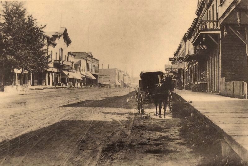
When South Haven became an incorporated town in 1869, it was a tiny but prosperous village with a bustling economy. Lake Michigan provided robust fishing, lumbering, shipping and fruit industries and the downtown business district grew quickly. . . . — — Map (db m119254) HM
On Dyckman Avenue east of Black River Street, on the right when traveling east.
Today, crossing the Black River is a far simpler task than in the past. Early travelers relied on ferryboats to transport them across the river until 1856, when a wooden drawbridge was constructed.
From 1889 until 1968, an iron swing bridge . . . — — Map (db m119255) HM
On Water Street, 0.1 miles west of Kalamazoo Street, on the right when traveling west.
South Haven emerged as a commercial shipping center in the 1850s. By the late nineteenth century, lumber, fruit, and other manufactured goods were transported between South Haven, Chicago, and other cities on steam vessels. Commercial shipping . . . — — Map (db m119257) HM
On Water Street at St. Joseph Street, on the right when traveling west on Water Street.
The South Haven Lightkeeper's dwelling was built by the United States Lighthouse Service in 1871-1872, when South Haven's first lighthouse was constructed.
The dwelling was last occupied by a lightkeeper in 1940, when technical changes . . . — — Map (db m119258) HM
Near Water Street, 0.1 miles west of St. Joseph Street, on the right when traveling west.
In 1861, the first piers appeared on the north and south side of the entrance to the Black River. The channel between the piers was dredged to allow access to larger ships. In 1867, the piers were extended and the channel was widened which . . . — — Map (db m119260) HM
Near Water Street, 0.1 miles west of St. Joseph Street, on the right when traveling west.
The City of South Haven took a major step forward in providing utility services to residents in 1892 when a water pumping station was constructed on the lakeshore. In 1895, the City purchased its first electric generator. The original water pumping . . . — — Map (db m119261) HM
Near Water Street west of St. Joseph Street, on the right when traveling west.
The Lifesaving Station was a prominent landmark on South Haven's waterfront for more than a century before it was destroyed by fire in 1989. The U.S. Lifesaving Service (USLSS) built the lifesaving station in 1887 to ensure the safety of ships, . . . — — Map (db m119262) HM
Near Water Street, 0.1 miles west of St. Joseph Street, on the right when traveling west.
The first light was erected in 1872 at the end of a 225 foot wooden pier that had been in use since 1861. The square pyramid wooden structure consisted of two rooms mounted on a raised platform. The bottom room was for oil storage, the top room . . . — — Map (db m119263) HM
On Black River Street, 0.1 miles south of Dyckman Avenue, on the left when traveling south.
Commercial fishing was part of South Haven's diverse maritime economy from the 1860s until the 1970s. In 1932, Christopher Jensen, a Danish immigrant, opened a commercial fishery on the Black River near the Dyckman Avenue Bridge.
The Jensen . . . — — Map (db m119266) HM
On Black River Street, 0.1 miles south of Dyckman Avenue, on the right when traveling south.
By: Chief Pokagon
"Our traditional account of South Haven given us by ki-os-ag (our forefathers) was held as sacred by them as Holy Writ by the white man. Long, long bi-bong (years) ago Ki-ji Man-i-to (the Great Spirit) who held dominion of . . . — — Map (db m119267) HM
On Black River Street, 0.2 miles south of Dyckman Avenue, on the left when traveling south.
Between 1866 and 1902, more than 50 wooden ships were built at shipyards along the banks of the Black River. The construction of these ships was financed by the ship owners, local merchants, groups of shareholders, and small shipping companies. . . . — — Map (db m119268) HM
On Black River Street, 0.3 miles south of Dyckman Avenue, on the left when traveling south.
As the City of South Haven's population grew, and with the arrival of steamship and train passengers, a greater need for entertainment became realized. The popular pastime of the day was "bathing" - referred to as "swimming" today - in Lake . . . — — Map (db m119279) HM
On Lakeshore Drive, 0.1 miles west of North Shore Drive, on the right when traveling east.
For over a century, South Haven's beaches, fishing, and boating have attracted tourists. By 1880, steamship lines and railroads brought thousands of visitors from Chicago, Grand Rapids and Kalamazoo. Resort hotels, guesthouses, cottages, and . . . — — Map (db m119280) HM