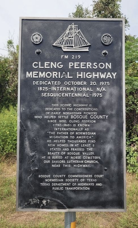
On Farm to Market Road 219 at Farm to Market Road 182, on the left when traveling east on Road 219.
Though never as numerous as some national groups emigrating from Europe, Norwegians left an imprint on rural life in Texas.
Hundreds sailed to the United States beginning in the 1830's. For those who settled in Texas, Bosque County had great . . . — — Map (db m283688) HM
On County Highway 2650 0.8 miles north of Farm to Market Road 927, on the left when traveling north.
This cemetery was originally known as the Morgan Cemetery due to its location on land owned by Daniel Morgan (1818-1892), a native of Kentucky. Morgan came to Texas from Illinois with his family in 1834. Morgan served in the Civil War in Company F, . . . — — Map (db m194300) HM
On U.S. 180 at RD Bell Road, on the left when traveling east on U.S. 180.
Created Aug. 27, 1856, from Navarro and Bosque counties; organized in 1857. Spanish name Palo Pinto refers to Spotted Oak, a common regional tree having bark with a mottled appearance.
Good hunting and abundant water made area a favored . . . — — Map (db m260146) HM
On Meridian Street at 1st Street, on the right when traveling west on Meridian Street.
Following the settlement of Norwegian immigrants in Bosque County in 1854, Lutheranism became the predominant denomination in the region. In 1886, St. Olaf Kirke, named after the Patron Saint of Norway, was built to address the worshiping practices . . . — — Map (db m283675) HM
By the mid-1850s, F.F. Bloodworth had built a log cabin in the early Valley Mills settlement which served as a school, community meeting place, and the Liberty Hill Baptist Church. In 1855, that congregation had ten charter members but grew to 38 . . . — — Map (db m233702) HM
On Farm to Market Road 182 south of County Road 4195, on the left when traveling north.
The first Norwegian immigrants to Bosque County arrived in 1854. As the number of Norwegian settlers increased after the end of the Civil War, most families continued the rural farming traditions practiced in their homeland. The commercial and . . . — — Map (db m283683) HM
On County Road 4145 at Farm to Market Road 182, on the right when traveling north on County Road 4145.
Mother church former Evangelical Lutheran Church in Texas. Organized June 14, 1869 by Norwegian settlers of Bosque County. Building erected 1875-1885.
Cleng Peerson, pioneer of Norwegian emigration to U.S. (Landed 1821) is buried here. . . . — — Map (db m283678) HM
On South Bosque Street (State Road 22) 0.1 miles north of Farm to Market Road 933, on the left when traveling south.
The construction of Whitney Dam caused the creation of this cemetery in 1950 for the reinterment of 1260 graves from six historic cemeteries in Hill and Bosque Counties. Before Lake Whitney inundated several pioneer cemeteries, all of the gravesites . . . — — Map (db m264593) HM
Near University Parks Drive east of Washington Avenue, on the left when traveling east.
Born to a Jewish family in Spanishtown, Jamaica, British West Indies, Jacob de Cordova immigrated to Philadelphia about 1830. After a brief return to Jamaica where he founded a newspaper, he became engaged in trade between New Orleans and Texas. He . . . — — Map (db m94685) HM
Site of Emigrant Trail, the Frontier Military Road, and Fort Phantom Hill, founded in 1851 to guard the military road.
County created 1858 from Bexar and Bosque counties. Named for Anson Jones (1798–1858), a veteran of San Jacinto, . . . — — Map (db m78965) HM
On Farm to Market Road 219 at County Road 4230, on the left when traveling west on Road 219.
Called the "Father of Norwegian Immigration to America", Cleng Peerson migrated to the United States from his native Norway in 1821. He traveled extensively and encouraged his countrymen to settle on land he selected in the east and midwest. Coming . . . — — Map (db m283689) HM
On Bosque County Road at County Highway 3112, on the right when traveling east on Bosque County Road.
Built in 1884 by the Wrought Iron Bridge Company of Canton, Ohio, at a cost of $6,465, this bridge spans 150 feet across the north Bosque River. This type of bridge, called a Whipple Truss, was named for its designer. One of the few remaining . . . — — Map (db m233815) HM
On State Highway 22 at State Highway 6, on the right when traveling east on State Highway 22.
Named for the Bosque (Spanish for "Woods") River. The territory now part of this county was traversed in 1841 by the Texan-Santa Fe Expedition. Maj. George B. Erath, noted surveyor and soldier, explored the region prior to its settlement. The . . . — — Map (db m240399) HM
Ole Knudson was born in 1832 to Knud and Anna Knudson in Nordstokke on Norway's Karmøy Island. In 1850, the family, changing their name to Canuteson, moved to Illinois, where Ole wed Ellen Maline Gunderson, also of Nordstokke. At the urging of . . . — — Map (db m178229) HM
On Windsor Road south of Enfield Road, on the right when traveling south.
Born in Bosque County of a noted pioneer family. A legislator (1909-13); first Assistant Attorney General (1913-18); Attorney General (1918-21). As Chief Justice (1921-40) Texas Supreme Court, recorded longest service in court’s first century. . . . — — Map (db m149748) HM
Near Pecan Street 0.1 miles south of Honeysuckle, on the right when traveling south.
George Lafayette Ramsdale (1820-1884) was a native of Devonshire, England. By 1836, he had come to Texas and enlisted in the Army during the War for Independence from Mexico. After the Revolution, Ramsdale, his wife, Elizabeth (1825-1909), and . . . — — Map (db m146880) HM
On South Micheaux Street, on the right when traveling north.
As a coach of athletics and a youth mentor, Robert (Bob) Knight positively influenced the lives of countless Palestine citizens. He was born in Iredell (Bosque County) in 1909, the last of eight children of William and Missouri Jane (Hand) Knight. . . . — — Map (db m128977) HM
Tennessee native Roden Taylor Crain, a member of Capt. William Kimbro's company of San Augustine County volunteers, was a soldier in the struggle for Texas Independence from Mexico. He fought at the Battle of San Jacinto on April 21, 1836, and later . . . — — Map (db m233706) HM
On Walnut Avenue at 3rd Street (Farm to Market Road 927), on the left when traveling east on Walnut Avenue.
Indian fighter, lawman and rancher. Settled on the Palo Pinto County frontier, 1854. Led neighbors in defending homes during Indian raids.
In 1860 helped rescue Cynthia Ann Parker, who had been taken 24 years before by Comanches.
Captain . . . — — Map (db m194301) HM
Near North Mechanic Street just north of West Day Spring Lane, on the left when traveling north.
Overview The Homestead Act of 1862 made government land taken from Native Americans available for free if it was used for five years. This law allowed millions of European immigrants to settle in the prairies and woodlands of the central . . . — — Map (db m236673) HM
On Farm to Market Road 56 0.1 miles north of County Road 3356, on the right when traveling south.
Located near Childress Creek, the Cayote community grew around a grocery store, later known as Cayote Store, established about 1866. The store supplied settlers and drovers herding cattle to markets. In 1879, the store applied for a post office . . . — — Map (db m264605) HM
On Farm to Market Road 2114 at County Highway 1304, on the left when traveling west on Highway 2114.
Spivey Crossing is a farming community located along the Brazos River Valley. Established as early as 1854, Spivey Crossing was an old wagon trail crossing named for Temple Spivey, the first known settler of the Smith Bend community of Bosque . . . — — Map (db m161715) HM
On Farm to Market Road 56 0.2 miles east of County Highway 2490, on the left when traveling west.
The Coon Creek community evolved from the Old Cyrus community, the oldest settlement in southeastern Bosque County. The first settler was Temple Spivey who purchased land on the Brazos River in 1853. In January 1856, John Jackson Smith purchased . . . — — Map (db m161798) HM
On South Avenue Q at West 9th Street, on the left when traveling north on South Avenue Q.
Joseph Olson left Norway with his family-wife Anna Karina, daughter, Anna Marie 8 years, sons Ole Mikkel 6 years, Jacob 4 years, and Torborg 1 year, in May of 1858. They traveled to America, landing first in Quebec, Canada after 7 weeks at sea. . . . — — Map (db m233724) HM
On N. Minter Avenue (U.S. 283) at Texas Highway 79, on the right when traveling north on N. Minter Avenue.
Formed from Rannin and Bosque Counties
Created January 13, 1858
Organized March 18, 1879
Named in honor of
Dr. William Edward Throckmorton
1795 - 1843
A Revolutionary soldier
Father of James Webb Throckmorton,
who became . . . — — Map (db m93349) HM
Thin black lines indicate changes in relevance. Between each pair of lines entries are ordered geographically but all have the same relevance.
* Inflectional forms of words are their plurals, singulars, and possessives as well as gramatical tenses and similar variations.