On North Main Street at East Poplar Avenue (Tennessee Route 57), on the right when traveling north on North Main Street.
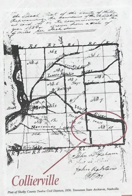
The Original Town Site of Collierville/Colliersville
In this area and to the east, lies the original town site of Collierville. The lands that were destined to become Collierville traveled through many periods of history before a village . . . — — Map (db m149071) HM
For African Americans in the 1960s, being kicked off white-owned lands for trying to register to vote no isolated incident. Just as had happened here in Lowndes County, blacks in Tennessee, Mississippi, and Greene County, Alabama, were driven from . . . — — Map (db m112389) HM
On Chester Street north of Walker Street, on the left when traveling north.
The land currently known as Arlington originally belonged to the Chickasaw Indians. In 1818, a Treaty with the Chickasaw ceded this land, along with other land in West Tennessee, to the United States. On November 24, 1819, Shelby County was . . . — — Map (db m179116) HM
On Walnut Street (U.S. 90), on the right when traveling east.
William L. Menefee, born ca. 1796 in Knox County, Tennessee, served in the Tennessee Militia in the War of 1812. He studied law and was admitted to the bar sometime prior to 1824 when he moved to Alabama. In 1830 he and his wife Agnes (Sutherland) . . . — — Map (db m130391) HM
On Plum Grove Cemetery Road 0.4 miles north of West Point Loop, on the left when traveling north.
Old Plum Grove Cemetery began as a family burial ground. Texas pioneer John Y. Criswell buried his wife, Eleanor, on this site. The Criswell family was part of Stephen F. Austin's third colony, which arrived in Texas by 1830. In 1839, the Plum Grove . . . — — Map (db m195931) HM
Near Farm to Market Road 153 0.1 miles west of North Raymond Road, on the right when traveling west.
Originally known as Winchester Colored Cemetery, Shiloh Cemetery has served the black community of Winchester and its vicinity since they bought it in 1890 during the town's boom period. Its 3.6 acres abuts the east boundary of the Winchester Public . . . — — Map (db m220182) HM
On Farm to Market Road 153 at North Raymond Road, on the right when traveling west on Highway 153.
Shiloh was one of many communities of displaced, newly-freed slaves that sprang up after the Civil War. Named from the bible, it was located outside Winchester, near what became known as the Shiloh Branch of the Colorado River. Shiloh Missionary . . . — — Map (db m220159) HM
Near Farm to Market Road 153 0.1 miles west of North Raymond Road, on the right when traveling west.
In use as burial ground since site gift in 1871 by Col. Nathan Thomas (1809-81), former Republic of Texas congressman, member of the legislature, civic leader.
Many Ingram Prairie pioneer families are interred here. Cemetery association was . . . — — Map (db m220188) HM
On Chester Street just north of Forrest Street, in the median.
The Harrell Farm Log Cabin is estimated to date back to the mid-1800's and served as the cook's residence at the Harrell Farm. The Harrell farm was located along Harrell Road, in both Shelby and Fayette Counties, and the log cabin was located near . . . — — Map (db m85812) HM
On Interstate 69E Frontage Road 0.7 miles south of County Road 34, on the right.
Martha Reagan moved with her parents from Tennessee to Fayette County, Texas where she met and married John Rabb (1825-1872). In 1857, John and Martha moved their family to Nueces County and settled near Banquete, where John pursued cattle ranching . . . — — Map (db m270058) HM
On Church Street (Tennessee Route 194) south of U.S. 64, on the left when traveling south.
Oakland
Presbyterian Church
has been placed on the
National Register
of Historic Places
by the United States
Department of the Interior
Organized 1888 — — Map (db m179105) HM
On U.S. 64 1 mile west of Ferguson Road, on the left when traveling west.
(obverse)
Hardeman County
Established 1823: named in honor of
Thomas Jones Hardeman
Captain in War of 1812; colonel of Tennessee militia in the fighting before New Orleans; quartermaster, Jackson’s Natchez expedition, 1812. . . . — — Map (db m63088) HM
On Farm to Market Road 2571 at Young School House Road (County Road 280), on the right when traveling west on Road 2571.
Maryland native Stephen Scallorn (1787-1887) lived in Kentucky and Tennessee, where he practiced medicine and was active in the Primitive Baptist Church, before moving to Texas. He was attracted to the Republic by the favorable accounts of his . . . — — Map (db m160302) HM
On Beauregard Avenue west of Irving Street, on the right when traveling west. Reported missing.
[Side A]
Led 5th Texas Cavalry Battle Val Verde
in Arizona-New Mexico Campaign 1861
1862 Commanded "Cotton Clad" carrying
cavalrymen dubbed "Horse Marines" in
recapture Galveston January 1863. Made
Brigadier General while leading . . . — — Map (db m126723) HM
Near North Main Street (Business U.S. 27) north of Wardlaw Street East, on the right when traveling north.
Named for John Brown
Gordon, a Confederate
general, Georgia governor
and U.S. Senator, this
school stands, as a silent
monument to the citizens
whose legacies made
La Fayette a historically rich
community. Originally
named “Chattooga . . . — — Map (db m142951) HM
On Old Frankfort Pike (Route 1681) at Alexandria Drive, on the right when traveling east on Old Frankfort Pike.
The early explorers and surveyors recognized unusually good soil
by its appearance, physical qualities and vegetation
- even if they didn't comprehend the geology beneath.
This 2,400 square mile area -
the Inner Bluegrass region of . . . — — Map (db m194469) HM
Thin black lines indicate changes in relevance. Between each pair of lines entries are ordered geographically but all have the same relevance.
* Inflectional forms of words are their plurals, singulars, and possessives as well as gramatical tenses and similar variations.