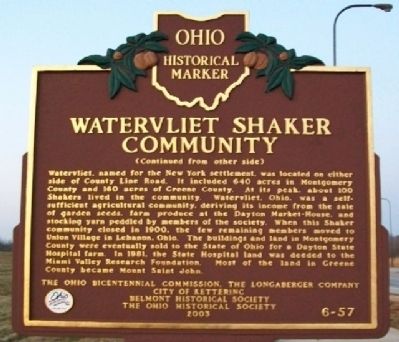
On Research Boulevard/County Line Road (Ohio Route 835) 0.1 miles north of Shakertown Road, on the left when traveling north.
Side A:
A Shaker village called Watervliet, Ohio, was located here from 1806-1900. The Shakers, originally called the United Society of Believers in Christ's Second Appearing, were followers of Mother Ann Lee who came from Manchester, England . . . — — Map (db m26345) HM
The Lincoln Highway, the nation's first east-west transcontinental highway, has an intimate history with Greene County. Stretching from New York City to San Francisco, its original construction was essentially a private promotional effort, created . . . — — Map (db m168843) HM
Near U.S. 9W at Peter Bronk Road, on the left when traveling north.
This homestead
has been in the Bronk
family since its erection
in 1663 and is given by its
present owner to the
Greene County
Historical Society
in memory of his mother
Adelaide Ely Bronk Lampman
The lower marker reads: . . . — — Map (db m313939) HM
Near U.S. 9W at Peter Bronk Road, on the left when traveling north.
Bronck House
Has been designated a
Registered National
Historic Landmark
under the provisions of the
Historic Sites Act of August 21, 1935
This site possesses exceptional value
in commemorating or illustrating
the history of the . . . — — Map (db m313940) HM
On Lord Avenue/Homestead Street north of Reservoir Street, on the left when traveling north.
Crystal Lake circa 1906
Crystal Lake was one of the first settlements of Fell Township. In 1818, Peter F. Ball came from New York state and built a log house near the lake. During the next decade, seven other men established homesteads . . . — — Map (db m104283) HM
On North Main Street 0 miles north of Court Street, on the right when traveling north.
In 1874, the Georgia Department of Agriculture was established by Act of the Legislature with Thomas P. Janes serving as its first Commissioner, 1874-79.
Commissioner Janes, born 1823 in present Taliaferro County, (formerly the eastern part of . . . — — Map (db m14726) HM
On Brush Run Road, on the left when traveling east.
[Marker Front]:
At the turn of the twentieth century, increased enrollment in the Combined Normal and Industrial Department at Wilberforce University (which later became Central State University) spurred construction of new teaching and . . . — — Map (db m14057) HM
On Main Street south of Dutchmans Landing Park Road, on the right when traveling south.
From the time of the first Native-Americans, the juncture of the Hudson River and Catskill Creek was an important geographical inroad westward. In 1807, Inventor Robert Fulton tested the first steam boat on the Hudson and began commercial operation . . . — — Map (db m304956) HM
On New York State Route 990V at Prattsville Road (County Route 39), on the right when traveling east on New York State Route 990V.
More than 150 years ago, a New York City newspaperman – in describing a treacherous and breathtaking stagecoach ride through Conesville - reported that he could not be bribed to repeat the journey but for one thing: "the scenery, Sir, the . . . — — Map (db m306520) HM
On New York State Route 990V 0.2 miles west of Bearkill Road (County Route 18), on the right when traveling east.
More than 150 years ago, a New York City newspaperman – in describing a treacherous and breathtaking stagecoach ride through Conesville - reported that he could not be bribed to repeat the journey but for one thing: "the scenery, Sir, the . . . — — Map (db m306877) HM
On East Main Street (State Highway 123) at South William Hooker Drive, on the right when traveling east on East Main Street. Reported permanently removed.
(preface)
On July 18, 1863, Union Gen. Edward E. Potter led infantry and cavalry from New Bern to destroy the Wilmington and Weldon Railroad bridge at Rocky Mount. The infantry feinted toward Kinston and returned to New Bern. Potter raided . . . — — Map (db m232003) HM
On South Main Street (State Highway 43) 0.3 miles south of West Avenue (State Highway 222), on the right when traveling south.
On July 18, 1863, Union Gen. Edward E. Potter led infantry and cavalry from New Bern to destroy the Wilmington and Weldon Railroad bridge at Rocky Mount. The infantry feinted toward Kinston and returned to New Bern. Potter raided . . . — — Map (db m76871) HM
On Grand Street 0.2 miles east of Fairview Avenue, on the right when traveling east.
Altamont Fairgrounds
The Albany Agricultural Society sponsored the first fair in Albany County in 1819. For the next 70 years fairs were held in Albany and in the surrounding towns and villages. In August 1892, local businessmen . . . — — Map (db m283615) HM
On Main Street at Bridge Street ( Route 385), on the right when traveling north on Main Street.
Sacred to the memory of
the Revolutionaries
of 1776 who, at great
personal risk, and with
aspirations to liberate
the thirteen colonies of
British North America,
endured the terrible
strife of a calamitous
war, and forever
consecrated . . . — — Map (db m304888) WM
On Durham Road at Potter Mountain Road (County Route 3), on the right when traveling south on Durham Road.
More than 150 years ago, a New York City newspaperman - in describing a treacherous and breathtaking stagecoach ride through
Conesville - reported that he could not be bribed to repeat the journey but for one thing: "the scenery, Sir, the . . . — — Map (db m249458) HM
On Mansion Street (New York State Route 385) south of Spencer Street, on the right when traveling north.
George H. Scott
Organizer and leader of
Volunteer firemen
First President
Greene County Firemen's Assn.
1889
Tri-county Firemen's Assn.
Columbia-Greene-Ulster
1890
which became
Hudson Valley Volunteer Firemen's Assn. . . . — — Map (db m313343) HM WM
On County Route 42 near U.S. 9W, on the left when traveling north.
About This Barn
Why does this barn have thirteen sides? We do not know, but the building itself is one variation of a type of farm building usually known as a round barn. Round barns have as few as five sides to as many as twenty, while . . . — — Map (db m176708) HM
Near Main Street north of Rices Landing Road (County Route 1010), on the left when traveling north.
Pennsylvania Railroad Company
Established in 1846, the Pennsylvania Railroad Company (PRR) was headquartered in Philadelphia, Pennsylvania. By 1882, it had become the largest railroad and transportation company in the world with a budget . . . — — Map (db m181582) HM
On West Court Street at South 3rd Street, on the right when traveling east on West Court Street.
Let us hold in honored memory those men from Greene County who gave their lives that mankind might hope for a better world. World War I
Ranzi Adams • Lon Austin • Charles J. Barnett • Jimmie Bonds • Arlin Boone • Luther F. Bowlin • William B. . . . — — Map (db m151233) WM
From here you see a long limestone ridge running north and south almost parallel to the Hudson (Nordt) River. The Dutch arriving here in the mid 1600s found a Native American trail on the limestone ridge (Kalkberg). The ancient well-traveled and . . . — — Map (db m314031) HM
Near Main Street (New York State Route 23), on the right when traveling west.
Zadock Pratt
October 30, 1790 to April 6, 1871
Born in Stephentown, Rensselaer County, New York
Buried in Prattsville, New York Cemetery
Tanner, Farmer, Builder, Banker
U.S. Congressman (1837-1839; 1843-1845)
Wives:
Beda . . . — — Map (db m137374) HM
On Buckeye Road (County Route 29) north of Mason-Dixon Highway (West Virginia Route 7), on the left when traveling north. Reported missing.
Branch of Warrior Trail of the Great Catawba Indian War Path located here where Mason and Dixon Survey crossed Dunkard Creek for third time. Guide, Six Nations Indians’ chief, declared he “would not proceed one step further,” because hostile . . . — — Map (db m175212) HM
On North Carolina Highway 58 (State Highway 58) at Fort Run Road (State Highway 1058), on the right when traveling south on North Carolina Highway 58.
Tuscarora stronghold. Site of decisive battle of the Tuscarora War, March 20-23, 1713, when 950 Indians were killed or captured. Site 1 mi. N. — — Map (db m222352) HM
Thin black lines indicate changes in relevance. Between each pair of lines entries are ordered geographically but all have the same relevance.
* Inflectional forms of words are their plurals, singulars, and possessives as well as gramatical tenses and similar variations.