Marker Logo
THE HISTORICAL
MARKER DATABASE
“Bite-Size Bits of Local, National, and Global History”


10 entries match your criteria.  


Entries Containing All of the Phrases «pasquotank county» AND «north carolina»

This list will also include matches for inflectional* forms of the words.
 
By Devry Becker Jones (CC0), June 14, 2025
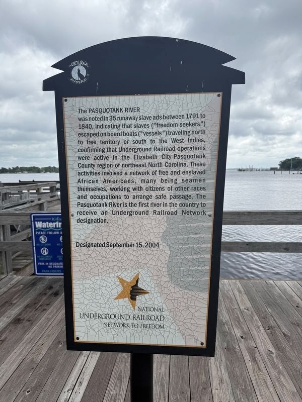
Pasquotank River Marker
RANKED BY RELEVANCE
1 ► North Carolina, Pasquotank County, Elizabeth City — 2004 — Pasquotank River —
Near South Water Street at East Ehringhaus Street, on the left when traveling south.
The Pasquotank River was noted in 35 runaway slave ads between 1791 to 1840, indicating that slaves (“freedom seekers”) escaped on board boats (“vessels”) traveling north to free territory or south to the West Indies, confirming that . . . — — Map (db m56811) HM

2 ► North Carolina, Currituck County, Coinjock — Albemarle and Chesapeake Canal — Military Supply Route
Near Old Coinjock Canal Road 0.2 miles east of Worth Guard Road, on the right when traveling east. Reported permanently removed.
After the Battle of Elizabeth City and the destruction of the Confederate Mosquito Fleet in February 1862, the Confederates scuttled ships to block the North Carolina cut. The Federals had the same idea to stall Confederate traffic and sent five . . . — — Map (db m56979) HM
3 ► North Carolina, Pasquotank County, Elizabeth City — A Town Divided — “… universal panic and distress” —
On East Main Street at North Elliot Street, on the right when traveling east on East Main Street.
During the Civil War, neither the North nor the South was totally united over the key issues. Just as some Northerners supported slavery and secession, some Southerners were abolitionist and Unionists. These issues could split families, . . . — — Map (db m56770) HM

4 ► Virginia, Chesapeake, Greenbrier West — Battle of Great Bridge DAR Monument — December 9, 1775 —
Near Watson Road at North Battlefield Boulevard (Virginia Route 168), on the left when traveling south.
(side 1) This monument honors Patriots who assembled at this site in the Cause of American Freedom in 1775 American Patriots at the Battle Second Virginia Regiment Commanded by Colonel William Woodford, of . . . — — Map (db m211239) HM

5 ► North Carolina, Pasquotank County, Elizabeth City — Celebrating 100 years of Women's Right to Vote 1920-2020 —
On South Water Street north of Shepard Street, on the left when traveling north.
As we mark the occasion of the 100th anniversary of the women's right to vote, we honor our foremothers — the brave women suffragists around the United States who protested and picketed for their constitutional right to vote. The ratification of . . . — — Map (db m276339) HM

6 ► North Carolina, Pasquotank County, Elizabeth City — A-21 — Culpeper’s Rebellion —
On South Water Street near East Church Street, on the right when traveling north.
Culpeper and Durant led a Revolt against British trade laws, seized the government 1672, 2 mi SE. — — Map (db m284108) HM
7 ► North Carolina, Pasquotank County, Elizabeth City — A-43 — Mount Lebanon Church —
On West Ehringhauas Street (U.S. 17) at Culpepper Street, on the right when traveling west on West Ehringhauas Street.
A.M.E. Zion. Organized about 1850 as mission to serve black Methodists. Since 1856 congregation has met 1½ blocks N. — — Map (db m5528) HM
8 ► Tennessee, Davidson County, Bellevue — Devon Farm —
Near Ensworth Drive south of Tennessee Highway 100, on the right when traveling south.
This property has been placed on the National Register of Historic Places by the United States Department of the Interior — — Map (db m200320) HM

9 ► North Carolina, Pasquotank County, Elizabeth City — A-54 — George W. Brooks —
On West Ehringhause Street (U.S. 17) north of Westover Street, on the left when traveling west.
Federal judge whose writs of habeas corpus, 1870, prevented arbitrary arrest of N.C. citizens during Reconstruction. Home was ¼ mile east. — — Map (db m2772) HM

Paid Advertisement
10 ► North Carolina, Pasquotank County, Elizabeth City — A-39 — J. C. B. Ehringhaus —
On Sourthern Avenue north of Riverside Avenue, on the right when traveling north.
Governor, 1933-1937, friend of education, member of General Assembly, solicitor. Birthplace ¼ mile North. — — Map (db m2774) HM
 
    Thin black lines indicate changes in relevance. Between each pair of lines entries are ordered geographically but all have the same relevance.
* Inflectional forms of words are their plurals, singulars, and possessives as well as gramatical tenses and similar variations.
 
CeraNet Cloud Computing sponsors the Historical Marker Database.
This website earns income from purchases you make after using our links to Amazon.com. We appreciate your support.
Paid Advertisement
Nov. 20, 2026