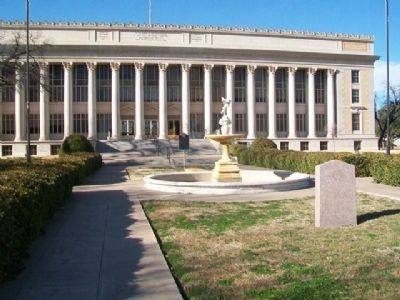
On Beauregard Avenue west of Irving Street, on the right when traveling west.
On transcontinental trail of California Gold Rush. Until 1846 a part of Bexar Land District, Republic of Texas. Private tracts were surveyed as early as 1847. German Emigration Company colony (90 mi. SE) had grants here, but in 1840s found . . . — — Map (db m71965) HM
On Irving Street north of Beauregard Avenue, on the left when traveling north.
Sponsor of 1918 measure to give Texas women right to vote.
Born in Lawrence County, Tenn. Came to Texas 1872. Helped map town site of Ben Ficklin, first county seat, Tom Green County.
Grew first bale of cotton and installed first . . . — — Map (db m71967) HM
On Beauregard Avenue at Irving Street, on the right when traveling west on Beauregard Avenue.
To the memory of the heroic
pioneers of West Texas,
this building is dedicated.
Men's homage and their love
shall never cease to follow them.
———————
Tom Green County Courthouse
has been . . . — — Map (db m71966) HM
On Beauregard Avenue west of Irving Street, on the right when traveling west. Reported missing.
[Side A]
Led 5th Texas Cavalry Battle Val Verde
in Arizona-New Mexico Campaign 1861
1862 Commanded "Cotton Clad" carrying
cavalrymen dubbed "Horse Marines" in
recapture Galveston January 1863. Made
Brigadier General while leading . . . — — Map (db m126723) HM
Near U.S. 277 0.1 miles south of Main Street (Loop Highway 110), on the right when traveling north.
The picnic area on US 277 in Tom Green County is an early roadside park developed by the Texas Highway Department -- now Texas Dep't of Transportation. This 1935 park accommodated motorists attending Texas Centennial events in 1936. It was . . . — — Map (db m104049) HM
On North 6th Street south of Main Street (Loop State Highway 481), on the right when traveling north.
Author, attorney and politician Ovie Clark Fisher (1903-1994) was born at the Kimble County ranch home of his parents, Jobe and Rhoda (Clark) Fisher. He graduated from Junction High School and received a law degree from Baylor University. He married . . . — — Map (db m126782) HM
On Knickerbocker Road at Hillside Drive, on the right when traveling south on Knickerbocker Road.
Colorful pioneer and Texas Ranger who helped to create civilization and institutions of West Texas. Owned ranch land on which today is situated Lake Nasworthy – first conservation lake in this area.
Born in Georgia. Served 1864–1865 in . . . — — Map (db m116065) HM
On Avenue E at 10th Street, on the left when traveling west on Avenue E. Reported missing.
In 1892 Claude B. Hudspeth (1877-1941) began publication of a weekly newspaper called the "Ozona Kicker." Following his three-year ownership, Hudspeth entered politics, serving first in the Texas Legislature and later as representative from the . . . — — Map (db m300816) HM
On U.S. 67 2.4 miles east of State Highway 137, on the left when traveling west. Reported missing.
Formed from Tom Green County; created March 7, 1903, organized April 20, 1903. Named in honor of John H. Reagan 1818-1905. Indian fighter and surveyor member of Texas Legislature and United States Congress postmaster general of the southern . . . — — Map (db m63594) HM
On Grape Creek Road 0.1 miles south of Tomahawk Lane, on the right when traveling north.
An early stagecoach stop near here provided the foundation for a frontier community. In the mid-19th century, stage lines were a primary means of moving people, mail and supplies through the region. John Butterfield, president of the Overland Mail . . . — — Map (db m95950) HM
German native William Klattenhoff (1855–1928) immigrated to Texas in 1872 at age 17. His work on the International and Great Northern Railroad brought him to Hutto, where he purchased land in 1876. Upon his marriage to Alvina Plattow . . . — — Map (db m4441) HM
Near Main Street (Loop Highway 110) at Church Street, on the right when traveling north.
Along the banks of the South Concho River, Confederate veterans of the War Between the States (1861-1865) gathered in reunion beginning in 1902. They were members of the United Confederate Veterans Colorado—Concho Confederate Reunion . . . — — Map (db m115960) HM
On Hall Street at Almond Street, on the right when traveling south on Hall Street.
George Smith, born a slave in Virginia, and later a Buffalo Soldier and school trustee in Tom Green County, arrived in Brownwood in 1885 and established the town's first school for African-American children. His home and yard on Dale Street became . . . — — Map (db m248294) HM
On Business Interstate 20 east of Newell Road, on the left when traveling east.
Created February 26, 1887
from Tom Green County
Organized January 15, 1891
Named in honor of
Matthew Duncan Ector
1822-1879
Member of the Texas Legislature
A Confederate Officer and
outstanding jurist
Odessa, The County . . . — — Map (db m86704) HM
On U.S. 87 at Hunt Rd, on the right when traveling south on U.S. 87.
The pioneer settlement of Cummins developed at this site about 1890 around the saddle and harness shop of the earliest permanent settler, Mississippi native Robert Benjamin Cummins (b. 1848). A post office opened here in 1890 with J. H. Kellis as . . . — — Map (db m125262) HM
On State Highway 158 0.1 miles west of Scott Lane, on the right when traveling west.
Formed from Tom Green County
Created March 13, 1889
Organized April 23, 1889
Named in Honor of
Richard Coke
1829 - 1896
Governor of Texas 1874-1876
Member of United States Senate
1878 - 1896
County Seat, . . . — — Map (db m82995) HM
Thin black lines indicate changes in relevance. Between each pair of lines entries are ordered geographically but all have the same relevance.
* Inflectional forms of words are their plurals, singulars, and possessives as well as gramatical tenses and similar variations.