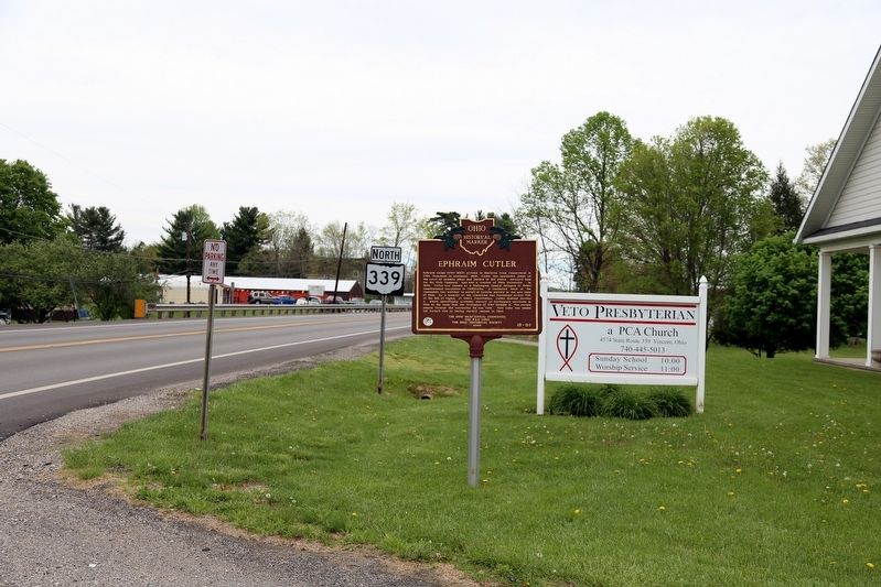
On Ohio Route 339 at Veto Road (County Route 3), on the right when traveling north on Ohio Route 339.
Ephraim Cutler (1767-1853) arrived in Marietta from Connecticut in 1795. Prominent in southeast Ohio, Cutler was appointed judge of the court of common pleas and justice of the peace, surveyed land for the Ohio Company, and was a trustee of Ohio . . . — — Map (db m103728) HM
On West Carpenter Street just east of North Congress Street, on the right when traveling west.
Beginning as a congregation in 1872 inside a private home, the first Mount Zion Baptist Church building in Athens was on Lancaster Street in 1876. Between 1905 and 1909, a thriving community of free-born and formerly enslaved Black Americans built . . . — — Map (db m248625) HM
On Ohio Route 13 south of Main Street, on the right when traveling south.
In the first quarter of the nineteenth century, when the general public
believed that the insane and paupers could be rehabilitated into productive
citizens, the Ohio Legislature gave authorization to county commissioners
to establish county . . . — — Map (db m122758) HM
On West Clinton Street at Washington Road, on the right when traveling west on West Clinton Street.
Albany. The village of Albany was established in 1838 as a market center for the surrounding agricultural area, which saw its first white settlement in the early years of the nineteenth century. Education was always a major concern of Albany's . . . — — Map (db m52872) HM
On State Street (Ohio Route 550) 0.1 miles south of Main Street ( Route 329), on the right when traveling east.
Ohio was an incredibly important state to railroads; one of the nation's first opened in 1839, the Mad River & Lake Erie (a future component of the New York Central), and key cities were located there offering substantial business for the . . . — — Map (db m247090) HM
Near West Bailey Road 0.1 miles west of Converse Street ( Route 13), on the left when traveling west.
During the War of the Rebellion three young men from Chauncey traveled to Parkersburg and Clarksburg, VA., to enlist in what was then the 1st Virginia Cavalry (USA). These "Loyalist Regiments” became West Virginia regiments in June 1863 just . . . — — Map (db m242161) HM
On Mound Street at Gary Street, on the right when traveling west on Mound Street.
The Adena Culture was a Pre-Columbian Native American Culture that existed from 1000 B.C. to 100 A.D. in a time known as the Early Woodland Period. The Adena People existed throughout present day Ohio and its neighboring states.
The Adena . . . — — Map (db m174985) HM
On Ohio Route 124 0.1 miles south of Local Highway 153, on the left when traveling north.
Department of the Ohio - Maj. Gen. Ambrose E. Burnside
Cavalry Brigade, 3rd Division XXIII Corps - Brig. Gen. Henry M. Judah
5th Indiana Cavalry (2 companies) (Lt. John O'Neil)
11th Kentucky Cavalry (Maj. Milton Graham)
14th Illinois . . . — — Map (db m35744) HM
On O D N R Mohican Road 51 at Hog Hollow Trail, on the right when traveling east on O D N R Mohican Road 51.
Ohio Forest Fire Management Through The Years
1885 - The Ohio General Assembly established the State Forestry Bureau.
1915 - The General Assembly appropriated $10,000 for the purchase of two forested areas in southern Ohio: Waterloo State . . . — — Map (db m269963) HM
On Stoney Creek Road (State Road 372) near North Ridge Road.
1885 -
The Ohio General Assembly established the State Forestry Bureau.
1915 - The General Assembly appropriated $10,000 for the purchase of
two forested areas in southern Ohio: Waterloo State Forest in
Athens County and Dean State Forest in . . . — — Map (db m247892) HM
On Mineral Springs Road (County Route 18) north of Garnet Shiveley Road, on the right when traveling south.
Medicinal value of springs promoted by Charles Matheny, 1840. First hotel built 1864 and resort named Sodaville. Under ownership of General Benjamin Coates, 1888–91, Smith Grimes 1891–08, and J. W. Rogers 1908–20. Mineral Springs Health Resort . . . — — Map (db m132963) HM
Near West Union Street (Ohio Route 56) east of Hospital Drive, on the left when traveling east.
(side A)
Born a slave in Texas on August 1, 1844, Holland was brought to the integrated Albany Manual Labor University in 1851 by his friend and owner where he learned the trade of shoemaker. He acted as a servant to Colonel Nelson Van . . . — — Map (db m173925) HM
On Richland Avenue at South Shafer Street and South Green Drive, on the left when traveling north on Richland Avenue.
Silas Bingham arrived in Athens in 1797. His home, originally built on South College Street, is the oldest house in Athens and one of the few remaining examples of a two-story log building in the area.
Since the commissioners held meetings in . . . — — Map (db m10909) HM
On Ohio Route 327 at Fairgreens Road, on the right when traveling south on Ohio Route 327.
The Underground Railroad was neither underground nor a railroad, but a system of loosely connected safe havens (called stations) where those escaping the brutal conditions of slavery (known as passengers) were sheltered, fed, clothed, and . . . — — Map (db m309383) HM
On Lee Highway (U.S. 211) at View Town Road (County Road 642), on the right when traveling east on Lee Highway.
Eliza Brown was a slave on the Pierce farm several miles west of here. When Union Gen. George Armstrong Custer camped here in August 1863 after the Battle of Gettysburg, he hired her to be his servant and cook. Custer's wife, Libbie, mentioned . . . — — Map (db m173058) HM
On Court Street at Washington Street, on the right when traveling south on Court Street.
To honor and commemorate
the Revolutionary Soldiers
buried in Athens County, Ohio
Daniel Anderson •
Thomas Arnold •
Isaac Barker •
Ebenezer Barrows •
Hopson Beebe •
Alvan Bingham •
Silas Bingham, Sr. •
William Bodwell •
John Bowman . . . — — Map (db m15544) WM
Thin black lines indicate changes in relevance. Between each pair of lines entries are ordered geographically but all have the same relevance.
* Inflectional forms of words are their plurals, singulars, and possessives as well as gramatical tenses and similar variations.