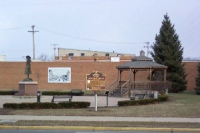
On Broadway Street (Ohio Route 118) at Main Street ( Route 49), on the right when traveling north on Broadway Street.
One of America's best-known sport shooters and entertainers of the late 1800s, Annie Oakley was born Phoebe Ann Mosey (or Mozee) north of Versailles in Darke County in 1860. She achieved local fame for her shooting ability as a hunter while still in . . . — — Map (db m205096) HM
On North Broadway Street at Wilson Drive, on the right when traveling north on North Broadway Street.
Citizen, businessman, public servant—a true supporter of the community and its individuals.
The values of faith, family, and freedom have guided this gentleman through the years. A devout Lutheran with music as an inherent part of his life, . . . — — Map (db m306821) HM
On Wilson Drive 0.2 miles east of North Broadway Street ( Route 118), on the right when traveling east.
Gen. William Henry Harrison, United States
Gov. Lewis Cass, Michigan Territory
A Bowery was built to conduct treaty negotiations
with eight Native American Indian Nations
Wyandot, Delaware, Shawanee, Ottawa,
Seneca, Miami, . . . — — Map (db m193031) HM WM
On Main Street (U.S. 127) 0.2 miles north of U.S. 127, on the right when traveling north.
The army of Maj. Gen. Arthur St. Clair camped on the southern margin of Maple Swamp at the headwaters of Twin Creek. One and a half miles west of this site at noon on October 11, 1791 A.D. on account of the marshy condition of the ground it was . . . — — Map (db m119902) HM
Near Fort Nesbit Eaton Road (County Route 138) 0.2 miles south of Gibbs Road (County Route 246). Reported missing.
Built on this high ridge, Fort Nesbit (Nisbet) offered protection for settlers, travelers, and army supply trains in northern Preble and southern Darke counties during the War of 1812. It was part of a chain of forts that extended from Fort St. . . . — — Map (db m75106) HM
On Stingley Road (County Route 57) 0.2 miles west of Smith Road (County Route 386), on the left when traveling west.
James and Sophia Clemens’ lives are part of a story of tens of thousands of people of color who migrated north in search of land to farm and better lives during the first half of the 19th century. In 1818, James Clemens (1781-1870) purchased 387 . . . — — Map (db m168860) HM
On North Bridge Street at Ohio to Indiana Trail, on the right when traveling north on North Bridge Street.
The Darke County Connection
Citizens of the Miami Valley were made aware of Lincoln's funeral train through announcements in local newspapers. Sunday April 30, the train traveled into Darke County on a wet and chilly night. The train . . . — — Map (db m251661) HM
Near North Star- Fort Loramie Rd (County Route 18).
While at this site, imagine
the legendary Annie Oakley
“Little Sure Shot”
Standing and gazing at
her family’s graves
Father
Jacob Mosey (Moses)
1799- 1866
four of her siblings
Mary Jane 1851-1867
Elizabeth . . . — — Map (db m128361) HM
On West Franklin Street at South Main Street, on the right when traveling west on West Franklin Street.
The Indiana General Assembly authorized the formation of Randolph County from Wayne County in January 1818 to take effect in August 1818. Early historians contend that the county's name came from settlers who relocated from Randolph County, North . . . — — Map (db m225004) HM
Annie Oakley's real name was Phoebe Moses and she was born in Darke County, Ohio in 1860. She helped her family survive by hunting and selling game, or wild animals. Though she learned to use a rifle for practical reasons, she eventually became a . . . — — Map (db m228054) HM
On East Harmon Drive at East Park Drive, on the right when traveling north on East Harmon Drive.
Dedicated Oct. 20, 2019
A project sponsored by the Friends of the Greenville City Parks and by an Ohio Department of Natural Resources Grant
Chief Little Turtle sculpture created by Joshua Shepherd
Chief Little Turtle "Me-she-kin-no-quah" . . . — — Map (db m251741) HM
On Greenville-St Marys Brock Road South 0.2 miles south of Route 185, on the right when traveling north.
Side A Phoebe Ann Mosey, also known as Annie Oakley, was born six miles northeast of here in what was then Woodland, later renamed Willowdell. Born in 1860 she was the sixth daughter born to Jacob and Susan Mosey. After the death of her . . . — — Map (db m59641) HM
On Shenandoah Road (County Route 112), on the right when traveling north.
The USS Shenandoah made its maiden flight on September 4, 1923. An impressive achievement, it had cost the government $2.9 million to construct. America's first lighter-than-air rigid airship, designated the ZR-1 (Zeppelin Rigid 1), was . . . — — Map (db m309397) HM
On S. Main Street, on the left when traveling south.
Named for General Hugh Mercer, a distinguished officer of the Revolution, Mercer County was established in 1820 by a
legislative act creating counties from the land within Ohio ceded by the Indians. The configuration of the County
then included . . . — — Map (db m193092) HM
On North Broadway Street (Ohio Route 118) at Garst Avenue, on the left when traveling north on North Broadway Street.
This marker honors the memory of a beloved native of Darke
County, the famous sharp- shooter,
Annie Oakley. Within a radius of
a few miles of this site Annie- -
Was born at Woodland (Willow Dell)
Spent her early childhood at . . . — — Map (db m87126) HM
On Ohio Route 127 near Cohee when traveling south.
Annie Oakley America's "Little Sure Shot" was born in northeastern Darke County, Ohio, and spent her childhood days in the house on this site. At that time the dense virgin forest surrounded her home and Annie shot and trapped wild game to help pay . . . — — Map (db m82177) HM
On North Broadway Street (Ohio Route 118) at Wilson Drive, on the right when traveling north on North Broadway Street.
In 1870, George Buchy fled the Alsace-Lorraine region when it was invaded by Germany and immigrated to the United States with the equivalent of $.85 to his name. He continued his travels from New York to Pittsburgh along the Ohio River then to . . . — — Map (db m193027) HM
On North 2nd Street at East Main Street (State Route 47), on the right when traveling south on North 2nd Street.
Original Plat of (Jacksonville) Versailles by Silas Atchison - August 28, 1819
The history of the village passed through several name changes; from Jacksonville (1819-1837) to Versailles (1837-1854); then added North Jacksonville (1842-1854) . . . — — Map (db m252785) HM
On McConnelsville Road (Ohio Route 78), on the right.
The USS Shenandoah made its maiden
flight on September 4, 1923. An impressive
achievement, it had cost the government
$2.9 million to construct. America's first
lighter-than-air rigid airship, designated the
ZR-1 (Zeppelin Rigid 1), was . . . — — Map (db m166293) HM
Near West Street at Union Street, on the right when traveling south.
south side
Erected & donated A.D. 1903
by Frank McWhinney & wife
in honor and memory
of the Union soldiers
of Darke County, Ohio,
living or dead, who served
in the War of 1861-1865.
Also, of all soldiers
of Darke County, . . . — — Map (db m93156) WM
On Elm Street at Park Avenue, on the left when traveling north on Elm Street.
Most of the homes in this district were constructed after the creation of the Mackinaw Development Corporation in 1887. The corporation was named for the Cincinnati, Jackson, and Mackinaw Railroad which arrived in Franklin from Darke County in 1886. . . . — — Map (db m67652) HM
On U.S. 83 at 2nd Street, on the left when traveling north on U.S. 83.
At a time when shooting was America's second most popular spectator sport (after horse racing), Annie Oakley (1860-1926) was the superstar. She was born Phoebe Ann Moses in Darke County, Ohio. Her family was extremely poor, and she learned to . . . — — Map (db m66063) HM
On South Broadway Street (Ohio Route 49/121) just south of West 4th Street, on the right when traveling south.
In recognition of
the patriotism of
the people of
Darke County
who oversubscribed their
War Savings Quota in 1918
this tablet is
gratefully erected by the
Ohio War Savings Committee — — Map (db m214740) HM WM
On Ohio Route 114 at Route 694, on the right when traveling north on Ohio Route 114.
Home in the wilderness 1821-1870. Built in 1821 downstream a quarter mile on the Auglaize west bank by Sebastian Sroufe, War of 1812 veteran, and wife Mary, this home was postal stop Sugar Grove on the Ft. Recovery-Ft. Defiance route and in 1828, . . . — — Map (db m79533) HM
Thin black lines indicate changes in relevance. Between each pair of lines entries are ordered geographically but all have the same relevance.
* Inflectional forms of words are their plurals, singulars, and possessives as well as gramatical tenses and similar variations.