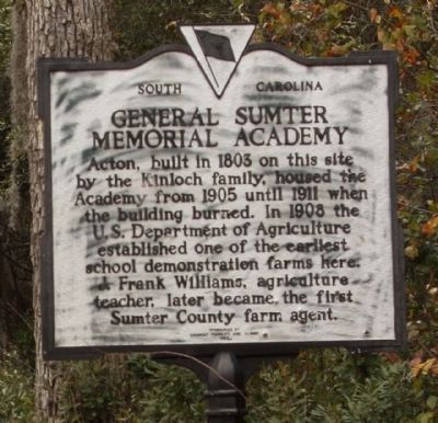
On Acton Road near Meeting House Road (South Carolina Highway 43-488), on the right when traveling south.
(Front text)
This forerunner of the modern consolidated rural high school with Colonel John Julius Dargan, noted educator, as founder and principal, offered classes in agriculture, home economics, and music. Day students from four . . . — — Map (db m27829) HM
On Broad Street (Business U.S. 76) west of Hospital Circle, on the right when traveling west.
Community Hospital opened at this site in 1949. The 40-room brick facility was built for African American residents of Sumter and outlying areas who were underserved by white-owned Tuomey Hospital, which had a segregated wing for Black patients. . . . — — Map (db m301515) HM
Statesman • Diplomat • Naturalist
Founder, National Institution for the
Promotion of Science, forerunner of
the Smithsonian Institution
• First United States Minister to Mexico •
• United States Secretary of War •
While serving . . . — — Map (db m8087) HM
On South Main Street at West Court Street on South Main Street.
[Front]:
Born in Charleston, S.C., educated in this country and Great Britain, he travelled widely in Europe and Asia before returning to a distinguished career. He served South Carolina in the state legislature, 1816-1820; 1830-1832; . . . — — Map (db m9187) HM
On Law Range east of North Main Street, on the right when traveling east.
This law office was constructed by Shepard Kollock Nash in 1936-1937. "Shep" Nash graduated from Sumter High School in 1911 and attended Davidson College. He read law in Sumter and was admitted to the South Carolina Bar in 1917. Nash served in . . . — — Map (db m224570) HM
On Main Street (State Highway 23) at Buncombe Street (U.S. 25), in the median on Main Street.
From its earliest history, Edgefield developed a reputation for violence. The bloody fighting of the Cherokee War of 1760 was followed by years of lawlessness and retribution during the Regulator period. period. During the American Revolution . . . — — Map (db m12534) HM
McDuffie was a strong advocate for the right of states to nullify or void acts of Congress within their borders. He developed and promoted the Nullification Theory & also served in the U.S. House and U.S. Senate. — — Map (db m12878) HM
On Main Street (U.S. 25) near Penn Street (South Carolina Highway 23), on the left when traveling west.
A tribute to the Governers
and Lieutenant Governors of South
Carolina who were
natives of or at one time
residents of Edgefield
District or County.
Governors
Andrew Pickens II (1816-18)
George McDuffie (1834-36)
Pierce Mason . . . — — Map (db m12645) HM
On Simpkins Street, on the right when traveling north.
Site of law offices of
Eldred Simkins
Congressman, Lt.-Governor
George McDuffie
Congressman, Governor,
U.S. Senator
Francis W. Pickens
Congressman, Governor,
Minister to Russia
Francis H. Wardlaw
Author of . . . — — Map (db m12657) HM
On North Church Street (U.S. 29) south of East North Street (South Carolina Highway 183), on the right when traveling north.
Started in 1820 as St. James' Mission, the first church built here in 1825 on land given by Vardry McBee, was consecrated in 1828 by Bishop Nathaniel Bowen as Christ Church. The present church was built 1852-54 with Rev. John D. McCollough as . . . — — Map (db m8506) HM
On State Highway 81 at Morrah Bridge Road (County Route 39), on the left when traveling north on State Highway 81.
Cherry Hill
Three miles southwest is "Cherry Hill," site of the home of George McDuffie (1790-1851), orator of nullification, member of the U.S. House of Representatives and the U.S. Senate, Major General of the State Militia, and Governor of . . . — — Map (db m11461) HM
On Elliott Street, on the right when traveling west.
Elisha Poinsett
————
Builder
His descendant,
Joel Roberts Poinsett
one time Ambassador
to Mexico, introduced
the Poinsettia
to the United States — — Map (db m50482) HM
On South Main Street (State Highway 124) at East Broad Street, on the left when traveling south on South Main Street. Reported permanently removed.
The most controversial of Greene's Militia commanders, Sumter was known for his trademark gamecock feather in his hat, his tenacity and his penchant for bloody frontal assaults - characteristics that earned him the moniker "The Gamecock."
. . . — — Map (db m259652) HM
On North Main Street at Law Range, on the right when traveling north on North Main Street.
(Front text) By Act of 1798, Commissioners were named "To ascertain and fix upon the most central place for the erection of a court house in the District of Sumter", and meanwhile "to fix upon a proper place for the sitting of the court". . . . — — Map (db m27361) HM
On Court Square (State Highway 28) south of Washington Street (State Highway 203), on the right when traveling north.
Abbeville's 6th courthouse - designed in beaux arts classical style by Edwards & Walter of Atlanta - dedicated in 1908 with City Hall/Opera House. (Two buildings indirectly financed by profits from Abbeville Dispensary, only one still operating . . . — — Map (db m14870) HM
Near Newcastle Street north of North Street, on the left when traveling north.
Born in Stateburg, Sumter County, SC: October 7, 1821
Graduated from West Point: 1842
Served with distinction in Mexican War: 1846-1848
Served at Cavalry School in Carlisle, PA. and wed Sarah Gibson: 1850
With the secession of South . . . — — Map (db m148756) HM
On Action Road, on the right when traveling south.
(West face)
This stone marks the grave of one of South
Carolina's most distinguished citizens,
Thomas Sumter. One of the founders of the Republic.
Born in Virginia August 14, 1734. Died June 1, 1832
(Lower . . . — — Map (db m28532) HM
On South Main Street East near Liberty Street, on the left.
(Left text)
A Railroad Town
As with many rural South Carolina towns,
Mayesville grew up around a railroad depot.
The Wilmington and Manchester Railroad
built the depot in 1853 on land owned by
Matthew Peterson Mayes, known to . . . — — Map (db m29430) HM
On North Main Street, on the right when traveling north.
The Henry Lee Scarborough House was built 1908-09 by Scarborough (1866-1929), a leading Sumter County farmer, businessman, and public servant serving as county treasurer (1894-1902), commissioner of public works for six years and clerk of court . . . — — Map (db m29202) HM
Near Manning Road (U.S. 521) at South Guinard Parkway (U.S. 521), on the right when traveling south.
Sumter Experiences the Civil War First Hand
In early 1865, the Civil War was coming to a conclusion after four long and bloody years of fighting. Union General Ulysses S. Grant's army had broken Confederate General Robert E. Lee's line . . . — — Map (db m253002) HM
[Front]:
This school, often called Retreat Colored School, was built in 1923 for the African-American students in and near Westminster. A two-room, two-teacher, elementary school, it was built by local builder William Walker Bearden of . . . — — Map (db m53235) HM
On Horatio- Hargood Road (State Highway 37), on the left when traveling west.
Since before 1808, the Lenoir family have operated a general store at the site of Horatio, S. C. Lenoir's Store is mentioned in the 1808 will of Isaac Lenoir, and later appears on Mills's 1825 map and McLaurin's 1878 map of Sumter County. The . . . — — Map (db m27824) HM
Thin black lines indicate changes in relevance. Between each pair of lines entries are ordered geographically but all have the same relevance.
* Inflectional forms of words are their plurals, singulars, and possessives as well as gramatical tenses and similar variations.