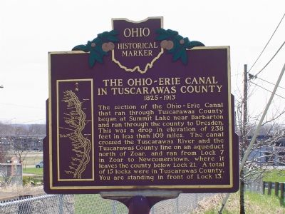
On Commercial Avenue SE (Ohio Route 416) at Canal Avenue SE, on the left when traveling south on Commercial Avenue SE.
1825–1913. Seeking an alternative transportation route to distant markets, many farmers and manufacturers in Ohio wanted to connect the Ohio River to Lake Erie with a canal. Beginning in Cleveland the Ohio-Erie Canal ran south, the length of the . . . — — Map (db m293) HM
On High Avenue near Broadway Avenue, on the right when traveling west.
United States of America
Congressional Medal of Honor Recipients
State of Ohio, Tuscarawas County Civil War
Archinal, William J. Corporal Mississippi 1863
Blickensderfer, Milton A. Sergeant Virginia 1865
Campbell, William . . . — — Map (db m15246) HM
On East High Avenue (Ohio Route 39) at North Broadway Street ( Route 800), on the right when traveling west on East High Avenue.
When David Knisely, the founder of New Philadelphia, first arrived in the Tuscarawas Valley on August 27, 1803, he found a sparsely populated, pristine wilderness. Five years later the state legislature approved a bill organizing Tuscarawas County . . . — — Map (db m292) HM
On Dover Zoar Road NE (County Route 82) at Towpath Road NE (County Route 111), on the right when traveling north on Dover Zoar Road NE.
Construction of the Ohio and Erie Canal, beginning in Cleveland and running south to Portsmouth, began in 1825. As a means to pay for debts on the community's 5,500 acres of Tuscarawas County land, members of the Society of Separatists of Zoar . . . — — Map (db m224969) HM
On Sherman Church Road (County Route 102) near 12221 Sherman Church Rd NE, on the right when traveling south.
Treaty of Greene Ville
With the signing of the Treaty of Paris in 1763, England lost the American
Revolution and ceded to the former colonies land from the Atlantic Ocean
to the Mississippi River. By this time, pioneer settlers had reached . . . — — Map (db m77320) HM
On Newport Avenue 0.1 miles south of Trenton Avenue, on the right when traveling north.
Uhrich's Mill 1806
Michael Uhrich, Sr. founded Uhrich's Mill on this site in 1806. Uhrich emigrated from Pennsylvania in 1804 and became one of the first County Commissioners upon the formation of Tuscarawas County in February 1808. In . . . — — Map (db m224975) HM
On North Ray Street (Ohio Route 93) north of Route 651, on the left when traveling north.
Bouquet’s Trail, 1764. Unsatisfied by the treaty that ended the French and Indian War, Ottawa chief Pontiac led a confederacy of Native American tribes in attacks against the British frontier forts during 1763, a campaign known as “Pontiac’s . . . — — Map (db m13615) HM
On Center Street at North 4th Street, on the right when traveling east on Center Street.
Side A
Dennison Yard and Shops
Panhandle Division, Pennsylvania Railroad
The Pittsburgh, Cincinnati, and St. Louis Railway began construction of the Dennison Railroad Shops here in 1864. This rail line was chartered as the . . . — — Map (db m81546) HM
The Ohio-Erie Canal 1825-1913
Seeking an alternate transportation route to distant markets, many farmers and manufacturers in Ohio wanted to connect the Ohio River to Lake Erie with a canal. Beginning in Cleveland the Ohio-Erie Canal ran south, . . . — — Map (db m15190) HM
On Winklepleck Road (County Route 73) at Route 516, on the right when traveling east on Winklepleck Road.
The Bouquet Expedition Camp 14
Desperately trying to protect their homeland, the Delaware Indian Nation who lived here in the Tuscarawas Valley, joined the French against the English during the French and Indian War, 1754-1763. After the . . . — — Map (db m81571) HM
On Commercial Avenue SE (Ohio Route 416) south of Cookson Avenue SE, on the left when traveling south.
Here, on April 10, 1779 during the Revolutionary War, David Zeisberger founded one of the five Delaware Christian missions to occupy the Tuscarawas Valley between May 3, 1772 and September 8, 1781. Living at the Lichtenau mission near the Delaware . . . — — Map (db m295) HM
On U.S. 36 at Salem Park Road (Local Route 213), on the left on U.S. 36.
Here, on April 6, 1780 during the American Revolutionary War, a contingent of Delaware Christian Indians, led by John Heckwelder, an assistant to Moravian missionary David Zeisberger, founded the last of five missions to occupy the Tuscarawas Valley . . . — — Map (db m296) HM
On Main Street (Ohio Route 49) at Main Street ( Route 121), on the right when traveling north on Main Street.
Following General Anthony Wayne's victory at Fallen Timbers, members of the western tribes assembled at Fort Greene Ville to settle on terms of peace. Representatives of the Wyandot, Delaware, Shawnee, Ottawas, Chippewa, Ottawa, Pattawatimi, . . . — — Map (db m244967) HM
On Ohio Route 78 at Unionville Road, on the right when traveling west on Ohio Route 78.
Big Muskie. On May 22, 1969, Central Ohio Coal Company invited dignitaries to Muskingum Mine for the unveiling of the world's largest drag-line: the Bucyrus - Erie model 4250W affectionately named "Big Muskie." Four crews worked together to . . . — — Map (db m283625) HM
On Bolanz Road east of Riverview Road (County Route 9), on the right when traveling east.
The Ohio & Erie Canalway celebrates the first 110 miles of a waterway that helped the nation grow.
Dug by hand from 1825 to 1832, the Ohio & Erie Canal was the first canal west of the Appalachian Mountains. It connected Lake Erie to the Ohio . . . — — Map (db m202479) HM
Near Valley Parkway east of Riverview Road, on the left when traveling east.
The Ohio & Erie Canalway celebrates the first 110 miles of a waterway that helped the nation grow.
Dug by hand from 1825 to 1832, the Ohio & Erie Canal was the first canal west of the Appalachian Mountains. It connected Lake Erie to the Ohio . . . — — Map (db m224609) HM
On West Street west of Columbus Road, on the right when traveling west.
The Ohio & Erie Canalway celebrates the first 110 miles of a waterway that helped the nation grow.
Dug by hand from 1825 to 1832, the Ohio & Erie Canal was the first canal west of the Appalachian Mountains. It connected Lake Erie to the Ohio . . . — — Map (db m296753) HM
Near Boston Mills Road at Ohio & Erie Canal Towpath Trail, on the right when traveling east.
The Ohio & Erie Canalway celebrates the first 110 miles of a waterway that helped the nation grow.
Dug by hand from 1825 to 1832, the Ohio & Erie Canal was the first canal west of the Appalachian Mountains. It connected Lake Erie to the Ohio . . . — — Map (db m202381) HM
Near Canal Road south of East Front Street ( Route 800).
The Dover Light Plant. Electric lighting became practical after Thomas Edison patented his light bulb in 1880. In Dover, a privately-owned company provided power to the downtown's electric streetlamps. Community leaders believed that they . . . — — Map (db m225418) HM
On Broadway Street (Ohio Route 416) at High Avenue ( Route 39), on the right when traveling north on Broadway Street.
In recognition of the patriotism of the people of Tuscarawas County who so generously purchased War Saving Stamps in 1918 this tablet is gratefully erected by the Ohio War Savings Committee — — Map (db m15241) WM
On South Main Street (Ohio Route 416) south of Cherry Street, on the right when traveling south.
The greatest engineering achievement in Ohio during the pre-railroad era, the Ohio & Erie Canal traversed nearly six miles of Warwick Township. Completed in 1830, the canal brought prosperity to the village of Trenton (now Tuscarawas) and to . . . — — Map (db m294) HM
On South Tuscarawas Avenue at Washington Street, on the right when traveling north on South Tuscarawas Avenue.
Camp Meigs was established in 1861 at what later became the Tuscarawas County Fairgrounds. At this site, two regiments of Ohio Volunteer Infantry, the 51st and 80th, were mustered into the Union Army. The 51st OVI was organized in October 1861. Six . . . — — Map (db m81576) HM
On Tremont Avenue Southwest at 5th Street Southwest, on the right when traveling east on Tremont Avenue Southwest.
A career soldier of thirteen years and a helicopter flight engineer with the First Cavalry Division, Specialist Sixth Class Bair died when his aircraft was shot down by small arms fire northeast of Saigon. Born in Tuscarawas County, Ohio, he was . . . — — Map (db m273255) HM WM
On Treaty Line Road at Hoover-Moffitt Road, on the right when traveling east on Treaty Line Road.
[Front Side of Marker]: "Greeneville Treaty Line"
The Treaty of Greeneville created the Greeneville Treaty Line. It was the boundary between lands in the original possession of the Indians and those they ceded to the United States, . . . — — Map (db m43895) HM
"Recent investigations have developed a wealth of coal...deposits, which will find an outlet to market over the Valley Railway...." So declared the founders of the Valley Railway Company in an 1874 prospectus. While this railroad . . . — — Map (db m137914) HM
On East High Avenue (County Route 259), on the right when traveling south.
Schoenbrunn Schoolhouse 1772
In December 1772, Brother David Zeisberger and his followers began the construction of Schoenbrunn schoolhouse. The school was built in the Tuscarawas Valley on land given to Zeisberger in the spring of 1771 by . . . — — Map (db m73218) HM
Thin black lines indicate changes in relevance. Between each pair of lines entries are ordered geographically but all have the same relevance.
* Inflectional forms of words are their plurals, singulars, and possessives as well as gramatical tenses and similar variations.